

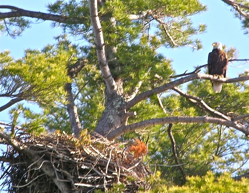
If you want to see bald eagles, we have the place for you – Merrymeeting Bay. In a four-hour, seven-mile paddling outing from the Bay Bridge Landing boat launch site in Brunswick, we enjoyed 10 eagle sightings.
The plan had been to paddle north to the Muddy River in Topsham and explore up to the Foreside Road bridge, but instead we focused on weaving in and out of the islands at the south end of Merrymeeting Bay, where the Androscoggin River empties into a broad basin that gathers waters from five rivers.
Additional Photos
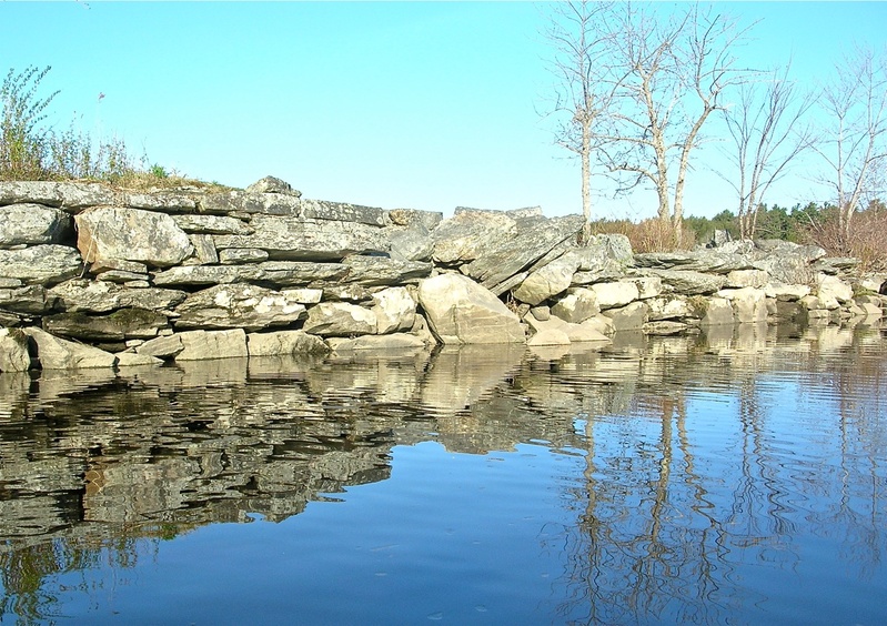
The boat launch is located at the granite remains of the former Merrymeeting Bay Bridge, a 2,700-foot long toll bridge that was built in 1836 and destroyed by a spring flood in 1896. Sixty years of commerce traversed back and forth over the bridge. Ox carts and horse-drawn carriages hauled tons of hay, fresh produce and firewood across the river to the bustling shipping center of Bath. The forested island halfway across the river provided a natural middle span.
It is amazing today to gaze up at the large trees growing on the remains of the granite piers on both sides of Mustard Island. Mother Nature violently reclaimed the bridge by throwing floods, shifting sands and ice at it, and then ever so subtly continued the destruction by nurturing grasses, junipers, pines, birches and oak on its road surface. In a hundred years, will Interstate 95 look the same – completely grown over?
From Cooks Corner in Brunswick follow the Bath Road to the traffic light leading into Lowe’s. Turn left onto the Old Bath Road and follow it for two miles.
At 0.2 miles beyond the Word of God Fellowship Church, turn left onto Driscoll Street. In another 0.2 miles turn left onto the Bay Bridge Road and follow it 0.2 miles to the landing. For help in getting there consult the Delorme Maine Atlas and Gazetteer (map No. 6).
You can drive all the way down the narrow gravel lane to the launch site, and then park back up at the parking area. Many folks were fishing for pike from the granite pier. One of the fellows boldly proclaimed that the next Maine State record pike will most likely come from these waters.
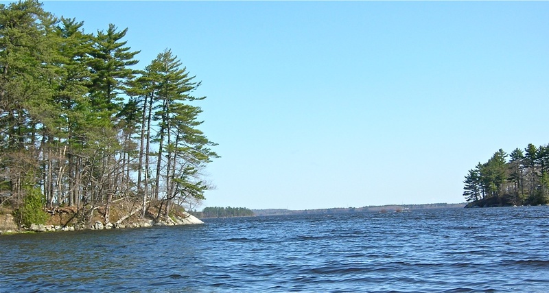
Starting with Mustard Island, a quarter-mile to the west, you can paddle around six islands on your way north toward Bald Head. Some of the islands are high and guarded by steep ledges, others are large sandbars overgrown with trees and vegetation.
Merrymeeting Bay is a huge body of water; think of it as a tidal lake. Its size and positioning make it susceptible to strong winds.
But there are enough protective islands, hidden estuaries and marshes to allow you to adapt your route to the conditions. The bay is one giant buffet line for fish, mammals and birds, making this one of the best areas in the Northeast for wildlife viewing.
The eagles know where the food is.
As we headed back along the eastern shoreline from our turn-around point at a small island 1.5 miles south of Bald Head, we dipped into a winding waterway leading into a vast secluded marsh. All signs of civilization vanished. There was a noticeable current created by the incoming tide, and with a freshening tailwind we flew along. Would we be able to sneak out the other side back into the bay or would we have to backtrack?
Rows of black willows hung over the water providing a natural cathedral. Their yellowish-green spring leaves were brilliant in the late morning sun. The bark and leaves were once used to treat symptoms of rheumatism. Today a synthetic variety of that healing ingredient is the key component of aspirin.
Many radiant green clumps of false hellebore poked up out of the rising water. We came to a small beaver lodge at a fork in the ever-narrowing stream. It was obvious now that we would have to backtrack the half-mile back out to open water, enjoying once again the majesty of willows, the distinctive calls of red-winged blackbirds and kingfisher. As we emerged out into the bay a flock of 50 common mergansers erupted up into the air. We had seen a number of pairs throughout the morning, but 50 rising as one was quite impressive. A loon may define the blackness of black, but surely does the male common merganser define the whiteness of white.
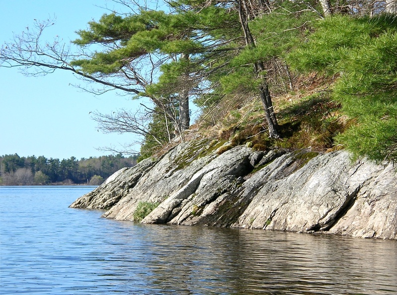
Before heading in, we paddled over to the granite pier on the eastern side of Mustard Island to see if we could find and follow the roadway across the island to the western side. After skirting around a tangle of downed trees, we easily followed the route to the other side. We carefully wove our way through juniper and other leg rippers to the granite blocks teetering at the end. If you are going to hang out on this island, save your hanging out for the level granite blocks on the eastern side. This is a fabulous spot for a picnic lunch, for snoozing in the sun, and for scanning the sky for eagles, osprey and geese. The views up and down the bay are far-reaching and spectacular. With pride you will note the chain of islands you followed up to the Bald Head area, and gazing south maybe you will begin planning a return later in the summer for exploration of the many islands upstream of Mustard Island.
Michael Perry is the former director of the L.L.Bean Outdoor Discovery Schools, and founder of Dreams Unlimited, specializing in inspiring outdoor slide programs for civic groups, businesses, and schools. He can be contacted at:
dreams @suscom-maine.net
Send questions/comments to the editors.

Success. Please wait for the page to reload. If the page does not reload within 5 seconds, please refresh the page.
Enter your email and password to access comments.
Hi, to comment on stories you must . This profile is in addition to your subscription and website login.
Already have a commenting profile? .
Invalid username/password.
Please check your email to confirm and complete your registration.
Only subscribers are eligible to post comments. Please subscribe or login first for digital access. Here’s why.
Use the form below to reset your password. When you've submitted your account email, we will send an email with a reset code.