

It was back in the early part of the 20th century that the great philanthropist John D. Rockefeller Jr. began the construction of a carriage road system on Mount Desert Island that resulted in a unique biking paradise available to all of us.
Development took nearly 30 years, during which time Acadia National Park was created and the roads were opened to the public. Their use by horse-drawn carriages and hikers diminished during the Depression, and even more after the Great Fire of 1947, which I remember seeing from my home in Camden as the eastern horizon glowed red for days. It was in 1949 that Rockefeller himself suggested promoting bicycle use on the roads as carriage use had declined.
Additional Photos
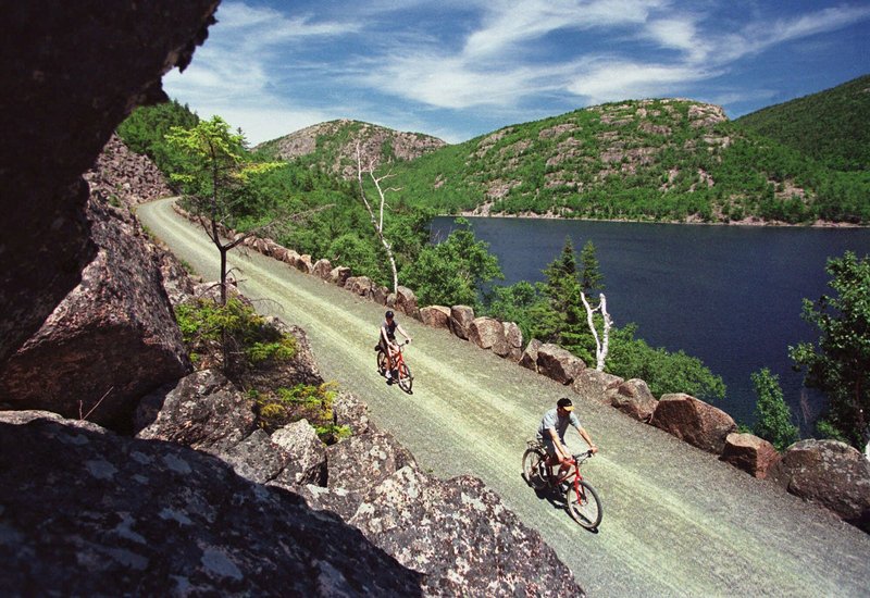
Totaling about 50 miles of well-graded and maintained gravel roads, this system winds its way through some of the most scenic parts of the park, around lakes and ponds, through quiet woods, and over promontories offering unequaled vistas of coastal Down East Maine.
Much of the credit for the current quality of today’s network of roads can be traced to an initiative launched a little more than 20 years ago by The Friends of Acadia, with assistance from the National Park Service and funded by Congress. In 1990, a massive rehabilitation project was undertaken to restore the roads and scenic vistas to their condition of a century ago by cleaning drainage ditches, reopening long-clogged culverts, replanting vegetation, resetting coping stones along the sides of the roads and repointing many of the 170stone bridges that span rivers and cross gorges to link the entire system together.
Every time I head out for a day of biking in Acadia, the toughest decision is the first one: which carriage road, or roads, today. The best thing is that there’s no wrong decision, for every road has its own unique character, and occasional challenge. Regardless, I know I’m in for a special Maine experience.
There is another decision I have to make before I head east at sunrise to get out early on the bike, and that is whether I proceed to the carriage roads, or stay on Route 1 in Ellsworth and go to the spectacular Schoodic section of the park, but more about that later.
My first trip every year, and I make sure it’s in May, well before the summer crowds arrive on the island, is the 6-mile loop around Eagle Lake. There are two parking areas just off the Eagle Lake Road (Route 233). I recommend heading along the west shore with the lake on your left, and you’ll catch regular glimpses of the lake, as well as Cadillac, Pemetic, the Bubbles and Conners Nubble, all of which should be included in your summer hiking schedule. A couple of miles in you’ll pass the trail head for the short hike up Conners Nubble, a hike well worth the few minutes diversion. The road then circles around the south end of the lake and begins a long, nearly flat ride of a couple of miles back to your car. There is another parking area, the Bubble Pond lot, where you can also begin your circuit, but I prefer starting at the north end, as I’ll always toss my kayak on the Jeep when I head for this particular bike ride. There’s easy access for a nice paddle on Eagle Lake after the morning’s exercise.
Another reason I like the loop around Eagle Lake is that the road provides access to the Aunt Betty’s Pond Loop, a usually quieter alternative to circling the lake if the road is a little busy, and it covers just about the same distance. Lots of work has been done in recent years on both the surface and with brush being cleared on the sides. Although containing one of the most challenging uphill climbs in the entire Carriage Roads system, this ride rewards you with six attractive crossings of Chasm Brook as well as a long downhill glide back to the west shore of Eagle Lake, and then it’s back to your car.
Now, let me tell you about Schoodic, if you’ve never been there. It never ceases to amaze me that folk who drive hundreds or even thousands of miles to Acadia don’t take the time to visit this part of the park which is, to me, the quintessential automobile-accessible coastal experience in all of Maine — or on the entire East Coast, for that matter. Granite headlands, rocky beaches and spruce-fir forests, along with crashing waves on the bold outcrops at Schoodic Point make this a place you’ll not only never forget once you’ve been there. It’ll beckon you back time and time again.
And for the biker, it’s a paradise with its 6-mile one-way loop right long the ocean’s edge. I always start at the Frazer Point parking area at the entrance to the peninsula and head south on the one-way loop road. A stop at the Point is a must, as is, I think, a quick hike to the 180-foot-high Anvil just off the Blueberry Hill parking area. The one-way road becomes two-way a couple of miles south of the little village of Birch Harbor, then its back on Route 186 toward Winter Harbor and you car at Frazer Point. A total of about 11 miles and a thousand memories. In recent years a bike lane has been added to Route 186, so it’s a safe and comfortable ride even on the sometimes-busy road.
That’s a taste of biking in Acadia. We’ll talk more later about both the hiking and kayaking opportunities that await you Down East.
John Christie is an author and an avid, life-ong, year-round explorer of the Maine outdoors. He and his son, Josh, will share this space this summer to highlight some of state’s lesser-known places to go and enjoy the beauty only Maine has to offer. He can be contacted at:
jchristie@fairpoint.net
Send questions/comments to the editors.

Success. Please wait for the page to reload. If the page does not reload within 5 seconds, please refresh the page.
Enter your email and password to access comments.
Hi, to comment on stories you must . This profile is in addition to your subscription and website login.
Already have a commenting profile? .
Invalid username/password.
Please check your email to confirm and complete your registration.
Only subscribers are eligible to post comments. Please subscribe or login first for digital access. Here’s why.
Use the form below to reset your password. When you've submitted your account email, we will send an email with a reset code.