


PORTLAND – By Sunday afternoon, coastal portions of Maine should be in the grip of one of the most powerful storms to reach the state since Hurricane Bob struck in 1991.
Bob, which made landfall in Maine on Aug. 20, 1991, caused more than $200 million in damage and left three people dead. Bob also dumped more than 8 inches of rain on the state.
Additional Photos
Last September, Hurricane Earl threatened Maine but swept out to sea, doing most of its damage in Nova Scotia.
“Irene is going to be similar (to Bob),” said Mike Cempa, a meteorologist with the National Weather Service in Gray.
Cempa said that by the time Irene moves over Maine on Sunday, it will most likely bring winds of 30 to 50 mph, with gusts as powerful as 70 mph. That would make it a tropical storm, a notch below a Category 1 hurricane.
“The worst conditions will be seen along the coast,” Cempa said.
The storm will last through the night Sunday and end Monday, most likely by late morning or early afternoon.
The weather service is predicting the storm will drop 2 to 5 inches of rain.
Preparations began earlier this week as state and local officials braced for the worst-case scenario.
“I think we are going to get very significant winds and a lot of rain,” Rob McAleer, director of the Maine Emergency Management Agency, said Thursday. “We are expecting a large number of trees to come down, and power outages. Some people are thinking this storm could be as bad as anything we have seen in a while.”
McAleer said plans are in place if coastal areas need to be evacuated.
One of the factors that concerns officials is an astronomical high tide, which is expected late Sunday night. That tide, combined with a storm surge, could cause coastal flooding.
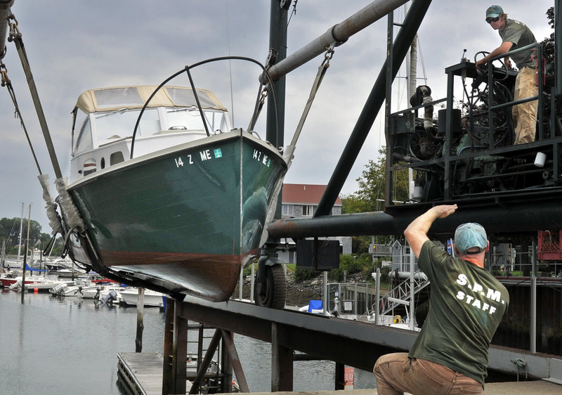
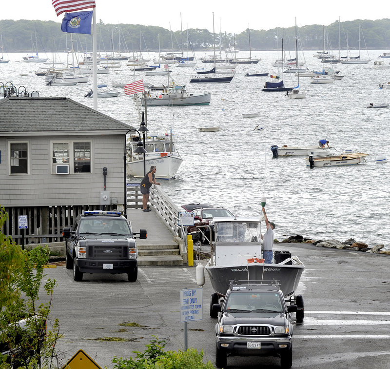
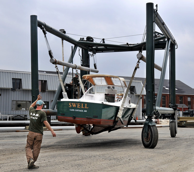
Earlier this week, marinas across the state were put on notice by the Maine Marine Patrol to remove boats from the water to prevent damage not only to the boats, but to docks as well.
Port Harbor Marine, which operates Spring Point Marina and Breakwater Marina in South Portland, took the warnings seriously. Rob Soucy, president of Port Harbor Marine, said Thursday that his crews had removed about 200 boats from the water since the effort began Wednesday.
At the current rate, Soucy said 400 boats could be on land by the time Irene arrives. He just hopes that the storm doesn’t prematurely end the boating season, which typically lasts into September.
“I think most Mainers don’t want the season to end now,” Soucy said.
Central Maine Power Co. has been working closely with MEMA and county emergency agencies as the storm approaches. CMP is anticipating that there will be power outages.
“We’ve put our people on notice and we’ve contacted utility companies and contractors in Maine, in other states, and in Canada to make sure we can bring in extra crews if we need their assistance,” said Tom Depeter, CMP’s director of operations.
AT&T said it is preparing its network for an onslaught of storm-related phone calls.
The company has been adding capacity to its wireless network to accommodate increased call volume and has been testing the high-capacity backup batteries located at each of its cellphone sites, according to a news release.
During an emergency, increased call volume might create network congestion, leading to fast busy signals on wireless phones or slow dialing on land-line phones. AT&T recommends hanging up and waiting for a few seconds before calling again.
Agencies across Maine issued warnings and storm preparation advice Thursday.
The Great State of Maine Air Show will be held in Brunswick on Friday and Saturday, but plans for Sunday remain uncertain due to the possibility of severe weather, said Steve Levesque, executive director of the Midcoast Regional Redevelopment Authority.
“If people are uncomfortable about Sunday they can exchange their tickets for the Saturday show” by going online, Levesque said. The air show website is www.greatstateof maineairshow.us.
“We’re not making any decisions yet,” he said. “We’ll have to wait and see how this plays out. It’s an act of God.”
The Maine Department of Transportation announced Thursday it will close the Penobscot Narrows Bridge observatory in Prospect at noon today. It will reopen at 9 a.m. Tuesday.
The observatory, which is 420 feet above the Penobscot River, will be closed to allow crews to install storm covers over the vented louvers to prevent water from entering the tower during the storm.
The University of New England announced it will postpone student move-in day from Sunday to Tuesday due to the storm. First-year and transfer students will be able to move into their dormitories from 5 a.m. to 12:30 p.m.; upper-class students will be able to move in from 12:30 to 5:30 p.m.
The Muskie Lobster Bake will still be held in Freeport on Sunday beginning at noon, but it has been moved in the interest of safety from an oceanfront tent to the barn at Wolfe’s Neck Farm. U.S. Reps. Mike Michaud and Chellie Pingree and former Gov. John Baldacci are expected to attend.
Staff Writer Dennis Hoey can be contacted at 791-6365 or at:
dhoey@pressherald.com
Send questions/comments to the editors.

Success. Please wait for the page to reload. If the page does not reload within 5 seconds, please refresh the page.
Enter your email and password to access comments.
Hi, to comment on stories you must . This profile is in addition to your subscription and website login.
Already have a commenting profile? .
Invalid username/password.
Please check your email to confirm and complete your registration.
Only subscribers are eligible to post comments. Please subscribe or login first for digital access. Here’s why.
Use the form below to reset your password. When you've submitted your account email, we will send an email with a reset code.