

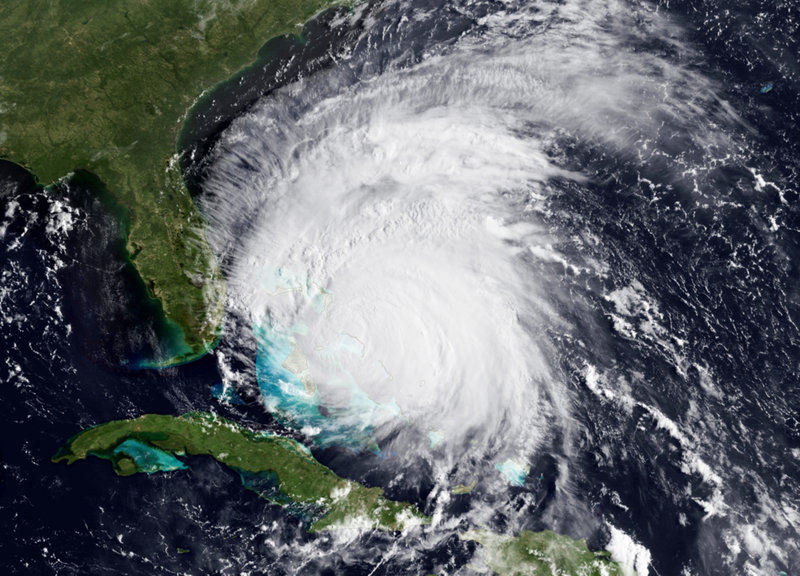
BUXTON, N.C. — A monstrous Hurricane Irene tightened its aim on the Eastern Seaboard on Thursday, threatening 65 million people along a shore-hugging path from North Carolina to New England. One of the nation’s top experts called it a “nightmare” scenario.
The Category 3 storm with winds of 115 mph — the threshold for a major hurricane — would be the strongest to strike the East Coast in seven years, and people were already getting out of the way.
Additional Photos
Tens of thousands fled North Carolina beach towns, farmers pulled up their crops, and the Navy ordered ships to sea so they could endure the punishing wind and waves in open water.
All eyes were on Irene’s projected path, which showed it bringing misery to every city along the I-95 corridor, including Washington, New York and Boston. The former chief of the National Hurricane Center called it one of his three worst possible situations.
“One of my greatest nightmares was having a major hurricane go up the whole Northeast coast,” said Max Mayfield, the center’s retired director.
Mayfield said the damage will probably climb into billions of dollars: “This is going to have an impact on the United States economy,” he said.
The head of the Federal Emergency Management Agency said damages could exceed most previous storms because so many people live along the East Coast and property values are high.
“We’ve got a lot more people that are potentially in the path of this storm,” said FEMA Director Craig Fugate. “This is one of the largest populations that will be impacted by one storm at one time.”
The storm would “have a lot of impact well away from the coastline,” he said. “A little bit of damage over big areas with large populations can add up fast.”
Irene was massive, with tropical-force winds extending almost twice as far as normal, about the same size as Katrina, which devastated New Orleans in 2005.
“It’s not going to be a Katrina, but it’s serious,” said MIT meteorology professor Kerry Emanuel. “People have to take it seriously.”
The governors of North Carolina, Virginia, Maryland, Delaware, New York and New Jersey declared emergencies to free up resources, and authorities all the way to New England urged residents in low-lying areas to gather supplies and learn the way to a safe location.
Irene was expected to come ashore Saturday in North Carolina with 115 mph winds and a storm surge of 5 to 10 feet. It could dump a foot of rain, with as much as 15 inches falling in some places along the coast and around Chesapeake Bay.
Scientists predict Irene will then chug up the coast. Some forecasts showed it taking dead aim at New York City, with its eye passing over Brooklyn and Manhattan before weakening and trudging through New England.
If the storm strikes New York, it will probably be a Category 1 or 2, depending on its exact track, said hurricane specialist John Cangialosi.
Hurricanes are rare in the Northeast because the region’s cooler seas tend to weaken storms as they approach, and they have to take a narrow track to strike New York without first hitting other parts of the coast and weakening there.
Still, strong storms have been known to unleash serious damage in an urban environment already surrounded by water.
A September 1821 hurricane raised tides by 13 feet in an hour and flooded all of Manhattan south of Canal Street — an area that now includes the nation’s financial capital. An infamous 1938 storm dubbed the Long Island Express came ashore about 75 miles east of the city and then hit New England, killing 700 people and leaving 63,000 homeless.
With heavy rain and storm surge predicted for the nation’s capital, organizers postponed Sunday’s dedication of the Martin Luther King Jr. Memorial on the National Mall.
Already in South Florida near West Palm Beach, authorities blame the rough ocean churned up by the outer bands of Irene for causing eight people to be injured when a wave knocked them off a jetty.
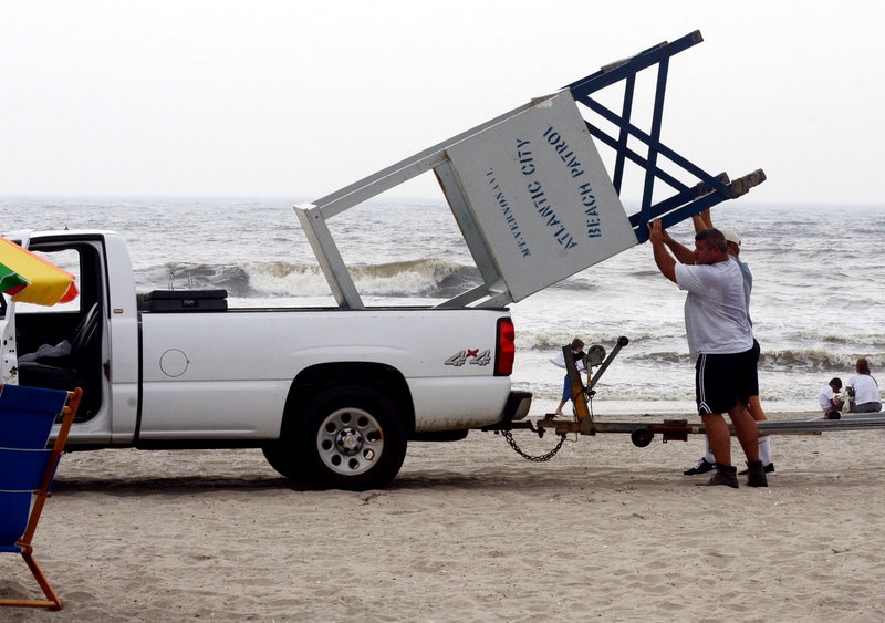
On Thursday, Ocean City, Md., officials ordered thousands of residents and tourists to abandon the beach community. Earlier in North Carolina, three coastal counties issued evacuation orders covering more than 200,000 people, including tourists and full-time residents. President Obama declared an emergency for the state, allowing for federal help.
Farmers grimly accepted the fate of their crops. Strong winds and widespread flooding could mean billions of dollars in losses for corn, cotton, soybean, tobacco and timber growers. While most farmers have disaster insurance, policies often pay only about 70 percent of actual losses.
In Virginia, officials recalled Hurricane Isabel in 2003, which came ashore as a Category 1, killed more than 30 people and caused more than $1 billion in property damage. The low-lying Hampton Roads region is at high risk of flooding from storm surge and heavy rains. Widespread power outages are likely.
The Navy ordered many of its ships at Norfolk Naval Station out to sea to wait out the storm, including the aircraft carrier USS Dwight Eisenhower, as well as destroyers and submarines.
In Washington, where residents were rattled by a rare earthquake Tuesday, officials warned people to be prepared for stormy conditions regardless of Irene’s exact path and to stay away from the beaches in the region.
The Philadelphia area could get more than a half-foot of rain, accompanied by sustained winds up to 50 mph. Mayor Michael Nutter said it could be the worst storm in at least 50 years. August has already been one of the rainiest months in city history.
New Jersey Gov. Chris Christie asked all visitors to the shore to get out by midday today. He said Irene was poised to be a “serious, significant event,” with flooding a threat across the entire state. A mandatory evacuation was ordered for Cape May County.
In a normal hurricane, tropical storm-force winds extend about 150 miles from the eye. Irene’s winds extend nearly 250 miles.
Another worry is that the ground is already saturated in the Northeast after a wet spring and summer. That means trees and power lines will be more vulnerable to winds, like during Hurricane Isabel, Mayfield said.
New York is especially susceptible with its large subway network and the waterways around the city, Mayfield said.
“In many ways, a Category 2 or stronger storm hitting New York is a lot of people’s nightmare,” said Susan Cutter, director of the Hazards and Vulnerability Research Institute at the University of South Carolina.
High water in the harbor and rivers, along with a high tide at the end of the month because of the new moon, could cause serious flooding. New York’s three airports are close to the water, putting them at risk, too.
And if the storm shifts farther to the west, placing New York City on the stronger right-hand quadrant of the storm, “that is what’s going to push this wall of water into the bays and the Hudson River,” she said.
Send questions/comments to the editors.

Success. Please wait for the page to reload. If the page does not reload within 5 seconds, please refresh the page.
Enter your email and password to access comments.
Hi, to comment on stories you must . This profile is in addition to your subscription and website login.
Already have a commenting profile? .
Invalid username/password.
Please check your email to confirm and complete your registration.
Only subscribers are eligible to post comments. Please subscribe or login first for digital access. Here’s why.
Use the form below to reset your password. When you've submitted your account email, we will send an email with a reset code.