


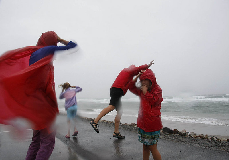
Tropical Storm Irene blew through Maine on Sunday, knocking out power to more than 190,000 customers and causing scattered flash flooding but failing to produce the widespread damage that had been feared.
The punishing hurricane had been downgraded to a tropical storm by the time it reached Maine, but Irene still brought powerful sustained winds and gusts that caused rain-soaked trees and limbs to fall on power lines in widely scattered locations. The wind was expected to continue gusting to 50 mph through the night, the National Weather Service said.
Additional Photos

As of Sunday evening, coastal residents had largely been spared the flooding that many had feared. The storm took a westerly track that directed the brunt of its force inland.
“We’ve seen nor’easters that have been bigger, but this one is still impressive. You get the sea spray in your face. That’s what it’s all about, a little taste of the sea,” Joe Rolland of Kennebunk said as he watched the waves crash against the rocky shore in Kennebunkport, sending spray shooting upward.
Although the rain ended earlier than expected in southern Maine, the Maine Emergency Management Agency issued a reminder that the storm was not over and dangerous conditions could last into today, especially near the coast where the surf could remain high. But the skies are expected to clear by midday today, and the forecast calls for sun with a high near 80.
On Sunday, wind gusts reached up to 52 mph at the Portland International Jetport, according to the National Weather Service in Gray.
As of 9 p.m. Sunday, more than 182,000 Central Maine Power customers had no power, which is more than one-quarter of CMP’s 610,000 customers, the utility said. CMP said it could take several days before electrical service is restored to all customers.
Hardest-hit was York County, with 44,545 customers without power, followed closely by Cumberland County at 34,330 and Kennebec County at 29,704.
“Customers should be prepared for some extended outages,” said CMP spokesman John Carroll.
Farther north, Bangor Hydro-Electric Co. reported more than 13,200 outages, the bulk of them in Hancock County.
Numerous trees were reported knocked down by the wind, including one that loomed menacingly over Route 302 while caught in power lines in the Windham area.
The storm’s precursor, a band of tropical rain that drenched the state Saturday night into Sunday morning, set the stage for trees to fall by softening the ground around the roots.
Rainfall amounts by 5 p.m. in the Portland area were not significant — just under 2 inches — said Margaret Curtis, a meteorologist with the National Weather Service in Gray.
But in northern Cumberland County and the mountains of western Maine, rainfall totals were considerably higher. The heaviest rain was in the western part of the state, where meteorologists estimated that 8 to 9 inches had fallen in northern Oxford County. By 5 p.m., Casco had received 3.16 inches of rain, Gorham had just over 2 inches and Denmark 3.25 inches.
Areas in central Maine had rainfall totals in the 2-4 inches range.
Motorists across the state are dealing with washed-out roads and road closures because of downed trees and wires, especially in the Lakes region, Oxford County and western Maine.
Most significantly, Route 27 at Carrabasset Valley, just north of the access road to Sugarloaf Mountain, is closed indefinitely, said state police spokesman Stephen McCausland. “The bridge was affected, and I am assuming it was washed out,” he said.
A Stratton resident said the bridge washed out about 5 p.m.
It’s a key road, because it takes traffic north into Quebec.
High water closed a bridge on Route 4 in nearby Madrid, which would provide an alternate for the Route 27 closure. The Madrid bridge closed Sunday night because of high water, but is structurally sound, McCausland said.
The Madrid bridge should reopen today, providing an alternate to the Route 27 washout. “The Madrid bridge will get attention as early as (today). It’s the only viable route north of Sugarloaf,” he said.
At 8 p.m., 110 roads were closed statewide, most because of downed trees and wires and some because of flooding.
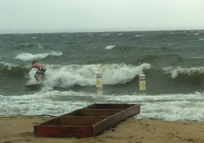
Maine’s beaches took a pounding from the heavy surf, but no major flooding was reported, at least from the 11 a.m. high tide. There was some minor flooding at Portland Pier about 10:30 p.m. Sunday. Another high tide was due to occur at 11:11 p.m.
The greatest danger on the coast may have been from curious residents who flocked to the water’s edge to take in the spectacle.
Old Orchard Beach officials closed the beach, and Scarborough police turned nonresidents away from Higgins Beach so locals could find a place to park their cars.
Rob McAleer, director of the Maine Emergency Management Agency, said he was unaware of any storm-related accidents or fatalities, but he did receive a report that the town of Sanford had to rescue a couple of kids who became stranded on a paddleboat in Number One Pond.
“It’s time for people to be smart, and that is not smart at all,” McAleer said.
He said he still had several storm-related concerns — “the extent of the power outages and the cleanup of downed power lines and tree limbs. It’s going to take awhile. It’s not like clearing snow.”
McAleer said the heavy rain in the western mountain regions of the state also could lead to flooding in rivers such as the Saco, which runs through Fryeburg, Buxton and Biddeford.
In southern Maine, the storm had a wide-ranging impact. About 30 shelters were opened, the Portland International Jetport canceled all its flights, and Old Orchard Beach was closed to swimmers on what would have been a busy summer beach day if not for the weather.
About 16 people spent the night at the city of Portland’s emergency shelter at the Portland Exposition Building on Park Avenue. The city’s Oxford Street Shelter, which accommodates the city’s homeless population, remained open during the storm.
Paul Bradbury, the jetport’s director, said a total of 97 inbound and outbound flights had to be canceled Sunday due to the storm. Those cancellations affected about 6,400 passengers, who were forced to make other arrangements.
“July and August are our busiest months. This had a significant impact on our business,” Bradbury said.
Commercial flights are expected to resume this morning, although some flights have already been canceled.
In South Portland, motorists were discouraged from using Broadway after an early morning water break near the municipal golf course forced police to reduce travel to one lane of traffic.
Robb Couture, spokesman for the South Portland Fire Department, said the cause of the break is not known.
The Portland Water District is expected to repair the line this morning, but in the meantime customers should expect their water pressure to remain low.
Couture said power lines damaged by winds near 700 Westbrook St. won’t be repaired until today. He said that means residents of Redbank, Brickhill, Courtland Court and Liberty Commons will be without power.
In Westbrook, a section of East Bridge Street near Route 302 that is currently under construction had to be closed after it became flooded. Greg Hamilton, the city’s emergency management director, said the temporary detour is below grade, which caused the Presumpcot River to flood that section.
A few people tried the make the best of a difficult situation.
At the Frog & Turtle in Westbrook, the staff served a hurricane-themed brunch that included tropical mimosas.
The gates of Fort Williams Park in Cape Elizabeth were locked Sunday, but that didn’t stop dozens of pedestrians, joggers and dog walkers from finding their way into the park.
Max Loeffler, 17, and Lillian Grassin-Drake, 14, of Cape Elizabeth took to the swings overlooking the surging surf of Ship Cove, a few hundred yards north of the Portland Head Light.
“We both got lectures from our parents about avoiding the rogue waves and everything,” said Loeffler, “(and) definitely not (get) close enough to touch the water. But I would say as far as the whole storm went, it was a little bit overblown, no pun intended.”
Leon Anderson, an artist from Portland, stood out on a ledge for 15 minutes taking in the views. He brought along a waterproof camera.
“A photograph doesn’t do,” he said. “I really have to stare at it and see what is in the scene that I want to get. There’s a lot of color in these rocks. But when you look at a photograph of it, it’s just dead gray.”
Staff Writer Glenn Jordan and The Associated Press contributed to this story.
Staff Writer Dennis Hoey can be contacted at 791-6365 or at:
dhoey@pressherald.com
Send questions/comments to the editors.

Success. Please wait for the page to reload. If the page does not reload within 5 seconds, please refresh the page.
Enter your email and password to access comments.
Hi, to comment on stories you must . This profile is in addition to your subscription and website login.
Already have a commenting profile? .
Invalid username/password.
Please check your email to confirm and complete your registration.
Only subscribers are eligible to post comments. Please subscribe or login first for digital access. Here’s why.
Use the form below to reset your password. When you've submitted your account email, we will send an email with a reset code.