

CARRABASSETT VALLEY — A bridge that collapsed into the Carrabassett River during Tropical Storm Irene was scheduled for repairs because of a design flaw that made it more likely to fail during severe storms.
The bridge, built in 1958, was to be repaired within the next 12 months because of the flaw in its support system, which becomes a danger only during flooding, said John Buxton, bridge maintenance engineer for the Maine Department of Transportation.
Additional Photos
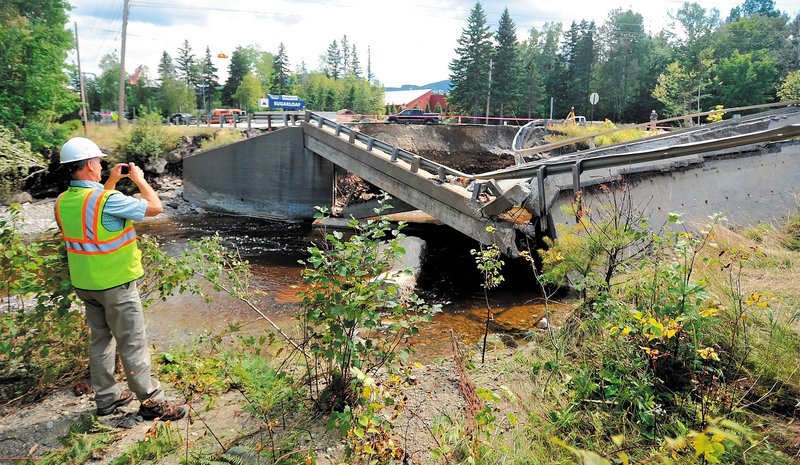
It was one of two bridges on Route 27 that crumbled into raging, flooded waterways in Carrabassett Valley on Sunday afternoon.
Buxton said Tuesday that he is trying to determine the specifics of the collapses. The answers may help prevent future failures because 129 other state-owned bridges have similar support-system flaws, related mostly to pre-1960 designs regarding soil erosion, he said.
A team of engineers and scientists is looking into what caused the two bridges to collapse, but early signs point to stormwater overwhelming them, Buxton said. He described it as localized flooding that would have caused a variety of bridges to fail.
Buxton said he believes the water levels met guidelines for a 100-year flood, which refers to a system that rates storms based on how they compare with average annual rainfall. A National Weather Service spokesman confirmed reports that 8.5 inches of rain likely fell in the area where the bridges failed.
The other bridge that collapsed on Route 27, falling into nearby Brackett Brook, which feeds into the Carrabassett, was built to replace a smaller, less durable bridge. State engineers thought the original model couldn’t stand up to frequent flooding at the site, Buxton said.
Hundreds of state employees monitored road and bridge conditions throughout the state during the storm. They measured water levels all day to determine whether to close bridges, and many were shut down because of flooding, he said.
One crew measured water levels at the bridges in Carrabassett Valley just two hours before they collapsed within minutes of each other, around 4:30 p.m.
The water rose at least 2 feet during the next two hours, going from levels 3 feet below those considered dangerous to spilling over the bridges, Buxton said. He said the crew arrived back at the bridges soon after they collapsed.
Buxton said the two-hour lapse was because the crew had to check other bridges. A total of 2,753 state-owned bridges were monitored during the storm, he said.
The 129 bridges flagged for the same flaw as the one built in 1958 that collapsed are stable for everyday use, and most are expected to have a life span of 75 to 100 years, Buxton said.
The flaw is that support beams become unstable because of soil erosion during severe storms. The state manages the problem by increasing inspections and maintenance, he said.
Engineers are looking at installing temporary bridges and improving private dirt roads as temporary fixes so people can get around where the two bridges collapsed, with some traffic being detoured around nearby highways. The long-term plan is to replace both bridges.
Morning Sentinel Staff Writer David Robinson can be contacted at 861-9287 or at: drobinson@centralmaine.com
Send questions/comments to the editors.

Success. Please wait for the page to reload. If the page does not reload within 5 seconds, please refresh the page.
Enter your email and password to access comments.
Hi, to comment on stories you must . This profile is in addition to your subscription and website login.
Already have a commenting profile? .
Invalid username/password.
Please check your email to confirm and complete your registration.
Only subscribers are eligible to post comments. Please subscribe or login first for digital access. Here’s why.
Use the form below to reset your password. When you've submitted your account email, we will send an email with a reset code.