

A team of scientists from various public agencies, universities and nonprofits leaves today on a weeklong expedition to create unprecedented sonar maps and digital detailing of the sea floor off Maine’s coast.
Until now, no one has gotten a good look — or created a good map — beyond the federal three-mile territorial limit.
Additional Photos
Within a week, the survey will produce the first maps focused on an estimated 50 square miles of sea floor about 15 to 20 miles off the coast.
Those maps, officials say, could aid efforts to oversee and manage the many uses of the ocean, such as shipping, fishing, aquaculture and wind energy development, and provide data for future decisions on marine matters and off-shore development.
Potentially, the area to be mapped presents opportunities for fisheries and wind farms, tourism and shipping, among many other uses.
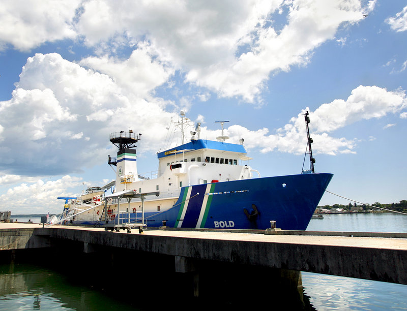
Where there are numerous — and possibly competing — uses, public officials have to safeguard the sea and the ocean floor so “the environment (can) be preserved,” said Maine Conservation Commissioner Bill Beardsley, one of several state officials who were at Portland’s International Marine Terminal on Monday to announce the expedition and tour the Environmental Protection Agency’s ocean survey vessel Bold.
The agency’s 224-foot-long research vessel is equipped with sampling, mapping and analysis equipment. The EPA is funding about $100,000 to $150,000 of the cost of the Bold’s six-day expedition; the state is paying only for the salaries of its scientists who work on the mapping and the analysis after the voyage.
Just as the state needs a conservation department for land-use planning, Beardsley said, it is critically important “to develop a topography of the ocean, moving into the 21st century. There’s the opportunity for economic growth but also environmental problems.
“The area we know least about is that submerged lane,” he said, describing the survey area southeast of Cape Elizabeth.
The swath of the sea is where much activity occurs, including human commerce and future energy development, as well as the movements of marine mammals and some migrations of sea birds.
“The impact of what happens on land is not insignificant for what happens in the water” and vice versa, said Maine Agriculture Commissioner Walt Whitcomb. “This innovative scientific research hopefully will provide more answers than questions concerning the interaction between our land-based natural resources and the ocean floor.”
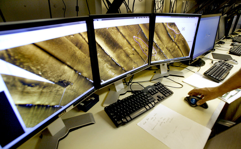
Eight state scientists from various agencies, universities and nonprofits are collaborating on the mapping. Equipment will run 24 hours a day throughout the week, compiling a “cascading waterfall” of sonic images of the ocean floor, said Matthew Liebman, an environmental scientist with the EPA’s New England office.
Also aboard are two scientists observing birds and wildlife and five scientists observing marine mammals such as whales and dolphins.
The mapping team — marine geologists and scientists from the state departments of Conservation and Marine Resources, the University of Maine and the EPA — will take multi-beam sonar images of the sea floor at depths to 300 feet, and record and analyze everything from temperature and water quality to salinity and the presence of chlorophyll.
The new maps will focus on a 50-square-mile area — about twice the size of Portland — that includes important lobster fishing grounds and potential sites for wind turbines and cables.
The collaborative research is the first of its kind by the state, said Matt Nixon, a senior planner in the conservation department and one of three principal investigators on the expedition.
“We want to get more accurate information about the ‘lay of the land’ of the ocean, much like a surveyor does on land,” Nixon said.
“All we have now are depth estimations, 19th-century lead-line soundings, and sporadic, high-resolution maps focused on very specific, small locations, typically inshore,” Nixon said. “It will be good to have an idea of true depth out there with sound-generated pictures of what the bottom looks like.”
Undersea mapping traces back to the late 17th century. For more than 200 years, it relied on single-depth soundings, produced by lowering weighted lines into the water. When the lines went slack, it meant the bottom had been reached.
Several incarnations and acoustic and physiographic improvements occurred over time, with sonar introduced during World War I, using underwater sound projectors. Perhaps the most dramatic changes came with the advent of computers and digital imaging and analysis.
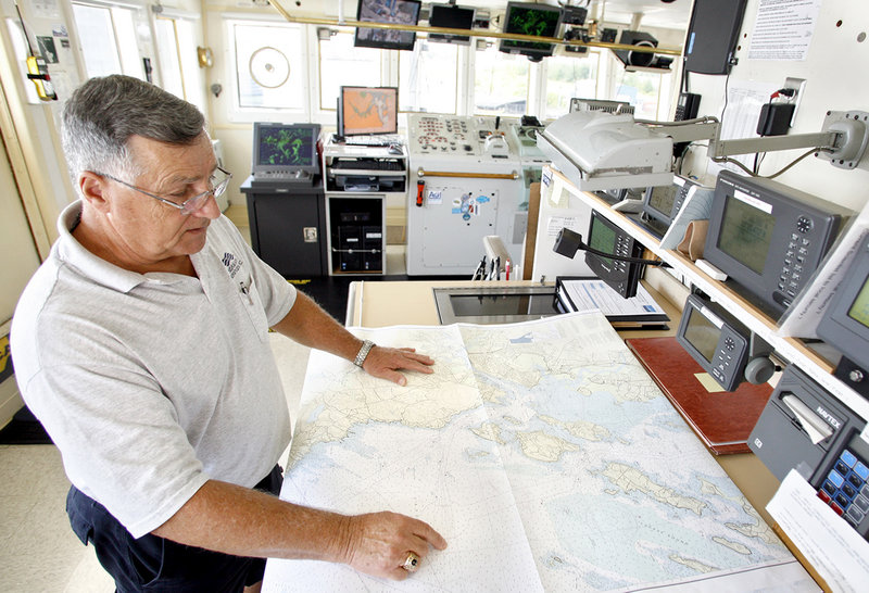
The Bold scientific party is led by EPA Chief Scientist Liebman and two other principal investigators: Stephen Dickson, marine geologist in the conservation department’s Maine Geological Survey; and Carl Wilson, senior lobster scientist in the marine resources department.
Other scientists and observers are from the Biodiversity Research Institute, the University of Southern Maine and the University of New Hampshire. The scientists will issue a final report within two months, and make much of the data available online as part of a coastal atlas.
Staff Writer North Cairn can be contacted at 791-6325 or at: ncairn@mainetoday.com
Send questions/comments to the editors.

Success. Please wait for the page to reload. If the page does not reload within 5 seconds, please refresh the page.
Enter your email and password to access comments.
Hi, to comment on stories you must . This profile is in addition to your subscription and website login.
Already have a commenting profile? .
Invalid username/password.
Please check your email to confirm and complete your registration.
Only subscribers are eligible to post comments. Please subscribe or login first for digital access. Here’s why.
Use the form below to reset your password. When you've submitted your account email, we will send an email with a reset code.