


As Tropical Storm Sandy morphed into Hurricane Sandy on Wednesday, the jury was still out on how the storm would track north from the Caribbean, leaving East Coast residents waiting and watching.
The storm’s winds intensified to more than 80 mph as it approached Jamaica, making it the season’s 10th hurricane. High winds and torrential rain are expected to buffet Jamaica by Wednesday evening and will hit other islands as well, but it’s still too early to tell what will happen after that.
Additional Photos

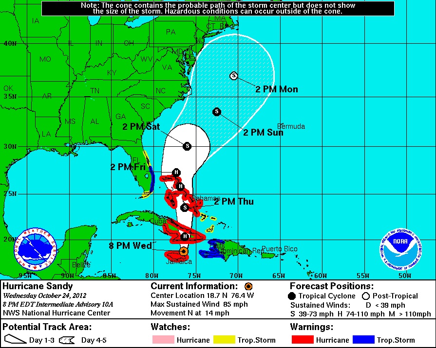
Some weather models show a “slingshot” scenario in which the storm would merge with the jet stream off the coast of North Carolina and then rapidly track north through New England, gaining strength along the way.
Other models predict the storm will avoid the jet stream and meander east, avoiding landfall.
The models were evenly split on Wednesday, according to University of Miami researcher Brian McNoldy, writing for the Washington Post.
“It’s unclear yet which [model] will verify, if any, but the ensembles have been trending westward, with more members now showing a very powerful cyclone slamming into the mid-Atlantic and Northeast states,” he wrote Wednesday.
“Given the model trends and the potential impact a storm like this would have on the U.S., it would be wise to begin basic preparations, particularly in terms of the coastal flooding risk over such a large area. Severe conditions could start affecting the mid-Atlantic states as early as Sunday.”
In Maine, the storm was being watched closely this week but it was still too early to panic.
“We’re not trying to get people too excited just yet. A lot of things can happen in the next week,” said Eric Sinsabaugh, a meteorologist with the National Weather Service in Gray. “But it’s something that has our attention.”
It’s unusual to talk about weather possibilities so far out, but this storm’s potential has experts up and down the East Coast talking.
Eric Holthaus, a meteorologist for The Wall Street Journal, wrote Monday that it could be one for the record books.
“What could happen is quite complicated, and may have precedence only a handful of times across the more than 200 years of detailed historical local weather record keeping,” he wrote.
Andrew Freedman of the Climate Central website also wrote Monday about the storm’s possibilities.
“Think if a hurricane and nor’easter mated, possibly spawning a very rare and powerful hybrid storm, slamming into the Boston-Washington corridor early next week, with rain, inland snow, damaging winds and potential storm surge flooding.”
Such October storms are rare, but when they hit they are memorable. The “perfect storm” of 1991 that crippled a Massachusetts fishing boat and killed its passengers happened in late October.
Last year, an October storm dumped two feet of snow on parts of the Northeast and set records in some Maine communities.
AccuWeather.com’s Hurricane Center projected with some certainty Tuesday that Tropical Storm Sandy will bring flooding rain to Jamaica, parts of Cuba and the Bahamas by Thursday.
What happens on Friday likely will determine the storm’s future.
If the storm tracks east, the Atlantic states are likely to get only cooler air and intermittent showers. If the storm shifts west, New England could be hit hardest because the storm likely would gather strength.
Staff Writer Eric Russell can be contacted at 791-6344 or at:
erussell@mainetoday.com
Twitter: @PPHEricRussell
Send questions/comments to the editors.

Success. Please wait for the page to reload. If the page does not reload within 5 seconds, please refresh the page.
Enter your email and password to access comments.
Hi, to comment on stories you must . This profile is in addition to your subscription and website login.
Already have a commenting profile? .
Invalid username/password.
Please check your email to confirm and complete your registration.
Only subscribers are eligible to post comments. Please subscribe or login first for digital access. Here’s why.
Use the form below to reset your password. When you've submitted your account email, we will send an email with a reset code.