

The “Frankenstorm” expected to slam into Delaware on Tuesday will bring heavy rain and winds to Maine and lead to scattered power outages here, the National Weather Service says.
The heaviest rain in Maine will fall between Monday afternoon though Tuesday, said meteorologist Tom Hawley. Wind gusts in Maine are expected between 40 to 60 mph for an eight- to 12-hour period on Monday and Tuesday, he said.
Additional Photos
He said Maine can expect three to five inches of rain, with the heaviest rain and wind occurring in the southern portion of the state.
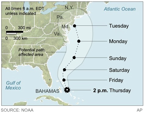
Sandy, now a category 1 hurricane with peak winds of 80 mph, hit the Bahamas on Thursday and is expected to reorganize and strengthen as it winds its way toward the mid-Atlantic. When the storm collides with a large cold front now moving into the East, it will create a huge hybrid storm that will affect a much larger area than a tropical storm would, Hawley said.
The chances of the storm striking New England directly are now remote, he said. After the storm makes landfall in Delaware, he said, wind currents will trap it for several days in the Pennsylvania and western New York state area. As a result, Maine will experience tropical showers and downpours through Friday.
Officials at Central Maine Power are now preparing for the storm by lining up the work crews and contractors who would repair damaged power lines. The leaves that remain on many trees could act as “sails” and cause branches and limbs to break and fall on electrical lines, said Gail Rice, spokeswoman for Central Maine Power.
In addition, rain-soaked soil would make it easier for high winds to uproot trees, she said.
“We are preparing for the worst,” she said. “If the storm does end up going to the south and sparing us, that would be a relief.”
Send questions/comments to the editors.

Success. Please wait for the page to reload. If the page does not reload within 5 seconds, please refresh the page.
Enter your email and password to access comments.
Hi, to comment on stories you must . This profile is in addition to your subscription and website login.
Already have a commenting profile? .
Invalid username/password.
Please check your email to confirm and complete your registration.
Only subscribers are eligible to post comments. Please subscribe or login first for digital access. Here’s why.
Use the form below to reset your password. When you've submitted your account email, we will send an email with a reset code.