


Portland Trails announced Tuesday that it is preserving land in the Presumpscot River estuary, alongside the northbound lanes of Interstate 295.
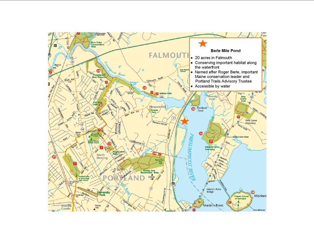
Officials with the conservation organization said they have acquired roughly 20 acres of land surrounding Mile Pond, just south of the bridge that carries I-295 over the Presumpscot River in Falmouth. The pond, which is only accessible by water for several hours around high tide, is located next to I-295’s northbound lanes. An additional small pond – one of several trailing from Mile Pond – was also included in the deal.
Additional Photos
“Conserving land along the historically and ecologically important Presumpscot Estuary is critical for the health of Casco Bay,” Portland Trails executive director Kara Wooldrik said in a statement, noting that the property is located close to two other previously conserved parcels. “While being important for conservation, this land will also provide a unique opportunity for the public to access undeveloped waterfront property near the city.”
The property is located across the Presumpscot estuary from Maine Audubon’s Gilsland Farm, a 65-acre nature sanctuary. In 2006, Portland Trails also conserved shoreline just north of Gilsland Farm at Brickyard Point in Falmouth. Wooldrik said Portland Trails has built a walking trail around part of Mile Pond – which is being renamed Berle Mile Pond after organization supporter and advisory trustee Roger Berle – but the trail is only accessible by water.
The organization acquired the land from private owners for $10,000 with financial assistance from a private donor and the Casco Bay Estuary Partnership, which was formed after the U.S. Environmental Protection Agency added Casco Bay to its list of estuaries of “national significance.” The property was valued at $26,000, Wooldrik said.
“By protecting this land, we contribute to protecting water quality and also protect the adjacent tidal flats, which provide regionally important habitat for a variety of shorebirds,” Curtis Bohlen, director of the Casco Bay Estuary Partnership, said in a statement. “Over the past few weeks, I have really come to appreciate the importance of protected land along the Presumpscot as I watched osprey preying on migrating alewife and saw large numbers of shorebirds feeding on the adjacent mud flats.”
According to historical accounts, the pond was long used by local Indian tribes. During the Civil War, a team of 200 men and 50 horses dug a canal to the pond as part of a never-executed plan to service ships there. The string of small ponds trailing from Berle Mile Pond are remnants of that canal, Wooldrik said.
Send questions/comments to the editors.

Success. Please wait for the page to reload. If the page does not reload within 5 seconds, please refresh the page.
Enter your email and password to access comments.
Hi, to comment on stories you must . This profile is in addition to your subscription and website login.
Already have a commenting profile? .
Invalid username/password.
Please check your email to confirm and complete your registration.
Only subscribers are eligible to post comments. Please subscribe or login first for digital access. Here’s why.
Use the form below to reset your password. When you've submitted your account email, we will send an email with a reset code.