


AUGUSTA — This winter’s “dramatically deep” snow and a forecast calling for an extended period of cold weather have put central Maine, as well as Portland and other coastal communities, at risk of small stream and road flooding.
The threat of flooding in coastal areas in late March and April was identified as a concern Thursday during a meeting of the Maine River Flow Advisory Commission.
Members of the commission, which included Tom Hawley, a hydrologist from the National Weather Service in Gray, as well as state, federal, local and other officials monitoring spring flood risk, met in Augusta to review hydrologic conditions and short-term weather forecasts for the state.
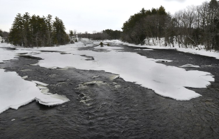
Hawley said models show that late March could warm with possible rainfall, the driving factor for flooding. Complicating matters is Maine’s large snowpack. Augusta, for instance, has had 85 inches of snow this winter with 18 to 36 inches still on the ground in most places. Portland has had 91 inches of snow with 21 inches remaining on the ground.
“The later into the spring you go with a large snowpack, the greater the chances of a rapid warm-up with rainfall (that can lead to widespread flooding),” Hawley said.
Hawley said snow depths are “dramatically above normal” for this time of year in the areas around Portland, Bangor and Machias. In addition to deep snow, snowpack water content – the water that would be produced if the snowpack melted all at once – is also on the high side. The largest amounts – 7 to 8 inches equivalent – can be found in a swath stretching from the midcoast to Downeast.
“The amount of snow on the ground does not mean flooding is inevitable,” Robert Lent, director of the United States Geological Survey in Maine and commission co-chair, said in a statement. “It does mean we have risk factors in place that could become critical when temperatures warm and we begin to see rain instead of snow.”
Snow surveys conducted on March 2 and 3 revealed that snowpack water content ranged from 5 to 8 inches statewide. Currently, there is 21 inches of snow on the ground in Portland with 5.8 inches of water content, according to Margaret Curtis, a meteorologist with the National Weather Service in Gray.
“If everything magically melted tomorrow (in Portland) it would be like dumping 5.8 inches of rain into the rivers and streams. But, it’s going to be cold the rest of the week and that is not likely to happen,” Curtis said.
However, the commission said, those water content levels in Portland, midcoast and downeast Maine are some of the highest they have seen in the past 10 years. In contrast, areas at the headwaters of the Kennebec, Androscoggin and Penobscot rivers have water content levels in the normal range. In the far north, water content levels are the lowest in 10 years. The weather pattern that has developed this winter – with high water content in Portland and along the coast – is the opposite of the norm, the River Flow Advisory Commission said.
“Accordingly, the potential for small stream and urban flooding is elevated closer to the coast, while the flood potential for mainstem rivers is more in the normal range,” the commission said.
The commission said the best case scenario would be days that remain above freezing and cooler nights, conditions that would allow snow to melt gradually.
“A lot will depend on how quickly things happen,” Curtis said. Weather extremes like the record breaking 82 degree temperature in Portland on March 22, 2012, could lead to flooding complications, Curtis said.
“We’ve got a long way to go before we get to that point,” Curtis said, noting that temperatures are expected to reach only 40 degrees in Portland by the middle of next week.
The commission said it is also keeping a close watch on river ice. If ice packs jam up, the water behind them can rise several feet in a few minutes. When an ice jam releases, water levels downstream can rise suddenly.
Commission members said the United States Coast Guard is available to break ice on the Penobscot and Kennebec rivers if needed.
On the Kennebec River around Augusta, there are 10 to 20 inches of ice, which is normal, said Gregory Stewart, data section chief for the U.S. Geological Survey in Augusta.
However, there are two areas of particular concern: an ice jam that’s been on the river in Madison since January near the confluence with the Carrabassett River and the area upstream of the new Richmond-Dresden bridge.
The Madison jam has caused flooding leading up to River Road, but the water has receded, said Michael Smith, director of the Somerset County Emergency Management Agency. Now snow has obscured it, and he said his office remains in a holding pattern until it can assess the weather at March’s end.
Stewart said ice also is building around the piers of the new Maine Kennebec Bridge linking Richmond and Dresden, which could pose a risk for jams later on.
Perhaps no place in Maine is affected by river flooding as much as Hallowell, where the downtown is deeply set in a flood plain. Police Chief Eric Nason, the city’s emergency management director, said he’s hoping for a slow melt with little precipitation into April.
If that doesn’t happen, he said the city is ready.
“We’ve been doing this for so many years that the business owners have prepared very well for these types of events,” he said, “because sometimes we deal with these issues half a dozen times a spring.”
Send questions/comments to the editors.

Success. Please wait for the page to reload. If the page does not reload within 5 seconds, please refresh the page.
Enter your email and password to access comments.
Hi, to comment on stories you must . This profile is in addition to your subscription and website login.
Already have a commenting profile? .
Invalid username/password.
Please check your email to confirm and complete your registration.
Only subscribers are eligible to post comments. Please subscribe or login first for digital access. Here’s why.
Use the form below to reset your password. When you've submitted your account email, we will send an email with a reset code.