

For 52 miles, the Appalachian Trail threads a pleasant route through the hills and mountains of Litchfield County in northwestern Connecticut. The trail is never far from the winding and scenic Housatonic River, and even follows along it for five easy miles, the longest stretch of level walking on the entire AT.
Atop Mount Algo, I encountered my first ever timber rattlesnake. Another hiker was prodding it away with a trekking pole, so I made a wide arc around and quickly moved on.
ON THE TRAIL
Carey Kish is providing reports as he hikes the Appalachian Trail. You can follow his blog at mainetoday.com/author/ckish
A couple days later on Sharon Mountain, I nearly stepped on another rattler. I’d only been on the trail five minutes that morning. I’m not sure what made me look down, but I’m glad I did because I was about to put my right boot on the black tail of a 5-foot long Crotalus horridus in the middle of the trail. I bounded several feet off the path to the right while the snake slithered left into the brush, curled up and began to rattle its tail. Heart pounding wildly, I zoomed in with my camera, then let it be and hurried north.
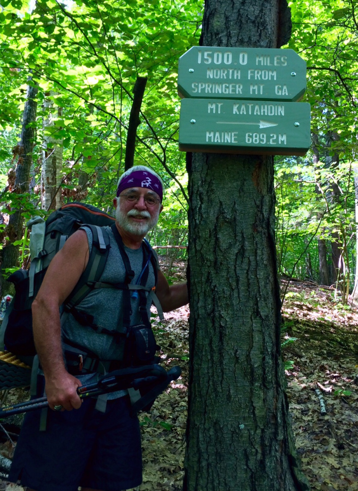
Just out of Salisbury, the trail reaches the 1,500-mile mark before climbing 2,316-foot Bear Mountain, Connecticut’s highest peak. I didn’t get much time to enjoy the view as I was chased off the summit rocks by a quick-moving thunderstorm, down over the backside and across the state line into Massachusetts.
Once into the relative safety of Sages Ravine, the sky opened up, but despite the soaking I enjoyed the walk along the rushing stream through this dark and wild place. It was an interesting welcome into the Bay State, for sure.
The next morning dawned clear and I was out early for the glorious eight-mile traverse of Mount Race, Mount Everett and Jug End. Clouds cloaked the valley below while I walked high above in warm sun under blue skies, stopping and staring at every craggy outlook.
The beautiful Berkshire Hills of western Massachusetts are home to an impressive array of conservation lands, including two state reservations and five state forests. The 90-mile route of the AT through this region visits all of them.
The remote Upper Goose Pond Cabin is an oasis halfway through Massachusetts, with comfy bunks, great swimming, and blueberry pancakes and fresh-brewed coffee for breakfast, all for free.
Trail magic abounded in the days immediately after Goose Pond. I was met with cold sodas, ice cream, cookies, fresh fruit and chocolate at four road crossings in one day, then was pampered by trail angel friends for a couple more days. Good food, frosty beers and lots of laughs buoyed the spirits of this weary hiker and kept me smiling for many miles.
The AT passes directly through a handful of towns on its way from Georgia to Maine, and Dalton and Cheshire are two of them. In Cheshire, I stayed at the hostel in St. Mary’s Church, just as I had on my 1977 hike. Nothing had changed and I felt like a kid again, minus the jean cut-offs and cotton T-shirt.
Perfect weather greeted me for my hike over Mount Greylock. Topped by the Veterans War Memorial tower, the 3,491-foot peak is the state’s tallest.
My connection to the Appalachian Trail dates to the 1960s, when my family would drive up Mount Greylock while on vacation. The AT crosses the auto road several times, and on short walks down the path with my father, I became forever captivated by the idea of this impossibly long trail continuously marked by white blazes..
In a motel in Williamstown, I waited out a miserable day of rain, my first day off since New York. The Green Mountains of Vermont lay just four miles north. Eleven states down, three to go.
Carey Kish of Mt. Desert Island is editor of the AMC Maine Mountain Guide. Follow Carey’s adventures in his Maineiac Outdoors blog at:
mainetoday.com/author/ckish
Send questions/comments to the editors.

Success. Please wait for the page to reload. If the page does not reload within 5 seconds, please refresh the page.
Enter your email and password to access comments.
Hi, to comment on stories you must . This profile is in addition to your subscription and website login.
Already have a commenting profile? .
Invalid username/password.
Please check your email to confirm and complete your registration.
Only subscribers are eligible to post comments. Please subscribe or login first for digital access. Here’s why.
Use the form below to reset your password. When you've submitted your account email, we will send an email with a reset code.