


Afternoon note: Snowfall will push farther west tomorrow morning, affecting much of the area. While not a big storm, this will slow travel for much of Friday morning.
If you haven’t looked at a weather forecast in over a day you might be surprised at the snow coming tomorrow. Indeed there is snow in the forecast and some areas may be plowing Friday morning.
The warm air over us the past couple of days is being pushed out to sea by colder and drier air to our west. The problem is the cold front doing the work isn’t moving very fast and is going to become stuck just offshore. The map below shows the front tomorrow morning.
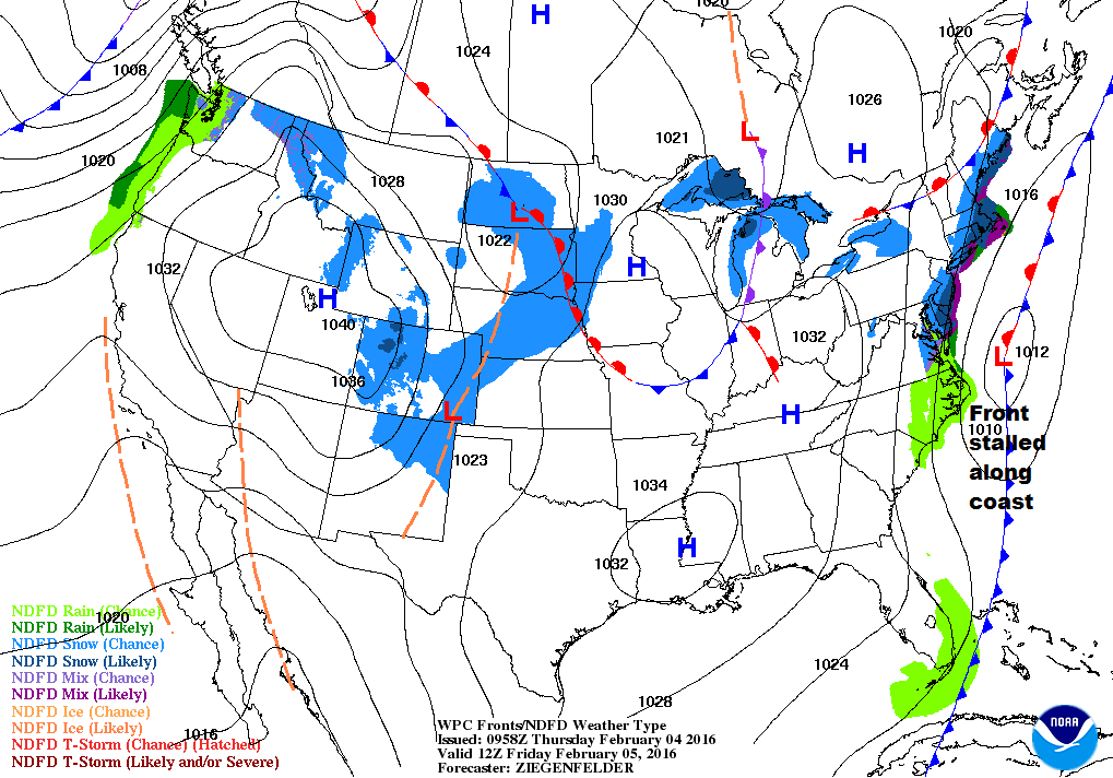
A couple of days ago it appeared the front would be about 100 miles farther east and therefore any renewed precipitation developing along it would stay out at sea. Now, with things slowing down, the front gets stuck closer to the coast and the precipitation is forecast to remain over the fish, and over eastern areas tomorrow morning.
Like nearly all weather systems that creep up on us, a slight shift back out to sea or farther west changes snow amounts. This is a coastal issue and won’t penetrate very far into the foothills, if at all.
Messy Friday morning commute
It should be snowing in Portland for the entire morning commute Friday which means a slow and messy drive to work. Fridays typically have lighter commuter traffic, but with the snow I expect a rough ride.
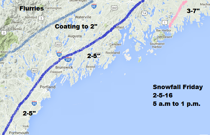
I don’t think schools see widespread cancellations because the snow won’t be very heavy and I’m not expecting over 6 inches. However, some areas might delay opening by an hour or two to allow for cleanup. Southern coastal areas are at the greatest risk for a snow day.
The snowfall map below will likely be modified late today when I get new information. I expect the lines to shift east or west depending on computer guidance and trends.
The weekend is looking very nice with sunshine and mild air for February. The fresh snow cover will prevent temperatures from reaching the 40s, but upper 30s with sunshine and light winds will still be quite tolerable.
Next week may bring another storm
There is a possible additional storm for Tuesday which is Primary Day. At present, it appears the southern half of New Hampshire, southern coastal Maine as well as coastal southern New England have the best chance of snow, but the storm is still five days away and a lot can change.
Much colder air coming
One thing that is looking more and more likely is a period of very cold air at the end of next week. Some models have temperatures falling to near zero around Valentine’s Day and remaining cold for three to five days. This will likely be one of the colder periods we’ll have seen in our relatively mild winter.
Copy the Story LinkSend questions/comments to the editors.

Success. Please wait for the page to reload. If the page does not reload within 5 seconds, please refresh the page.
Enter your email and password to access comments.
Hi, to comment on stories you must . This profile is in addition to your subscription and website login.
Already have a commenting profile? .
Invalid username/password.
Please check your email to confirm and complete your registration.
Only subscribers are eligible to post comments. Please subscribe or login first for digital access. Here’s why.
Use the form below to reset your password. When you've submitted your account email, we will send an email with a reset code.