


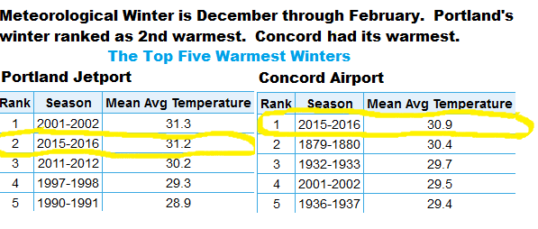
March in Maine is often a wintry month, but the coldest period known as meteorological winter is now over. With the winter season behind us, it’s time to review some of the numbers. The meteorological winter of 2015-2016 marks the second-warmest three-month period of December to February on record. The warmest was the winter of 2001-2002, but only by a small margin.
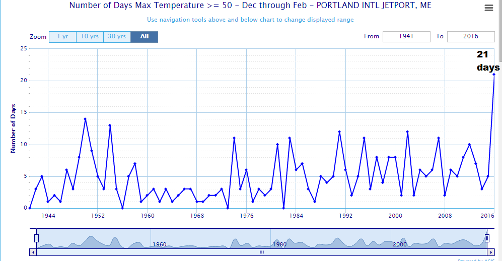
There were 21 days that reached 50 degrees or higher during this period. This was the most number of 50-plus days ever recorded during what meteorologists call winter and beat the previous record by seven, set back in 1949-1950. The chart below gives you an idea of how 50 degree days have occurred during the meteorological winter period since records moved to the Portland International Jetport in the 1940s.
The warmth was quite remarkable. Here’s another way to think of it. If you string the warmest days together into a month, we basically what should be one of those three coldest months of the year feel more like April. This is one of the reasons so many plants are already growing and, in some cases, periodically came out of dormancy.
QUICK-HITTING COLD
We did have one very cold stretch during Valentine’s weekend. Portland reached 10 below zero on Feb. 14 and 15, part of a string of four mornings below zero. The average temperature was nearly 25 degrees below average, for the most extreme day of February.
TYPICAL SNOWFALL
The snowfall is rather interesting, too. Of the 76 winters at the Portland International Jetport in the database, this winter was the 30th-least snowy; in other words, there are 29 other winters with less snow. You might find this surprising since it seems like we haven’t much snow at all. There were 41 inches of snow during the December to February timeframe.
Part of the reason this winter isn’t going to be remembered for snow or cold is because of the warmth. Even in winters with a lot of snow, if the ground periodically opens up, it gives all of us the feeling of a break in the action. Last winter, once the ground finally became snow covered, it didn’t open up in many areas until early April. This meant 10-12 weeks of white snow banks and a feeling of claustrophobia. When the snow is piled high, our available world shrinks. The impact to our collective psyche is palpable.
February snowfall was quite a bit above average with just about 20 inches having fallen in Portland. The 8.8 inches on Feb. 5 was the largest storm and may very well end up being the largest storm of the season.
The warmth is really the theme and why our ground is bare at the end of February in stark contrast to last year. On maps that show snowfall on the final day of meteorological winter this year and how it compares with roughly the same time last year, the differences are stark. Unfortunately, for many ski areas, that may mean an early end to what’s been a season filled with a lot of spring skiing, no matter what the calendar has said.
Send questions/comments to the editors.

Success. Please wait for the page to reload. If the page does not reload within 5 seconds, please refresh the page.
Enter your email and password to access comments.
Hi, to comment on stories you must . This profile is in addition to your subscription and website login.
Already have a commenting profile? .
Invalid username/password.
Please check your email to confirm and complete your registration.
Only subscribers are eligible to post comments. Please subscribe or login first for digital access. Here’s why.
Use the form below to reset your password. When you've submitted your account email, we will send an email with a reset code.