


Evening Update
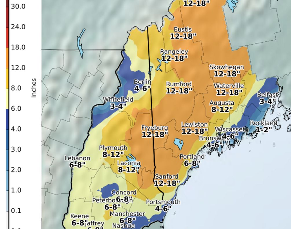
As of mid-evening the snow was still falling hard and fast across much of southern Maine. Snow totals will be significantly heavier than forecast over southern Maine. The rain-snow line never penetrated very far inland allowing most of the storm to produce snow. This means some totals of 12-20 inches are likely when all is said and done in those areas from Sanford up through Rumford. Even the immediate suburbs of Portland could exceed 6 inches of snow in total, including some of the snow which fell and was washed away.
Heavy snow will end before sunrise on Friday.
Afternoon Update
Snow has overspread the area this afternoon with heavy snow at times. The rain snow line continues to try to push west, but isn’t making much progress. The longer this process takes, the more snow that will result along the coast. For the higher ends of the snow totals to be reached, the rain needs to hold off through the early evening. As of 4 p.m the Jetport still had winds from the northeast and indication of cold air staying locked in a bit longer than expected.
Morning Update
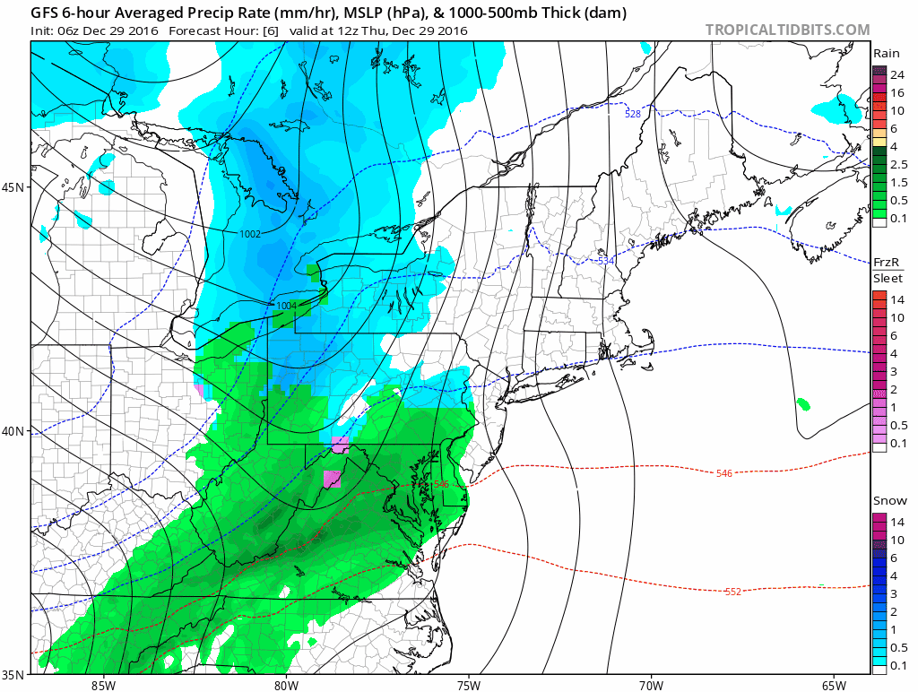
This morning a storm developing near Long Island in New York will move across southeastern New England later today and then intensify into a big storm over eastern Maine on Friday. When storms take this track, they bring precipitation, but also warmer air off the ocean. This means that although you will likely see some snow to start this morning, rain will be the predominant player in this storm along the coastline. The rain-snow line will move north, aligning around or near the Maine Turnpike. The line will then collapse back to the coast before the storm ends early Friday.
A storm will become intense over northern Maine Friday morning
If you live in interior Maine, there will a lot of snow. From Bridgton to Bethel onto Rumford, Sugarloaf and Greenville look for snow amounts of six inches to near a foot an a half. This is a boon for skiing on the final weekend of the school vacation week and a stark contrast to last winter when snow was sparse.
The snow will be heavy and wet close to the rain-snow line, but lighter and less wet further inland. I highly recommend trying to move it in small batches during the storm if you are shoveling. Some areas closest to the rain snow-line will have such wet snow a snowblower might not be able to throw the snow very far. Those areas that see a few inches of snow followed by rain will have a lot of slop to contend with on Friday. Fortunately, I am not expecting a hard freeze tonight and highs on Friday will go above freezing in many areas.
As the storm intensifies it will create more wind. There is a wind advisory for the coastal plain and a few scattered power outages are not out of the question. Further east there is a high wind warning. Winds in the warning area could gust over 50 miles per hour.
Precipitation moves into the area late this morning and exits from about 11 p.m to 4 a.m south to north. The rapid movement of the storm means a quick ending. Areas which do change to rain will change back to snow before the storm ends. There will be a coating of snow up to a few inches on the back end of the storm.
Friday and Saturday are dry with some rain and snow showers in the forecast late New Year’s Eve.
You can follow my forecast on Twitter @growingwisdom
Send questions/comments to the editors.

Success. Please wait for the page to reload. If the page does not reload within 5 seconds, please refresh the page.
Enter your email and password to access comments.
Hi, to comment on stories you must . This profile is in addition to your subscription and website login.
Already have a commenting profile? .
Invalid username/password.
Please check your email to confirm and complete your registration.
Only subscribers are eligible to post comments. Please subscribe or login first for digital access. Here’s why.
Use the form below to reset your password. When you've submitted your account email, we will send an email with a reset code.