

MIAMI — Florida officials urged residents in flood-prone coastal communities to get out while they can, ordering evacuations in the face of oncoming Hurricane Irma, which could make landfall Sunday and inflict massive destruction not seen in the state since Hurricane Andrew in 1992.
The National Hurricane Center in Miami issued hurricane warnings Thursday night for South Florida and the Keys, as the hurricane tracked toward the state with 165 mph winds.
Irma weakened from a Category 5 storm to Category 4 on Friday morning with maximum sustained winds near 155 mph, but it remained a powerful hurricane.
Irma was 585 miles east-southeast of Miami late Thursday. The Hurricane Center predicts severe conditions to begin Saturday in Florida.
Hurricanes have teased South Florida many times, but officials at the National Hurricane Center said this is shaping up as a once-in-a-generation storm. Forecasters adjusted their advisory late Thursday, projecting Irma to hit the tip of the peninsula, slamming the population centers of South Florida before grinding north.
“This storm has the potential to catastrophically devastate our state,” Gov. Rick Scott said in a late-day news briefing. Earlier, he implored people to evacuate. “If you live in any evacuation zones and you’re still at home, leave.”
The state’s highways were jammed, gas was scarce, airports were deluged and mandatory evacuations began to roll out as the first official hurricane watches were issued for the region. Irma, which has been ravaging the Caribbean islands as it sweeps across the Atlantic, is expected to hit the Florida peninsula with massive storm surges and crippling winds that could affect nearly every metropolitan area in South Florida.
The hurricane center said Thursday afternoon that should Irma’s eye move through the center of the state, extreme winds and heavy rains could strafe an area that has millions of residents, from Miami in the east to Naples on the Gulf Coast. Because the eastern side of the storm is the most powerful, numerous cities along the east coast could face extreme conditions.
Miami-Dade County ordered some mandatory evacuations, including for Key Biscayne and Miami Beach, as well as for areas in the southern half of the county that are not protected by barrier islands.
“EVACUATE Miami Beach!” Miami Beach Mayor Philip Levine tweeted, later noting in a news release that once winds top 40 mph, first responders will no longer be dispatched on rescue missions here.
Broward County Mayor Barbara Sharief said evacuations in coastal areas were slated for Thursday. Lee County, on the Gulf Coast, announced Thursday afternoon that all the barrier islands – Sanibel, Captiva, Pine Island, Bonita Beach and Fort Myers Beach – will be under mandatory evacuation orders Friday.
Scott has declared a statewide emergency and warned that in addition to potentially forcing large-scale evacuations, Irma could batter areas that last year were flooded by Hurricane Matthew. States of emergency also were declared in Georgia, South Carolina and North Carolina. On Thursday, Georgia Gov. Nathan Deal expanded his declaration from six coastal counties to 30 total counties, issuing a mandatory evacuation for some areas.
Residents in Savannah, Georgia, and Charleston, South Carolina, began to barricade their homes and flee the coast Thursday. Gov. Henry McMaster warned South Carolinians that a mandatory evacuation of the state’s coastline will probably come Saturday morning at 10 a.m. Such an evacuation would come with a reversal of all eastbound lanes of four major roadways, including Interstate 26, which would be converted for a westbound escape from Charleston to Columbia.
Irma on Thursday had hurricane-force winds extending 60 miles from its center. If the eye does not make landfall, many of the people who haven’t evacuated from South Florida could find themselves in hurricane conditions anyway, forecasters say.
This enhanced satellite image shows the expected location of the storms Katia in the Gulf of Mexico, Irma over the Caribbean islands and Jose at right, Thursday evening.
TIMING OF STORM’S TURN CRITICAL
Residents are closely watching the “the spaghetti” – the dozens of computer models showing possible storm tracks, which vary widely. Computer models say that by Sunday, Irma will make a hard right turn, heading due north into Florida.
The timing of that turn will make all the difference.
If sooner, the storm’s center could stay offshore, between Miami and the Bahamas. If later, it could blow through the Florida Keys and come up the southwest side of Florida. Or it could find a middle path straight up through the Everglades and the central spine of the peninsula.
“The wild card here is the turn. Anytime a hurricane makes a turn it introduces uncertainty,” Mark DeMaria, acting deputy director of the National Hurricane Center in Miami, told The Washington Post in the center’s headquarters in west Miami-Dade County. He noted that the computer models have fluctuated modestly, with adjustments in the consensus track of only 50 miles or so every day. “But 50 miles onshore versus right of the coast makes a huge difference in impact,” he said.
The combination of Florida’s geography, the pattern of urban settlement in narrow bands along the coasts and the projected northerly path of the hurricane presents a particularly ominous picture.
This satellite image taken Thursday shows the eye of Hurricane Irma, center, just north of the island of Hispaniola, with Hurricane Katia, left, in the Gulf of Mexico and Hurricane Jose, right, in the Atlantic Ocean.
“This is a large storm coming from the south,” said Dennis Feltgen, spokesman for the hurricane center. “That’s the worst-case scenario because it takes in the entire Gold Coast population and you have the greatest impact from storm surge from that direction.”
Irma’s sustained winds were the strongest recorded for an Atlantic hurricane making landfall, tied with the 1935 Florida Keys hurricane.
“Look at the size of this storm,” Gov. Scott said. “It’s powerful and deadly.”
Many Floridians were heeding warnings to escape but found themselves sitting in bumper-to-bumper traffic in an effort to reach points north.
A little after 10 a.m. at the National Hotel on Miami Beach, a manager announced in four languages – English, Spanish, Portugeuse and French – that guests needed to evacuate because of a city order. At the front desk, guests were given a sheet listing the locations of emergency shelters, none of which were likely to be as nice as the beachfront Art Deco hotel, which was restored a few years ago.
“This morning as I walked to work I could see the things that could become projectiles,” said Natalya Garus, 35, lead concierge at the National. “Street signs. Coconuts. All the trash cans. Smoking stations. All the decorations.”
As she spoke, workers used a ladder to dismantle a decorative light fixture hanging over the hotel entrance.
Ruben Vandebosch, 28, and Wim Marten, 26, both of Belgium, and Jim Van Es, 24, of the Netherlands, said their plan is to drive to Atlanta.
“Atlanta has a nice ring to it,” Vandebosch said. “It sounds cool.”
Among those evacuating: Forty dogs from the Miami-Dade County animal shelter. They’re being flown to New York on a private plane owned by a dog lover named Georgina Bloomberg, according to Lauree Simmons, president and founder of the Big Dog Rescue shelter in Loxahatchee, Florida.
Big Dog staff went to Houston after Hurricane Harvey, rescuing 60 dogs from the floodwaters. Those dogs are awaiting adoption at the no-kill shelter. Simmons’s 33-acre rescue center has 457 dogs and puppies living in air-conditioned bunkhouses. Staff members were working frenetically Thursday packing up the contents of offices trailers. The dog bunkhouses, meanwhile, are fitted with hurricane impact glass built to withstand 200-mile-an-hour winds, Simmons said.
“The dogs will be very comfortable,” she said. “We’ll stay here with them through the storm, and just keep hoping for the best.”
This photo provided by the Dutch Defense Ministry shows storm damage Thursday in St. Maarten in the aftermath of Hurricane Irma. Significant damage was reported on the island, which is split between French and Dutch control.
HOPING FOR THE BEST, PREPARING FOR THE WORST
Popular shopping and dining areas of Fort Lauderdale, north of Miami, were nearly completely empty, the businesses buttoned up with metal curtains and new plywood protecting their front windows.
At the Coral Ridge Yacht Club on the Intracoastal Waterway, General Manager Jay Wallace and Greg Bennett, the club’s president, were walking up and down its docks making sure all the vessels, including some 90- and 100-footers valued at $2 million or more, were securely tied down. The club decided Tuesday to cease regular operations – meetings, lunch, dinner and a popular Wednesday happy hour – so that many employees would have time to evacuate.
“Just making sure everything is okay,” Wallace said. “We’re hoping for the best, but preparing for the worst. You have to.”
Less than a mile away, Fort Lauderdale’s mostly spotless sandy beaches were virtually deserted, despite the green flags attached to all its lifeguard stands indicating “low hazard” for anyone wanting to take a dip in the ocean. The water was dead calm, not a wave in sight, and the shimmering sand was desolate on a postcard 90-degree day.
In Orlando, four Stetson University students prepared to fly out of town on cheap tickets bought Monday, before prices skyrocketed and seats vanished. One of the students, Draven Shean, is a freshman who has been at school for three weeks and is heading home to Houston, where his family had evacuated in advance of Hurricane Harvey.
“I keep making this joke that God keeps sending hurricanes after me,” said Shean, who was wearing a long-sleeved gray shirt with black block letters that said “EVAC.” He picked it up two days ago at a thrift store. “I thought it was appropriate.”
SEARCHING FOR GAS
Others were preparing to ride out the storm. Some were fully prepared, others seemed to have only a vague plan, or none at all.
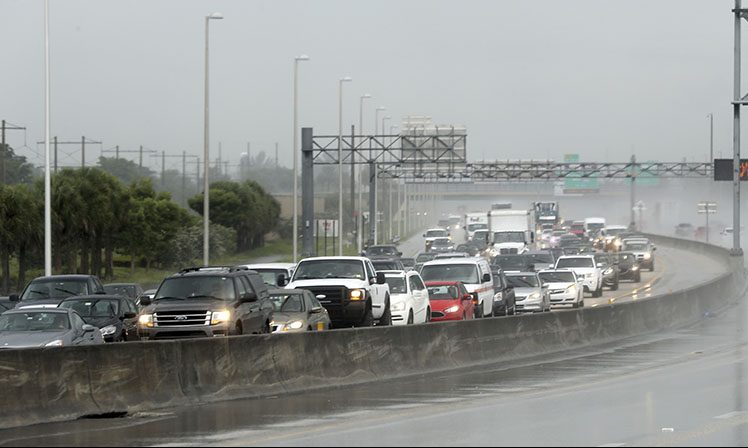
Northbound traffic on Interstate 75 through Sarasota, Fla., was heavier than normal Thursday but still moving. Many South Florida residents are evacuating and heading north as Hurricane Irma approaches.
At a Costco in Naples, in southwest Florida, almost every morning shopper left the store with a flat or two of bottled water. At Costco’s gas station, vehicles jammed the six lanes for fuel. Several customers said the 24 cars waiting at 11 a.m. were nothing compared with the lines during the past two days. Some customers were on their third or fourth gas station seeking to fill up.
“As soon as they said you should consider evacuating, things got way worse,” said Michelle Anderson, who was waiting for gas in her Volvo. “I’m from Southern California, where earthquakes get you at random, so the fact that you have the ability to prepare for this is pretty awesome.”
Vicki Sargent, a Florida resident since 2003, lives in an RV park in Venice and had driven miles in search of gas Thursday. She said she has to ride out the storm because she takes care of about 70 units owned by people gone for the summer. She won’t stay in her own trailer, though.
“Only a fool would do that,” she said, saying she’ll stay with a friend. “I’m more worried about flooding than the hurricane. We have had rain and were about at saturation point.”
Tatiana Wood, 33, a waitress at a restaurant in Miami Beach’s Lincoln Road Mall, said she has a friend of a friend who lives in Oklahoma, but she was unclear of the distance or whether she’d try to get there.
“If you try to escape, you may lose money,” Wood said. “If you stay, you might lose your life.”
IRMA’S PLACE IN HISTORY
• Irma’s peak intensity (185 mph) ranks among the strongest in recorded history, exceeding the likes of Katrina, Andrew and Camille – whose winds peaked at 175 mph.
• Among the most intense storms on record, it only trails Hurricane Allen in 1980, which had winds of 190 mph. It is tied for second most intense with Hurricane Wilma in 2005, Hurricane Gilbert in 1988 and the 1935 Florida Keys hurricane.
• The storm has maintained maximum wind speeds of at least 180 mph longer than any other storm on record in the Atlantic or Pacific Ocean.
• Late Tuesday night, its pressure dropped to 914 millibars (the lower the pressure, the stronger the storm), ranking as the lowest of any storm on record outside the Caribbean and Gulf of Mexico in the Atlantic basin.
• The storm has generated the most Accumulated Cyclone Energy, a measure of both a storm’s duration and intensity, of any hurricane on record.
• Without a doubt, the World Meteorological Organization will retire the names Harvey and Irma after this season. While there have been several instances of consecutive storm names getting retired (Rita and Stan 2005, Ivan and Jeanne 2004, Isabel and Juan 2003, Luis and Marilyn 1995), the U.S. has only been hit by more than one Category 4+ hurricane in a season one time: 1915. Two Category 4 hurricanes hit in Texas and Louisiana six weeks apart that year.
Credit to tropical weather expert and occasional The Post’s Capital Weather Gang contributor Phil Klotzbach for some of the statistics in this section.
HURRICANE SEASON UPDATE
We are nearing the halfway point of the hurricane season in terms of overall activity, and this season has ranked almost double what’s normal (183 percent of average). This is largely due to the massive contribution from Irma, but also from Harvey as well as recent additions Jose and Katia. The June outlooks for an above-average season will almost certainly verify at this rate.
IN OTHER STORM NEWS
• U.S. airlines capped ticket prices for passengers fleeing the hurricane.
• American Airlines canceled 2,185 flights Thursday through Monday and will stop all flights from Miami and three other Florida cities Friday afternoon, the airline said in an email statement.
• Insurers including Progressive and Allstate stopped issuing policies on new cars in some Florida counties.
Credit to Bloomberg News for this section.
Send questions/comments to the editors.

Success. Please wait for the page to reload. If the page does not reload within 5 seconds, please refresh the page.
Enter your email and password to access comments.
Hi, to comment on stories you must . This profile is in addition to your subscription and website login.
Already have a commenting profile? .
Invalid username/password.
Please check your email to confirm and complete your registration.
Only subscribers are eligible to post comments. Please subscribe or login first for digital access. Here’s why.
Use the form below to reset your password. When you've submitted your account email, we will send an email with a reset code.