

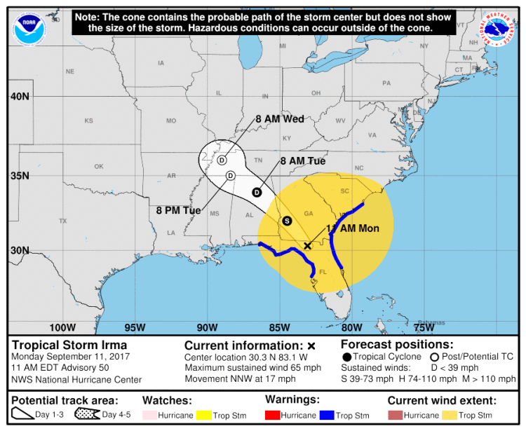
Tropical Storm Irma is gradually losing its strength as it sloshes through northern Florida with the National Hurricane Center discontinuing four storm surge and tropical storm warnings.
Irma’s maximum sustained winds were down to 65 mph as the storm was about 70 miles east of Tallahassee late Monday morning. It’s moving north northwest at 17 mph.
Forecasters expect Irma’s center to move into southwestern Georgia later Monday and then into Alabama Tuesday morning and eventually western Tennessee.
Northern Florida and southern Georgia are expected to keep getting soaked, with rain totals eventually accumulating to 8 to 15 inches. Isolated parts of central Georgia, eastern Alabama and southern South Carolina may get up to 10 inches of rain.
North Carolina Gov. Roy Cooper said Monday the threat in his state remains the greatest in the mountains, with localized flooding and power outages possible.
Cooper said the threat for rockslides in western North Carolina is greater this year because of mountain wildfires last fall.
There could also be minor flooding at the coast. Heavy rain and high winds should begin in the state Monday afternoon and continue until early Tuesday.
North Carolina remains in a state of emergency, with staging areas for recovery operations in Greensboro, Charlotte and Asheville.
Duke Energy said it has 4,500 workers stationed in the Carolinas to respond to power outages.
Send questions/comments to the editors.

Success. Please wait for the page to reload. If the page does not reload within 5 seconds, please refresh the page.
Enter your email and password to access comments.
Hi, to comment on stories you must . This profile is in addition to your subscription and website login.
Already have a commenting profile? .
Invalid username/password.
Please check your email to confirm and complete your registration.
Only subscribers are eligible to post comments. Please subscribe or login first for digital access. Here’s why.
Use the form below to reset your password. When you've submitted your account email, we will send an email with a reset code.