

Pretty soon the skis will be out and the canoe hidden under a blanket of snow in the backyard. But not quite yet. Some of the best paddling of the year can occur in November if you hit the weather just right.
A nice place to enjoy the last vestiges of fall color is Chewonki Neck in Wiscasset. The neck forms part of the western shoreline of the Back River and juts out into Montsweag Bay just west of Westport Island. And if you want to see bald eagles any time of year, this is the place.
Additional Photos
You can access the neck from two boat launch sites on opposite sides of the Back River, each a mile south of the Route 144 bridge leading over onto Westport Island. Consult the DeLorme Maine Atlas and Gazetteer (map #7).
Following along the western shore of the Back River you will paddle by remnant buildings and utility towers of the former Maine Yankee. The steep banking is covered with oak and beech, providing dazzling yellows and browns against a blue sky. A few late-season sandpipers fly along the shore ahead of us. After two miles of exploring you will veer more westerly across the mouths of two long, narrow coves. These two coves each stretch northward for a mile and offer secluded paddling. We pass by these options and continue on for the third cove, just to the west of Chewonki Neck and north of Oak Island.
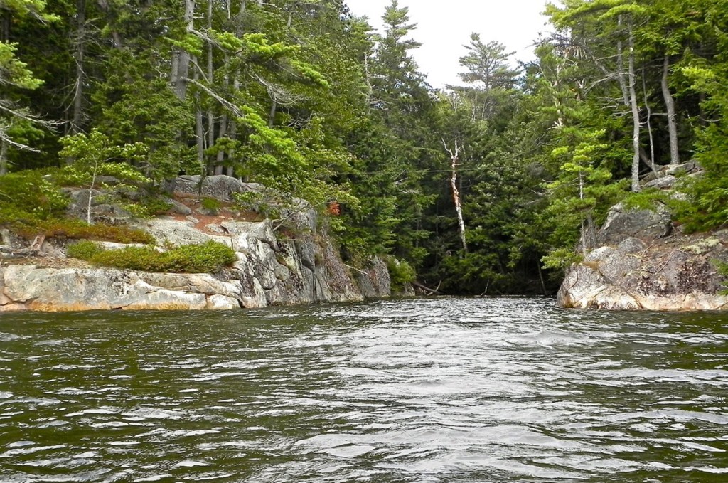
At the tip of Chewonki Neck, a big cut in the rock has created a magnificent rectangular cove that you can paddle 40 yards back into.
With walls rising above you 20 feet and evergreens leaning out over the water, you are hidden from the world in the shadowy darkness while gazing out into the brilliant light of the open bay.
We head north up toward the bay bordering the western side of Chewonki Neck. A small island marks the narrow opening into the bay.
Passing by the waterfront facility of the Chewonki Foundation, we paddle out into a broad marsh lined by golden brown grasses. Many fingers of water stretch out into the grasses, making for an endless variety of exploring at high tide. To the north, mown fields and lawns still radiate an emerald green. Some of those fields are part of Chewonki Campground, now closed for the season.
We paddle under the Maine Eastern Railroad tracks through an impressive oval tunnel (check out the echo in the tunnel) and gain access into a smaller marsh leading up to Route 1 and a green sign marking the border of Lincoln County.
A bald eagle, with a sudden rush of wings, springs up from the brush on our left. A blue heron then circles the cove and heads up to a perch in the trees. Two cormorants stand precariously on the branch ends of a snag in the middle of the stream.
The 4-foot high waterfall tumbling under the Route 1 bridge ends our upstream exploration. Curious about where we were relative to Route 1, we scramble up the steep, brush-choked banking to check things out. A hundred yards away stands the Montsweag Roadhouse. Too bad we left our money back in the car – we would have to stick with our peanut butter and jelly sandwiches.
It’s time to start the 5-mile paddle back to the boat launch on Westport Island. This is where consulting the weather forecast beforehand is important. Plan this outing for a calm day. You should not be paddling out in the open waters of the Back River if the forecast calls for southerly winds. The convoluted land masses help accelerate any southerly winds, and the resultant chop coupled with a midtide river current can make paddling an open canoe difficult. Light winds from the northwest or west are preferable. Paddlers should be experienced in paddling in moving water.
Michael Perry is the former director of the L.L. Bean Outdoor Discovery Schools, and founder of Dreams Unlimited, specializing in inspiring outdoor slide programs for civic groups, businesses, and schools.michaelj_perry@comcast.net
Send questions/comments to the editors.

Success. Please wait for the page to reload. If the page does not reload within 5 seconds, please refresh the page.
Enter your email and password to access comments.
Hi, to comment on stories you must . This profile is in addition to your subscription and website login.
Already have a commenting profile? .
Invalid username/password.
Please check your email to confirm and complete your registration.
Only subscribers are eligible to post comments. Please subscribe or login first for digital access. Here’s why.
Use the form below to reset your password. When you've submitted your account email, we will send an email with a reset code.