

Geocaching is hiking through the woods in search of something you never lost.
It’s also a treasure hunt of sorts, even if the so-called treasure is nothing more than the opportunity to say “I was here” in a small logbook.
Additional Photos
Less than a decade old, the high-tech hide-and-seek game has lured people into parks, down dirt roads and into well traveled city squares around the world. They’re searching for a geocache — typically a lunchbox-sized container with a logbook inside and sometimes other booty like small trinkets or toys.
The discoveries aren’t exactly what the sword-swinging pirates of history were usually after, but geocaching is less about the plunder and more about the pilgrimage.
The ragged-edged treasure map of yesteryear has been replaced by a GPS (global positioning system), which uses satellite technology that’s accurate to within 9 feet and doesn’t smudge the navigational hints under dirty pirate fingers.
My colleague Wendy Almeida and her two daughters, all well versed in the game, offered to take me on my first geocaching adventure, up the steep inclines of Camden Hills State Park.
Cache locations are listed on a variety of international sites, such as geocaching.com. Members are able to set up profiles, post cache locations of their own, gather the coordinates for hidden caches and post their experiences (“Great cache!” Or sometimes, “Did not find.”)
Since I’d never toyed with a GPS before, Almeida handed over her device and allowed me to enter in the latitude and longitude coordinates for the half-dozen caches on our list for the day. The technology used by handheld receivers is the same that enables your in-car Garmin to tell you to “turn right in 800 feet,” though off-road meandering is less precise. Users are unlikely to hear their receiver whisper among the overlooking trees, “Follow dirt trail to big rock. Turn left.”
In my hand, the contraption felt like a clunky cell phone of decades past. I scrolled through the icons on the small screen — “Mark” and “Tracks” and “Proximity” — and realized this is what it must feel like when my technology-avoiding father tries to make a phone call with his new BlackBerry, especially when I had to be corrected for holding it upside down.
With our impending destinations entered, we swung our backpacks over our shoulders and started up Megunticook Trail toward the top of the mountain.
On a zigzagging trail, a blend of compass-following and common sense is in order. The GPS may point northwest, while the marked trail bends east. But the trail map indicated we’d end up where we needed to be, so there was no inclination to dive headlong into the woods, especially in a state park where bushwhacking is discouraged.
After a few trail stops to drink some water, I saw the GPS was finally giving distance in feet rather than miles. Onward we clambered, up the steep staircase of rocks leading to the mountain’s peak. Finally the trees gave way to open sky and our exhausted legs felt the relief of a flat landing.
The cache we’d fought gravity to find was called Shaping the Hills. Unlike traditional container-based geocaches, Shaping the Hills is an EarthCache. The intent is to locate a unique geological feature rather than a hidden box.
The EarthCache description directed us to glacial striations scarring the rocky top of the mountain. “The passing of the glacier some 22,000 years ago finally shaped the mountains in the park. … Glacial striations or glacial grooves are scratches or gouges cut into bedrock by process of glacial abrasion.”
Sure enough, as the digits on the GPS dropped into the teens, we could see an array of shallow scratches in the rock — like Mother Nature’s scraped knee. I’d been to Mount Megunticook’s peak in the past. And I’d spent ample time loitering in the open air, watching specks of boats in Camden Harbor below. I’d followed the dipping and soaring of a hawk in the valley between mountains and I’d let my gaze stretch over the seemingly endless rolling green to the west. But I’d never noticed the lines under my feet, a glacial signature left thousands of years ago when this mountain was draped in ice rather than heavy summer sun.
It was an education in natural history — and a successful first EarthCache. With no logbook available to sign, we snapped photos of ourselves at the location as evidence we’d been there.
I was also still itching for man-made loot. So we bid farewell to the views from Mount Megunticook and made our way back toward sea level.
The low-lying hike didn’t last long, since our next destination, neighboring Mount Battie, led us back up. As the trail altitude grew, my eyes repeatedly returned to the distance counting down on the GPS receiver.
There were no riches awaiting us, tucked behind a tree or under the foliage. But I felt a similar enthusiasm, a thrill of the hunt for a waterproof container in the woods. It was enough to balance the soreness I knew would find my calves by morning.
The GPS registered 30 feet. Then 20. Then single digits. A few more strides and the number on the screen began ticking upward again. We’d passed it.
I turned to retrace my path, walking slowly to give the satellite signals time to register with the receiver. The directional arrow pointed just off trail. After a few years of use, Almeida knew her GPS receiver wasn’t going to lead us to within inches of the geocache. Instead, we relied on our own powers of deduction. Mostly, we looked.
My eyes darted over the greenery, seeking a rectangular shape not typically found in nature. With my foot, I nudged a few rocks. I snuck up on a few trees, expecting to find a cache tucked behind their backs.
After a few minutes went by and my investigation had led to the discovery of several thick spider webs, but no cache, Almeida passed along some hints.
“Try looking under things like piles of sticks,” she said. “Things that look like they might have been moved around a little.”
And there, a few feet away, was a loosely stacked mound of branches and a dark green box revealing itself from beneath them. “I found it!” I called, only then realizing that Almeida and her daughters were patiently standing by, letting me claim first discovery even though they’d probably known it was there all along. They are experienced geocachers, after all.
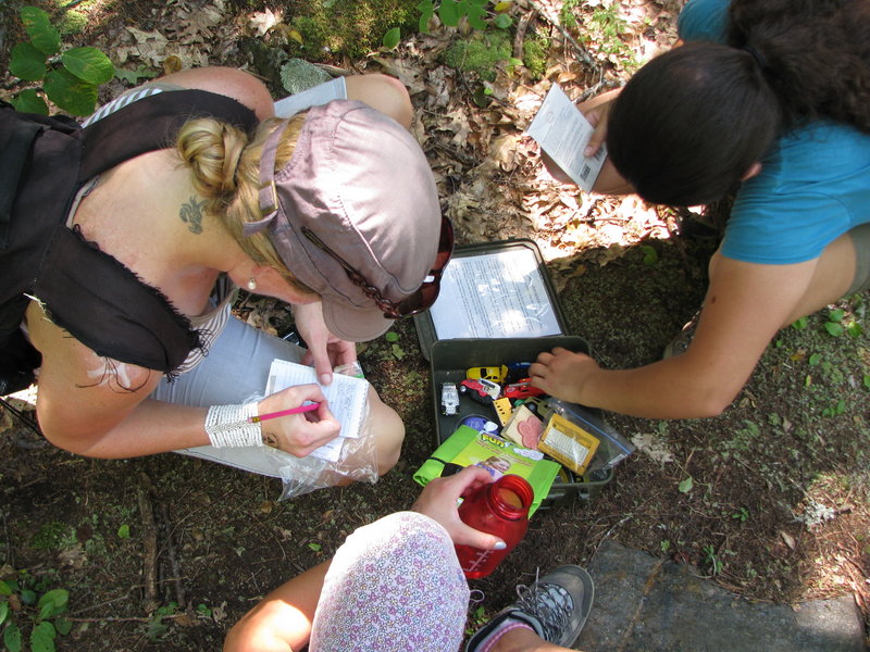
I tugged the small ammo box from under its camouflage and opened it to reveal the goodies inside: A small logbook and pencil, toy cars and trinkets, a craft bag and other items. There was no gold. No bejeweled crown. No skeletal hand clutching an ancient chalice.
But I still felt like a treasure-seeker who’d found her treasure.
Staff Writer Shannon Bryan can be contacted at 791-6333 or at:
sbryan@mainetoday.com
Send questions/comments to the editors.

Success. Please wait for the page to reload. If the page does not reload within 5 seconds, please refresh the page.
Enter your email and password to access comments.
Hi, to comment on stories you must . This profile is in addition to your subscription and website login.
Already have a commenting profile? .
Invalid username/password.
Please check your email to confirm and complete your registration.
Only subscribers are eligible to post comments. Please subscribe or login first for digital access. Here’s why.
Use the form below to reset your password. When you've submitted your account email, we will send an email with a reset code.