

Updated at 8:45 a.m.
MIAMI — Forecasters say Sandy has again reached hurricane strength, with sustained winds of 75 mph.
Additional Photos
The National Hurricane Center in Miami said Saturday morning that a Hurricane Hunter aircraft found Sandy had sustained winds powerful enough to upgrade it to a Category 1 hurricane. It had been downgraded to a tropical storm just hours earlier.
Regardless of its official category, Sandy is expected to be a monstrous storm that poses a serious threat for the entire Eastern Seaboard.
Forecasters say Sandy is a massive cyclone, with hurricane-force winds recorded as far as 100 miles away from the eye of the storm.
Tropical storm conditions could be felt in the Carolinas by Saturday evening.
BLOOMSBURG, Pa. — Douglas Jumper choked up as he described the long, slow recovery in his central Pennsylvania town from last year’s historic flooding caused by Hurricane Irene and the remnants of Tropical Storm Lee — and contemplated the possibility of yet more damage from an approaching storm.
“I’m tired. I am tired,” Jumper, who turned 58 on Saturday, said through tears. “We don’t need this again.”
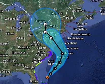
Jumper’s town of Bloomsburg, and much of the Eastern Seaboard, was in the path of a rare behemoth storm barreling north from the Caribbean. Tropical Storm Sandy was expected to make landfall early Tuesday near the Delaware coast, then hit two winter weather systems as it moves inland, creating a hybrid monster storm that could bring nearly a foot of rain, high winds and up to 2 feet of snow.
Experts said the storm could be wider and stronger than Irene, which caused more than $15 billion in damage, and could rival the worst East Coast storm on record.
Jumper’s first floor took on nearly 5 feet of water last year, and he was busy Friday moving items from his wood shop to higher ground.
Up and down the coast, people were cautioned to be prepared for days without electricity. Jersey Shore beach towns began issuing voluntary evacuations and protecting boardwalks. Atlantic City casinos made contingency plans to close, and officials advised residents of flood-prone areas to stay with family or be ready to leave. Several governors declared states of emergency. Airlines said to expect cancellations and waived change fees for passengers who want to reschedule.
“Be forewarned,” Connecticut Gov. Dannel P. Malloy. “Assume that you will be in the midst of flooding conditions, the likes of which you may not have seen at any of the major storms that have occurred over the last 30 years.”
At a Home Depot in Freeport, on New York’s Long Island, Bob Notheis bought sawhorses to put his furniture on inside his home.
“I’m just worried about how bad it’s going to be with the tidal surge,” he said. “Irene was kind of rough on me and I’m just trying to prepare.”
After Irene left millions without power, utilities were taking no chances and were lining up extra crews and tree-trimmers. Wind threatened to topple power lines, and trees that still have leaves could be weighed down by snow and fall over if the weight becomes too much.
New York City began precautions for an ominous but still uncertain forecast. No decision had been made on whether any of the city’s public transportation outlets would be shut, despite predictions that a sudden shift of the storm’s path could cause a surge of 3 to 6 feet in the subways.
The subway system was completely shuttered during Irene, the first such shutdown ever for weather-related reasons. Irene largely missed the city, but struck other areas hard.
In upstate New York, Richard Ball was plucking carrots, potatoes, beets and other crops from the ground as quickly as possible Friday. Ball was still shaky from Irene, which scoured away soil, ruined crops and killed livestock.
Farmers were moving tractors and other equipment to high ground, and some families pondered moving furniture to upper stories in their homes.
“The fear we have a similar recipe to Irene has really intensified anxieties in town,” Ball said.
The storm loomed a little more than a week before Election Day, while several states were heavily involved in campaigning, canvassing and get-out-the-vote efforts. Republican presidential nominee Mitt Romney and Vice President Joe Biden both canceled weekend campaign events in coastal Virginia Beach, Va., though their events in other parts of the states were going on as planned. In Rhode Island, politicians asked supporters to take down yard signs for fear they might turn into projectiles in the storm.
Sandy, which the National Weather Service was calling a “very large tropical cyclone” early Saturday, killed more than 40 people in the Caribbean, wrecked homes and knocked down trees and power lines.
Early Saturday, the storm was about 155 miles north of Great Abaco Island in the Bahamas and 350 miles south-southeast of Charleston, S.C. Its sustained wind speed dropped below 70 mph, which downgraded the storm from hurricane strength.
Tropical storm warnings were issued for parts of Florida’s East Coast, along with parts of coastal North and South Carolina and the Bahamas. Tropical storm watches were issued for coastal Georgia and parts of South Carolina, along with parts of Florida and Bermuda.
Sandy was projected to hit the Atlantic Coast early Tuesday. As it turns back to the north and northwest and merges with colder air from a winter system, West Virginia and further west into eastern Ohio and southern Pennsylvania are expected to get snow. Forecasters were looking at the Delaware shore as the spot the storm will turn inland, bringing 10 inches of rain and extreme storm surges, said Louis Uccellini, environmental prediction director for the National Oceanic and Atmospheric Administration.
Up to 2 feet of snow was predicted to fall on West Virginia, with lighter snow in parts of Ohio and Pennsylvania. A wide swath of the East, measuring several hundreds of miles, will get persistent gale-force 50 mph winds, with some areas closer to storm landfall getting closer to 70 mph, said James Franklin, forecast chief for the National Hurricane Center in Miami.
“It’s going to be a long-lasting event, two to three days of impact for a lot of people,” Franklin said. “Wind damage, widespread power outages, heavy rainfall, inland flooding and somebody is going to get a significant surge event.”
Jeff Masters, meteorology director of the forecasting service Weather Underground, said this could be as big, perhaps bigger, than the worst East Coast storm on record, a 1938 New England hurricane that is sometimes known as the Long Island Express, which killed nearly 800 people.
Send questions/comments to the editors.

Success. Please wait for the page to reload. If the page does not reload within 5 seconds, please refresh the page.
Enter your email and password to access comments.
Hi, to comment on stories you must . This profile is in addition to your subscription and website login.
Already have a commenting profile? .
Invalid username/password.
Please check your email to confirm and complete your registration.
Only subscribers are eligible to post comments. Please subscribe or login first for digital access. Here’s why.
Use the form below to reset your password. When you've submitted your account email, we will send an email with a reset code.