

People were quick to ridicule the Portland Fire Department after the city’s new $3.2 million fireboat ran aground Nov. 7 in the passage between Cushing and Peaks islands.
The grounding caused $90,000 in damage, and sarcastic mariners said it was unlikely that the fireboat had hit a ledge that had gone unnoticed in Casco Bay for the past 300 years.
Additional Photos
Some, however, were less quick to judge.
Phineas Sprague, owner of Portland Yacht Services, has spent his life on the water off Maine’s coast, particularly in Portland Harbor. He was so shocked when his sailboat hit bottom in Whitehead Passage in 2007 that he hired a diver to investigate.
“I’ve been going through that all my life, and it’s like my home harbor had jumped up and bit me,” he said, recalling the incident and the embarrassment.
The diver found a sharp spine of ledge that protruded from the shore of Cushing Island beyond any marker, then dropped off suddenly.
“The diver told me there was red paint all over it, bottom paint from different boats,” Sprague said.
On Nov. 7, Portland firefighters were trying to rescue an elderly man who had fallen into frigid water off Jewell Island and then made it to shore.
The Coast Guard had already grounded one of its rescue boats during the astronomically low tide, and firefighters had intentionally grounded a skiff on the island’s shore.
The fireboat crew faced a challenging technical rescue that required more personnel to get the man from the rocky shore to the boat, so firefighter-paramedic Richard Wurfel, a licensed captain, headed back to Portland for more firefighters.
Maneuvering the two-month-old boat by instruments in the dark, Wurfel entered the passage just north of the fixed green daymark that denotes the southern side of the channel.
He was in a hurry.
The boat hit hard.
Chunks were taken out of the propellers, supports broke, and a softball-sized hole was punched in the hull.
Skeptical sailors assumed that the grounding had occurred outside the channel, and scoffed at the assertion that the fireboat was inside the marked waterway.
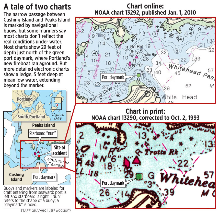
But Roger Long, a naval architect and harbor master for Cape Elizabeth, wrote an article for Points East sailing magazine revealing how the phantom ledge is not so far-fetched after all, and is in fact noted on some charts.
“I’ve been all over the coast of Maine, and that’s one of the biggest discrepancies I’ve seen,” Long said.
Long has seen the rock around the green marker at low tide, but never thought to compare its location with the chart.
“I always thought electronic charts and paper charts were exactly the same,” he said. He learned they’re not.
As it turns out, the information loaded into Global Positioning System navigation aids isn’t necessarily the most recent, detailed information available, he said.
All but the most up-to-date electronic charts show a 29-foot drop-off at the site of the marker, rather than the ledge extending into the channel just 5 feet below the surface at low tide.
Long said it’s not unreasonable to think that the protrusion of ledge would get little notice.
Whitehead Passage is used by far fewer large boats than the main channel into Portland, and the fireboat would rarely pass through it.
But on Nov. 7, the passage was the quickest way for the fireboat to get back to the city’s waterfront from uninhabited Jewell Island.
Long said that while he doesn’t know specifics about the fireboat grounding, the presence of unmarked ledge doesn’t fully excuse the pilot.
“Going through (a) channel that fast at night … he was on the wrong side of the channel. As a sailor, I’d say you screwed up,” Long said. “You’re not supposed to be following the little cursor around the GPS like a video game.”
Sprague said that when his boat hit the ledge, he was paying attention to his surroundings and was perhaps 4 to 5 feet inside his usual course through the passage.
“I don’t think I was being sloppy by the chart, but it didn’t occur to me the harbor that was the center of the North Atlantic fleet in World War II wouldn’t have the correct markings,” he said.
“We tend to blindly believe all of the stuff we’ve got in front of us and trust other people that, when they made the charts, they didn’t make an error,” he said.
Sprague alerted the National Oceanic and Atmospheric Administration about the discrepancy in 2007. The marker was moved, though only slightly, and the latest charts more accurately describe the bottom there, he said.
The Coast Guard checked the navigational markers after the fireboat’s accident and determined they were all in the correct locations.
Fire Chief Fred LaMontagne said he plans to meet with the Coast Guard to discuss improvements to the markers in that area.
“Individuals navigating inside a channel have a reasonable expectation that it will be hazard-free,” he said.
Staff Writer David Hench can be contacted at 791-6327 or at:
dhench@pressherald.com
Send questions/comments to the editors.

Success. Please wait for the page to reload. If the page does not reload within 5 seconds, please refresh the page.
Enter your email and password to access comments.
Hi, to comment on stories you must . This profile is in addition to your subscription and website login.
Already have a commenting profile? .
Invalid username/password.
Please check your email to confirm and complete your registration.
Only subscribers are eligible to post comments. Please subscribe or login first for digital access. Here’s why.
Use the form below to reset your password. When you've submitted your account email, we will send an email with a reset code.