

The Moose Pond Association is looking for a few good volunteers to help combat a degrading water quality situation. If you’re a resident of the area, you likely received a postcard recently regarding the upcoming erosion survey. More than 1,400 were mailed.
Picturesque Moose Pond lies at the foot of Pleasant Mountain and includes the towns of Sweden, Bridgton and Denmark. Its waters ultimately flow into the Saco River.
Additional Photos
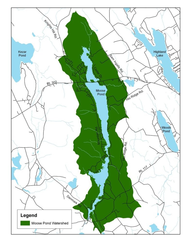
To help ensure water quality here, several environmental organizations will join forces May 8, for an erosion survey seeking to map out the over 11,000 acres that encompass the Moose Pond watershed.
A CHANGED WATERWAY
The Pond looks a bit different than it did before Europeans arrived. In 1792 a wooden dam was built by Cyrus Ingalls Sr. to float logs to the Saco and on to the Atlantic Ocean. Canoeing the shore in some stretches you can still see the remnants of massive pine stumps where the area was once forested.
In the 1830s, when early roadways were laid out, the long pond was a significant obstruction in creating a road from Bridgton to Fryeburg. The first wooden bridge was built at the site of the present causeway at Route 302. Over the years repairs and improvements seem to have slowly raised the level of the bridge. the 1920s, the demands of automobiles required a much more substantial structure; more rocks were dumped in as fill. A major upgrade in 1952 created the present causeway, with one portion still a bridge, essentially as it is today.
The pond has a surface area of 1,617 acres and with a mean depth of 20 feet and a maximum depth of 70 feet. Despite its relatively shallow mean depth, Moose Pond supports a population of landlocked salmon in the deeper sections.
PHOSPHORUS AND OXYGEN
Thanks to Lakes Environmental Association, water quality data has been gathered here since the 1970s. The LEA will join forces with the more recently formed Moose Pond Association and the Cumberland County Soil and Water Conservation District for the survey.
“We just need to get a snapshot of what’s going on in terms of erosion,” said Heather True, project manager with Cumberland County Soil and Water. “We’re non-regulatory. The next step would be securing federal and state funding to remedy any sites that are identified.”
With many dirt roads surrounding the pond, phosphorus is entering the lake with each soaking rain, degrading water clarity as well as oxygen levels at lower depths, an important requirement for a functioning salmon habitat.
Fishing is a big part of the culture on Moose Pond today. The pond has two public boat launches located on Route 302 in Bridgton and one way down on the southern end off the Lake Road in Denmark. Highly valued for its large and smallmouth bass fishery, Moose Pond is home to yearly bass tournaments held by the town of Bridgton. In addition, the Maine Bass Federation recently funded the rehabilitation of the Route 302 boat launch. The Maine Department of Inland Fisheries and Wildlife has stocked Moose Pond with landlocked salmon since 1989.
With help from LEA, the Moose Pond Association, formed in 2007, is pleased to report there’s no invasive milfoil in the pond. Instead, it’s phosphorus from soil erosion that’s the problem. However, the 140-member association remains vigilant against milfoil and invasive plants. Eleven members are trained on the likes of milfoil.
“It’s tragic what can happen to a lake,” said David Ehrman, member of Moose Pond Assocation. “They spend something like $100,000 a year in Little Sebago managing it. Our budget, closer to $20,000 a year, could never handle that, so we have boat inspectors at our launch sites.”
FISHING IN DECLINE
In regards to phosphorus, Ehrman, an avid fisherman who has spent more than 30 years on Moose Pond, says the water is not as clean as it used to be.
“These to be a lot of white perch,” he says. “You don’t see them any more. Plus, fishermen aren’t catching the salmon like they used to.”
Excess phosphorus is the beginning of a vicious cycle in a lake. Colin Holme, field service director for LEA, says lower and lower levels of dissolved oxygen are found in the pond’s lower depths in August and September. No suitable habitat for salmon is found during this time because algae thrive on phosphorus. Bacteria essentially feed on the dead algae using up the pond’s oxygen supply in the process.
“The survey is intended as a wake-up call to those within the watershed,” Holme said. “Hopefully private landowners can fix some areas, while towns can concentrate on others.”
The fact Moose Pond already has a working lake association helped greatly in it being selected for the erosion survey. “You do need a working association to qualify for any grants,” said Holme. “Agencies like to know the work being described in a grant application can actually be carried out.”
The survey begins with a training session at 9 a.m. at the Knight’s Hill Association Meeting Hall on Moose Pond Drive in Bridgton. The public is welcome. Armed with cameras and GPS devices, surveyors will spend the afternoon in the field. The survey is rain or shine. For more information contact Heather True at Cumberland County soil and water at 892-4700, or the Lakes Environmental Association at 647-8580.
Don Perkins is a freelance writer who lives in Raymond. He can be reached at: presswriter@gmail.com.
Send questions/comments to the editors.

Success. Please wait for the page to reload. If the page does not reload within 5 seconds, please refresh the page.
Enter your email and password to access comments.
Hi, to comment on stories you must . This profile is in addition to your subscription and website login.
Already have a commenting profile? .
Invalid username/password.
Please check your email to confirm and complete your registration.
Only subscribers are eligible to post comments. Please subscribe or login first for digital access. Here’s why.
Use the form below to reset your password. When you've submitted your account email, we will send an email with a reset code.