

Amid the 6,200 beautiful acres of Camden Hills State Park in Camden and Lincolnville are 21 trails totaling more than 30 miles of hiking. A great way to see a good chunk of the park is via the Megunticook Traverse, a Maine classic and perhaps the finest ridge walk not only in the park, but in all of this compact area of jumbled hills just west of Penobscot Bay.
The traverse combines six trails over six miles, taking in the peaks of Mt. Megunticook and Mt. Battie and the airy viewpoints atop Maiden Cliff and Ocean Lookout. The hike starts from a parking lot on the north side of Route 52, three miles from its intersection with Route 1 in Camden village. This is a point-to-point hike, so spot a car or stash a bike at the Carriage Trail trailhead (where the hike finishes) to avoid a 1.5-mile road walk.
Additional Photos

The Maiden Cliff Trail climbs up a ravine next to a stream and soon crosses it. Ahead, the trail rises steeply on switchbacks before making a mostly level run west to the top of Maiden Cliff, reached in just under a mile.
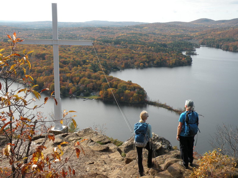
Scramble down a few feet for an outstanding view over Megunticook Lake to Ragged Mountain and the ski slopes of Camden Snow Bowl as well as Bald Mountain just next door. Here also is the famous cross and a granite marker dedicated to Elenora French, who fell to her death near this spot in 1864 trying to catch her windblown hat.
Next, strike off southeast on Scenic Trail and follow an undulating route over several knobs with extensive open ledges and more bucolic views of the surrounding hills and farmlands and eastward to the ocean. The dark forests capping the heights of Megunticook are now visible ahead.
Join the Ridge Trail and cross a couple of brooks before trending gradually upward past several outlooks, including one at the far end of Barrett’s Cove Cliff, a popular climber’s crag. On a sometimes rough trail of roots and rocks amid the hemlocks, spruce and pines, pass Jack Williams Trail. Soon, pass Zeke’s Trail. A level stretch ahead leads to a nice lunch ledge and a fine window to Mt. Battie and its winding auto road, and to the homes and farms in the Megunticook River Valley.
Traverse a narrow ledge and pass several cairns to arrive at the wooded summit of Mount Megunticook, marked by a big rock pile. At 1,385 feet, the peak is the highest mainland mountain on the U.S. Atlantic coast. Just beyond, pass Slope Trail and continue easily over bog bridges and through spruce woods along the ridgeline before dropping slightly to Ocean Lookout, a huge system of ledges and cliffs and a popular spot that rivals Maiden Cliff for views.
Camden village and its harbor are in focus below, and offshore are the islands of Vinalhaven and North Haven. Farther out is Deer Isle, and Isle au Haut, part of Acadia National Park. On a clear day you can see all the way to Casco Bay 60 miles south.
From the lookout, descend steeply via Tablelands Trail and follow this beyond a number of trail junctions. After a long mostly level section, the path crosses the Mt. Battie Auto Road and climbs easily another half-mile to the summit parking lot and just beyond, the stone observation tower and World War I Memorial on top.
Take the Carriage Road and Carriage trails to return to Route 52, 1.5 miles south of the starting point.
Note: Hunting is allowed in the southern section of Camden Hills State Park, which includes the second half of this hike. For more information and a trail map, go to www.parksandlands.com.
Carey Kish of Bowdoin is writing a book on classic Maine coast hikes from Kittery to Eastport. Send comments and suggestions to: MaineOutdoors@aol.com.
Send questions/comments to the editors.

Success. Please wait for the page to reload. If the page does not reload within 5 seconds, please refresh the page.
Enter your email and password to access comments.
Hi, to comment on stories you must . This profile is in addition to your subscription and website login.
Already have a commenting profile? .
Invalid username/password.
Please check your email to confirm and complete your registration.
Only subscribers are eligible to post comments. Please subscribe or login first for digital access. Here’s why.
Use the form below to reset your password. When you've submitted your account email, we will send an email with a reset code.