

The Department of Inland Fisheries and Wildlife will remove several wooden planks from a Scarborough dam in an effort to alleviate chronic flooding problems upstream in Old Orchard Beach.
This action comes on the heels of a meeting that was held in Old Orchard Beach Jan. 8, addressing the problem of flooding in the Walnut Street and Milliken Street neighborhoods of northeast Old Orchard Beach.
At the meeting, engineering company Milone & MacBroom presented its findings, and posed possible alternatives to alleviate the flooding.
According to Old Orchard Beach residents in the four condominium complexes on the northeast end of town, including the Davenport Condominium complex and Tidewater Lofts, the flooding has become so severe that it has cost them thousands of dollars in damages.
“We are flooded time after time, and I believe the dam in Scarborough is impeding the flow of water,” Tidewater Lofts resident Jack Sarno said at the meeting earlier this month.
The hope for the project is that removing the planks would allow the freshwater wetland located upstream from the dam (on the Old Orchard Beach side) to more fully drain out, thus lowering water levels upstream.
Scott Lindsay, regional wildlife biologist with the Department of Inland Fisheries and Wildlife, will oversee the removal of the boards from the dam in the upcoming weeks.
“The plan following the meeting was to modify the existing structure to see if it lowers water elevations upstream,” Lindsay said. “We have an engineer who will be coming in to set up a benchmark to measure water elevations as we remove planks from the dam.”
Although the dam itself is aluminum, there are wooden planks that reinforce and hold in water at various points along the dam. The planks “provide an opportunity to adjust the dam structure,” according to Lindsay, and by removing several planks, Lindsay and his team are hoping the water elevation will lower by an estimated 10 inches to a foot.
The Scarborough dam sits on 3,100-plus acres of wetlands located behind Pine Point Beach and Prouts Neck. The wetland area is owned by the state and managed by the Department of Inland Fisheries and Wildlife.
“The primary goal of the dam was to retain fresh water upstream,” said Lindsay. “Fresh water adjacent to salt water provides significant diversity and high wildlife habitat value.”
The dam area takes up approximately 450 acres and is located on Jones Creek, near Cascade Brook and Blue Point Road. The dam is located a half-mile upstream from the ocean, and downstream from a large freshwater wetland area that is 1.25 miles east of Walnut Street in Old Orchard Beach. The dam is approximately 5 feet high, 15 feet wide, and 10 feet long.
“This is an area that has been modified by people since before the 1900s, when the development of the Eastern Division Railroad blocked that natural outlet to the ocean,” Lindsay said. “Our primary concern is that it is a wetland area and also a nesting habitat for many water fowl species. So we’re manipulating the dam outside of nesting season, which is April through June.”
Lindsay warned that the flooding problem may be more complex. Another possible outcome would be that by removing the boards, the overall tidal flow that comes in to the dam from the ocean could become more drastic, thus potentially increasing overall water levels.
“Removing the boards may not result in a rapid response,” Lindsay said.
Another problem Lindsay cited was the culverts, or openings under a road or causeway, that exist beneath the railroad tracks that cross the wetland area.
“The size of the culverts aren’t big enough to handle water from rain upstream,” Lindsay said. “So the water never leaves or gets flushed out of the area.”
After the state engineer removes the planks, Lindsay and his team will assess water elevations weekly, and then submit a written elevation chart with observations and photos of the area to the Old Orchard Beach public works department.
“In my view, this is a problem that is more complicated than just the dam, but if the dam is a contributing factor, then we’ll do our part to assist,” Lindsay said.
If removing the planks doesn’t solve the issue, the U.S. Army Corps of Engineers and Environmental Protection Agency, along with the Department of Marine Resources, may need to get involved.
The organization Friends of Scarborough Marsh also has a vested interest in the area. According to the group’s president, C.D. Armstrong, their purpose is to “preserve, protect and conserve the marsh and Scarborough’s watershed.” The marsh contains one of the largest productive wildlife habitats and ecosystems in the region, and also serves to protect the inland region around it from storm damage along the coastline.
Another concerned organization is Ducks Unlimited, which helps to protect and conserve waterfowl habitats. Ducks Unlimited collaborated with the town of Scarborough in 1998 for its first project in New England, to help preserve the Scarborough Marsh waterfowl habitat. Craig Ferris, regional biologist with Ducks Unlimited, has been following the dam project closely.
One alternative posed by Malone & McBroom was to remove the dam altogether.
“Although that was the cheapest proposed option at about $50,000, removing the dam altogether may alleviate flooding temporarily, but it won’t help during storms,” Ferris said.
According to the report, Malone & McBroom dismissed the option of pumping out water because that was not considered a viable solution.
“If they remove the dam, the value of the marsh would be considerably compromised and the habitat for nesting birds would be considerably diminished,” Ferris said. “There is no obvious solution here.”
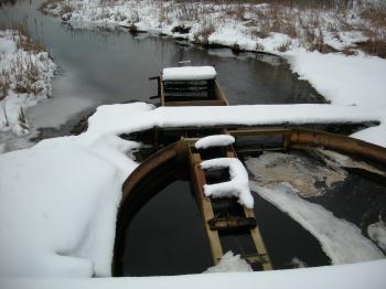 Scarb dam- The steel dam is shown in winter, looking upstream.
Send questions/comments to the editors.

Success. Please wait for the page to reload. If the page does not reload within 5 seconds, please refresh the page.
Enter your email and password to access comments.
Hi, to comment on stories you must . This profile is in addition to your subscription and website login.
Already have a commenting profile? .
Invalid username/password.
Please check your email to confirm and complete your registration.
Only subscribers are eligible to post comments. Please subscribe or login first for digital access. Here’s why.
Use the form below to reset your password. When you've submitted your account email, we will send an email with a reset code.