

Maine has plenty of great places to bike. You can ride along the water (fresh or salt), hit the hills to the west (rolling or just plain steep), pedal alongside the traffic in cities and towns, or alongside tractors and cows through the farmlands.
My problem is that despite all the great rides I can go on, I tend to stick to the ones I know.
Additional Photos
I head down Route 88 through Falmouth because I know there are plenty of impressive homes to look at. I circle around routes 25, 202 and 22 through Gorham, Buxton and Westbrook because I know the hills are minimal. I ride through Cumberland and Yarmouth because I know the roads are in pretty good shape and there’s no construction going on.
But sometimes the same old rides get a little boring.
Actually, they get a lot boring.
Thankfully, a friend recently turned me on to MapMyRide.com, where, in addition to creating your own rides complete with distance and elevation, you can see — and try — rides that other Mainers and program users are pedaling away on.
Go to the website, create a user name and password, and then plug in the name of a town where you’d like to ride.
Try South Portland, and 260 options in Portland, SoPo and Cape Elizabeth immediately become available. Included in this area are the 14.68-mile Tri for the Cure course, some of the weekly routes ridden by Portland Velo Club, the Lighthouse Century ride and a 59.64-mile trek from Cape Elizabeth out to Buxton and back.
There’s a ride for every level at any distance.
Routes, complete with their distances, are named by the people who created them. Click on the icon for an individual ride and also get the start, max and gained elevation, turn by turn directions, nearby similar routes and sometimes a route description. With the right plug-in you can even get a 3-D course fly-by video.
With MapMyRide.com, if you’re heading to a town — or even state — you’re not familiar with, you can feel comfortable bringing your bike and hitting the road.
I took my bike up to Augusta on a Saturday and tried part of the 35.79-mile Augusta-to-Richmond Swing Bridge ride. The creator of this route was absolutely correct, parts of Route 24 are pretty rough.
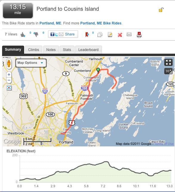
And for the sake of sharing, I mapped one of my favorite routes from Portland’s Back Cove out to Cousins Island in Yarmouth. It’s 26.30 miles if you do it out and back. Go ahead and give it a try.
AN APP FOR THAT
Bikers who want one gadget and one gadget only can ditch their bike computer and download Abvio LLC’s Cyclemeter GPS app to their iPhone.
Friends of mine used the app on a recent ride and it has everything a wireless bike computer has and more. It also gives info larger and in color.
Just carry your phone in your pocket or seat bag while on your ride, then check your ride time, distance, top speed, average speed and calories burned. If you check mid-ride, you’ll also see the remaining distance if you’re on a mapped ride.
The app also keeps a list of all your routes, offers color maps, speed and elevation graphs and a calendar to help with training. Check it out at cyclemeter.com.
Deputy Features Editor Karen Beaudoin can be reached at 791-6296 or at:
kbeaudoin@pressherald.com
Send questions/comments to the editors.

Success. Please wait for the page to reload. If the page does not reload within 5 seconds, please refresh the page.
Enter your email and password to access comments.
Hi, to comment on stories you must . This profile is in addition to your subscription and website login.
Already have a commenting profile? .
Invalid username/password.
Please check your email to confirm and complete your registration.
Only subscribers are eligible to post comments. Please subscribe or login first for digital access. Here’s why.
Use the form below to reset your password. When you've submitted your account email, we will send an email with a reset code.