

Twenty-five years ago today — April 1, 1987 — the Kennebec River erupted from its banks, ripping out bridges and roads, destroying homes and wrecking businesses in the worst flood in Maine history.
Experts called it a 500-year flood for the state’s major rivers, including the Sebasticook River in Pittsfield and Winslow and the Sandy River in the Farmington area.
Additional Photos

Everyone else called it the April Fools’ Day flood.
By the time it was over, 2,100 homes had been flooded; 215 were destroyed and 240 more suffered major damage, according to the Maine Emergency Management Agency.
Hallowell resident Sam Webber was a teacher at Hall-Dale High School at the time. He recruited several students to rescue display cases from a store on Water Street in Hallowell called the Starting Block.
“The water was rising fast and about halfway up the wheels of my pickup truck,” Webber said. “After we managed to move the display cases to my garage, we returned to help transfer items from Boynton’s Market to an AG trailer. The students wanted me to bring my canoe downtown. I did, but felt it was too dangerous to have any of them go with me.”
Webber saw a man launching an inflatable raft on Water Street and, fearing for his safety, encouraged him to come into the canoe with him. They paddled north on Water Street from Boynton’s and got caught in the torrent coming down the street and flowing out lower Central Street back into the river.
“We were barely able to paddle forward and grab hold of a light pole by the store then known as Paper Kicks. From there we made our way back to dry land near Boynton’s. When my wife found out about this, she made me promise to never try this stunt again,” Webber said.
In Skowhegan, Sentinel reporter Darla Pickett and others were cut off for days after one of the twin Margaret Chase Smith bridges washed out. Bridges also were out in Norridgewock and on U.S. Route 2 east of town, turning Skowhegan into an island.
But it was the destruction of the former railway bridge, by then a foot bridge, connecting downtown Skowhegan with the residential south side of town, that was the most dramatic, she said.
Pickett said she began taking photographs of the river as it rose into the parking lot of the former Solon Manufacturing building on Island Avenue and lapped the roadway bridges before overflowing them.
She said she went up onto the roof and jumped the span to the next building to shoot pictures.
“It gives me the chills to just think of it,” she said. And after making the effort, “I couldn’t get my film out of town.”
Maine had a normal snowpack and a normal flood potential in late March 1987, the Maine Emergency Management Agency later wrote in an analysis of the flood. But two storms brought rain to the mountains and foothills of Maine and New Hampshire, which combined with 6 or more inches of melted snow. The water ran over frozen ground, and streams and rivers began to rise.
By April 2 in Augusta, the Kennebec had crested 20 feet above flood stage. Fourteen of Maine’s 16 counties were declared federal disaster areas.
In Waterville, Jeff Karter, owner of Waterville Florist, then on Water Street, remembers that day well.
“The National Guard allowed us to go back into the building to get out what we wanted,” Karter said. “After that, they would not let us back in, because the river was rising an inch every couple of minutes. They needed to evacuate everybody out of the building. We lost everything. We had just renovated that August; then April 1st — all gone.”
Augusta Fuel Co. employee Marc LaCasse — now the company owner — watched in amazement as what seemed like typical spring flooding turned into something much more destructive.
The company offices are off Bond Brook, about 100 feet away; and at the height of the flood, the water was flowing from both the brook and the Kennebec River.
“At some point mid-morning, that was when we had issues with our fuel distribution plant — it fell over,” LaCasse said. “I was standing there watching it happen. So, that’s the one thing that pops into my memory right off the bat, was those four 30-foot-high, 25,000-gallon fuel oil tanks popping up off their bases and slowly falling over. I was almost in disbelief initially and a little bit of panic. At that point, we realized this was not our typical spring flooding issue.”
Seven houses on Winslow’s Lithgow Street were swept into the Kennebec River, as was the Winslow Historical Museum and the nearby Fort Halifax blockhouse, built in 1754, which had survived the French and Indian War and dozens of smaller floods, but not the flood of ’87.
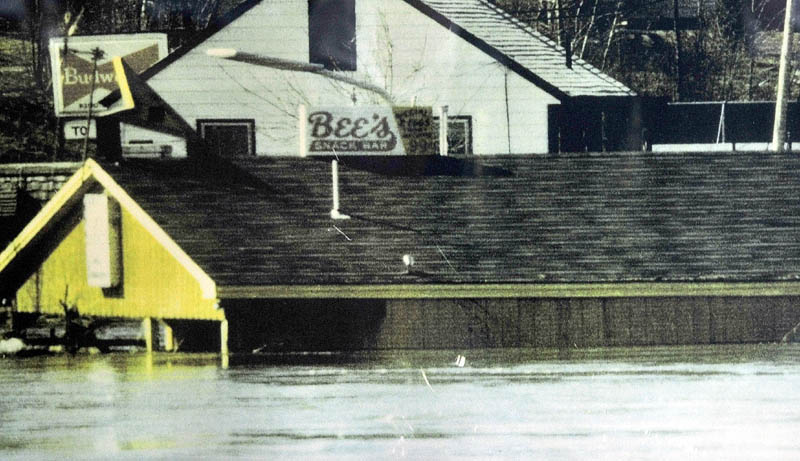
Evelyn Willette and her late husband, Roland, owned and operated Bee’s Snack Bar, a restaurant at the end of Lithgow Street, on the riverbank. Their home also was on Lithgow Street.
The couple and their children became unemployed and homeless in a double whammy of the Sebasticook and Kennebec rivers roaring over their banks. Both buildings survived — in spite of the fact that floodwater rose to the eaves of the restaurant roof.
She said her husband had had the foresight to shore up the restaurant with reinforcing steel beams and a new foundation along the riverside months earlier. Otherwise, the snack bar would have washed away.
“It was just sitting on the river bank,” she said. “It was just a shack when we bought it — it would have gone.”
Doug Harlow — 612-2367
dharlow@centralmaine.com
Send questions/comments to the editors.

Success. Please wait for the page to reload. If the page does not reload within 5 seconds, please refresh the page.
Enter your email and password to access comments.
Hi, to comment on stories you must . This profile is in addition to your subscription and website login.
Already have a commenting profile? .
Invalid username/password.
Please check your email to confirm and complete your registration.
Only subscribers are eligible to post comments. Please subscribe or login first for digital access. Here’s why.
Use the form below to reset your password. When you've submitted your account email, we will send an email with a reset code.