

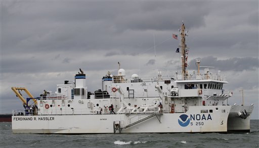
NORFOLK, Va. — A federal research vessel that will help update nautical charts on the East Coast will be commissioned Friday, doubling the size of the Atlantic mapping fleet and finally providing a replacement for the ship that helped find John F. Kennedy Jr.’s plane wreckage near Massachusetts.
The National Oceanic and Atmospheric Administration ship Ferdinand R. Hassler will be home ported in New Castle, N.H., next spring. It is the numerical replacement for the Rude, which was decommissioned in 2008 after a 41-year-career where it found an ancient cannon in a Virginia river as well as wreckage from Kennedy’s plane in 1999 and TWA flight 800 in July 1996.
Additional Photos

The new ship is faster, has a longer range and can stay out to sea more than three times longer than its predecessor.
“This ship is vastly superior to Rude in almost every way in terms of capability, endurance. So it’s not quite fair to call this a replacement of Rude,” said Lt. Cmdr. Benjamin Evans, the Hassler’s commanding officer.
NOAA will use the $22 million vessel to map a frequently changing, turbulent sea floor that can become littered with sunken ships and cargo that alters the depths required for safe passage. That’s particularly important for entranceways to the nation’s ports as ships get larger and require deeper drafts.
“We are literally having ships that are timing, in some cases, when they come in and out of port based on the stage of the tide,” said Lt. Cmdr. Chris van Westendorp, the Hassler’s executive officer.
Shortly after the Hassler was delivered to NOAA last year, it was called into service early following Hurricane Irene. Over two days, it was responsible for determining whether the shipping lanes leading into the Port of Virginia and the Chesapeake Bay were altered.
“Then and only then did the coast guard reopen the port, so this is a big deal for folks. The Coast Guard doesn’t want to take any risks. The shippers don’t want to take any risks, particularly for the very deep-draft vessels,” Evans said. “Every inch that you load those ships deeper in the water is pure profit.”
Each hour the Virginia port was closed by the Coast Guard, it cost about $5 million in lost revenue.
The 124-foot ship will conduct hydrographic surveys of the sea floor using side scan and multibeam sonar. The ship was designed with a twin-hull that will give it a more stable operating platform that will reduce errors that can occur due to ship movements in rough seas.
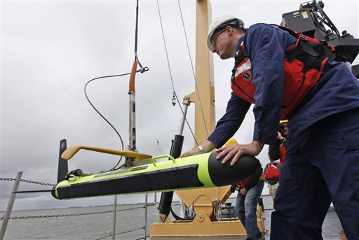
It is also equipped to deploy buoys and unmanned submersibles for general oceanographic research.
NOAA typically has two coastal mapping vessels on the West Coast and two on the East Coast, but has been down one on the East Coast ever since the Rude’s decommissioning. While the Hassler could be called in to map the sea bottom from the Great Lakes to the Caribbean Sea, it is expected to primarily operate in the Northeast. A second mapping ship is already home ported at NOAA’s Marine Operations Center in Norfolk.
“It’s fundamentally different in the Northeast than here in that there’s still a lot of area in Maine and the rocky coast of the Northeast that hasn’t been properly surveyed in 50, 60, maybe 100 years,” Evans said aboard the ship Tuesday as it tested new sonar equipment near the mouth of the Chesapeake Bay. “So up there we’ll be bringing the modern full-bottom coverages survey techniques to areas which have really never been properly surveyed.”
One of the reasons New Hampshire was chosen as the Hassler’s home port instead of Norfolk, where the Rude was based, is because NOAA has a partnership with the University of New Hampshire. The university says the Center for Coastal and Ocean Mapping/Joint Hydrographic Center was created in 1999 to develop tools to advance ocean mapping and hydrography.
Evans said having the university nearby will improve coordination between operations and research.
The ship was named the Hassler by a team of tenth-grade students and a teacher from Naugatuck High School in Naugatuck, Conn., who won a NOAA naming contest. The ship’s namesake served as the first superintendent of the U.S. Coast Survey, a precursors to the NOAA Office of Coast Survey.
___
Send questions/comments to the editors.

Success. Please wait for the page to reload. If the page does not reload within 5 seconds, please refresh the page.
Enter your email and password to access comments.
Hi, to comment on stories you must . This profile is in addition to your subscription and website login.
Already have a commenting profile? .
Invalid username/password.
Please check your email to confirm and complete your registration.
Only subscribers are eligible to post comments. Please subscribe or login first for digital access. Here’s why.
Use the form below to reset your password. When you've submitted your account email, we will send an email with a reset code.