

YARMOUTH – There was a time, before the late 1950s, when Yarmouth was connected to its coastal waterfront, where boats were built and people lived and commerce thrived.
Then Interstate 295 was built, bisecting the lower village and severing the harbor from the town.
Additional Photos

Now, town officials and consulting engineers are working on a long-range plan to reconnect the town to its waterfront with a variety of pedestrian-oriented improvements.
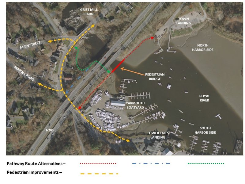
Some changes would be simple, such as adding sidewalks and street parking along Lafayette Street (Route 88) in the lower village. Other proposed improvements are more imaginative, such as building a shoreline pathway beneath I-295 and a footbridge across the Royal River to Yarmouth Town Landing.
“This is our redemption effort to reconnect to the waterfront,” said Town Planner Vanessa Farr. “This area has been an economic engine for the town. We’ve become disconnected from our history. There’s potential for this plan to revitalize the area and make it a destination.”
Farr got a $29,000 Maine Coastal Program grant for a feasibility study that would be the basis of the waterfront access plan. Baker Design Consultants of Yarmouth is doing the work, with support from a variety of local and state agencies.
Residents have long talked about reconnecting to a working waterfront that employs 343 people and generates $25 million a year in commercial revenue, Farr said.
Most recently, the Royal River Corridor Master Plan noted the recreational and economic development opportunities that would come with improved links to the waterfront area, which is fed by Lafayette Street and Main Street (Route 115).
No cost estimates have been attached to the fledgling waterfront access plan, though construction of shoreline pathways to the town’s marinas and a three-span footbridge — both in tidal zones — could cost millions of dollars. The feasibility study will be presented at a public forum later this year.
The Town Council has yet to see or endorse the waterfront access idea, but it could produce development guidelines that would influence road improvements and other construction in the lower village and waterfront area for years to come.
“There’s no harm in thinking big,” said Town Manager Nat Tupper. “But we should be prepared for incremental steps.”
Improvements in the lower village would include the addition of sidewalks, street parking, street trees and other measures meant to slow traffic and ensure pedestrians’ safety.
Waterfront improvements would include a shoreline pathway starting at Lafayette Street, on the south side of the Royal River bridge, and extending to the marinas and the town landing, which aren’t easily walkable destinations now.
Few residents have heard about the waterfront access plan because it’s still in the works.
While some residents and business owners in the lower village say they would welcome the improvements, others question the potential cost and logistics.
“I think it’s a great idea,” said Lisa Weickert, who owns the Celadon salon at Lafayette Street and Marina Road.
“I think the improvements will draw foot traffic here and improve access to the water,” Weickert said. “It would be great if they could slow down vehicle traffic, because people go by here so fast. They just roll through the stop sign all the time.”
Erik Anthony, whose house on Lafayette Street is for sale and whose property extends to the riverbank, said he would be “supportive of anything that protects open space and promotes public access.”
Stephen Welch, a former zoning board member who has operated Reed’s Machine Shop on Lafayette Street since 1973, said he’s waiting to see a more detailed plan.
“I’m skeptical, but then I question everything until they prove it’s going to work,” Welch said. “This isn’t the first time they’ve tried to address traffic and pedestrian problems. I don’t know how they’re going to slow down this traffic.”
William Honan owns Bay Properties Realty, across Lafayette Street. He said he would welcome pedestrian improvements along Route 88, where traffic whizzes by, but he questioned the shoreline pathways and footbridge.
“That just seems too complicated, too costly and too difficult to get permits,” Honan said. Farr, the town planner, said the waterfront work would require permits from various state and federal agencies, but its status as a water-oriented commercial zone likely would make it easier for the town to get necessary approvals.
“There’s a lot of potential here waiting to be tapped,” Farr said. “This will be a gathering place.”
Staff Writer Kelley Bouchard can be contacted at 791-6328 or at:
kbouchard@pressherald.com
Send questions/comments to the editors.

Success. Please wait for the page to reload. If the page does not reload within 5 seconds, please refresh the page.
Enter your email and password to access comments.
Hi, to comment on stories you must . This profile is in addition to your subscription and website login.
Already have a commenting profile? .
Invalid username/password.
Please check your email to confirm and complete your registration.
Only subscribers are eligible to post comments. Please subscribe or login first for digital access. Here’s why.
Use the form below to reset your password. When you've submitted your account email, we will send an email with a reset code.