


A group of University of Southern Maine students is installing an interactive art exhibit along Portland’s Bayside and Eastern Promenade trails aimed at helping users visualize the potential impact of sea-level rise tied to climate change.
Students used GPS technology and “inundation maps” to create a walking tour of the Portland peninsula’s waterfront and parts of downtown if sea levels rise 3 feet by the year 2100, as some international reports suggest. The “King Tides Trail” largely follows the Bayside and Eastern Prom trails but will feature stations at locations that the project’s creators say will help users observe the tides as they are today and envision what they could look like in the future.
Additional Images
“The purpose is to increase public awareness of sea-level change and to make visible something that seems incremental,” said Jan Piribeck, a USM art professor overseeing the project as part of her class “Shaping the Terrain: Sea Level Change in Casco Bay.”
“People don’t pay as much attention to sea-level rise because they don’t see it,” Piribeck said. “Part of what we are doing here is using art to help them see something.”
The installations are also part of the Gulf of Maine King Tides Project, which organized an October photo contest in which residents from throughout the Gulf of Maine region – Maine, New Hampshire, Massachusetts, New Brunswick and Nova Scotia – submitted photos of the impacts of one of the highest tides of the year, also known as the “king tide.” Although natural events, “king tides” can offer a sneak peak at the future effects of sea level rise, organizers said.
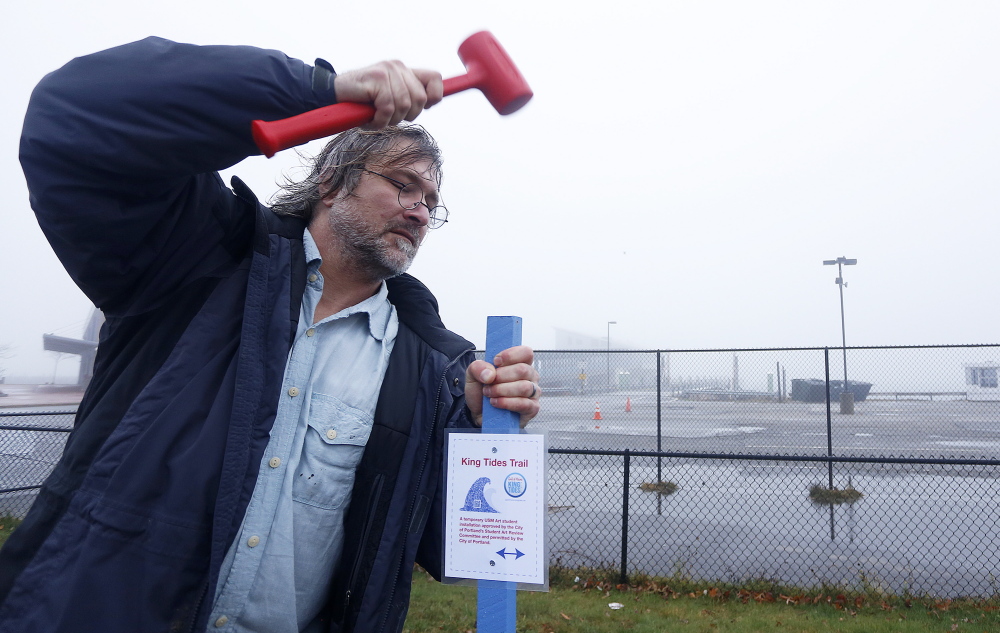
On Monday, Piribeck and a group of students and other workers hammered more than two dozen blue stakes topped with solar-powered beacons into the soil at key locations along the trail. Those locations include an overlook of the B&M Baked Beans facility, already flood-prone areas of Bayside, and East End Beach, where a 3-foot sea rise would come up to the chain-link fence separating the trail from the beach area.
Each stake holds a small “King Tides Trail” placard with a “QR Barcode” that users can scan using a smartphone to pull up the location on a Google map. Although not yet fully functional, that map will eventually feature a red line showing the projected inundation line on the Portland peninsula if seas rose 3 feet. Piribeck said she hopes the map will be fully operational by the trail’s official “opening” Dec. 8.
Although the political debate over climate change continues, particularly in the U.S., the Intergovernmental Panel on Climate Change wrote earlier this month that it is “extremely likely that more than half of the observed increase in global average surface temperature from 1951 to 2010 was caused by the (man-made) increase in greenhouse gas concentrations” and other human-caused factors. Those temperature increases have “very likely” made a substantial contribution to rising sea levels.
The climate change panel, a United Nations-chartered group that brings together scientists from around the world, predicted in October 2013 that without aggressive reductions in climate-warming greenhouse gases, global sea levels could rise between 1 and 3 feet by the year 2100. The map compiled by Piribeck’s class shows sea-level rise based on the highest tide level for all of 2014.
The “King Tides Trail” exhibit is expected to last through Jan. 23.
USM students and project organizers will hold a “public trail opening” on Dec. 8 at noon at the end of the Bayside Trail near Somerset and Elm streets. The rain date for the event is Dec. 12 at 4 p.m.
Send questions/comments to the editors.

Success. Please wait for the page to reload. If the page does not reload within 5 seconds, please refresh the page.
Enter your email and password to access comments.
Hi, to comment on stories you must . This profile is in addition to your subscription and website login.
Already have a commenting profile? .
Invalid username/password.
Please check your email to confirm and complete your registration.
Only subscribers are eligible to post comments. Please subscribe or login first for digital access. Here’s why.
Use the form below to reset your password. When you've submitted your account email, we will send an email with a reset code.