


With another storm and a new dose of frigid weather bearing down on southern Maine, the shortest month of the year is starting to feel like the longest.
The average daily temperature through Tuesday has been 11.9 degrees, giving this month a shot at becoming the coldest February on record, according to National Weather Service data.
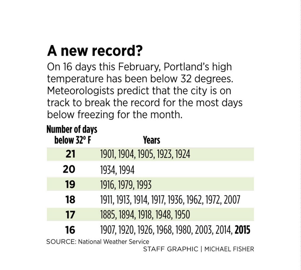
In another indication of the recent unrelenting cold, the high temperature never made it to the freezing point, 32 degrees, on 16 of the first 18 days of February, as measured at the Portland jetport. And the long-range forecast suggests that with 10 days to go, this month could break the record of 21 February days in which the temperature didn’t reach freezing. That happened in five different years, most recently in 1924.
The coldest February on record was in 1934, when 20 days didn’t reach freezing and the average daily temperature was 13.9 degrees, according to the weather service.
The numbing temperatures have been accompanied by unusually high snowfall totals, with 79.6 inches recorded at the jetport before the storm that was supposed to start late Wednesday.
That means communities – like homeowners – are struggling to find somewhere to put it all.
“Usually you would have some days of melting,” said meteorologist David Epstein, who writes The Maine Forecast blog for pressherald.com. Most of the snow from recent storms is still here because those same cold temperatures have kept it from melting, he said.
“I’m a weather guy, so it’s intriguing. I’m also a homeowner, so I don’t like it,” said Epstein, who has been up on his roof twice so far to clear snow.
For the new storm, the weather service office in Gray is forecasting 6 to 10 inches of snow along the coast and inland as far as Rangeley. Winds are expected to be 5 to 10 mph, with 20 mph gusts and temperatures in the low 20s. After a lull during the day Thursday, the storm is likely to resume later in the day and last through early Friday, the weather service said.
Frigid air is expected to move in Friday night, with subzero cold predicted, followed by highs in the teens Saturday.
FINDING NEW PLACES TO DUMP SNOW
Portland, with its web of narrow, busy streets, is developing contingency plans as the snow continues to pile up.
Not including Thursday’s snowfall, Portland has received about 80 inches of snow this winter, nearly twice the amount that normally falls by Feb. 18. The city already has issued 18 parking bans to clear the snow, including the bans that target the yellow zones downtown.
Public services crews have been dumping snow from the peninsula in the area between the inbound and outbound lanes of Franklin Street, as well as on a growing snow mountain off Somerset Street.
The city’s primary dump site is out past the jetport, but that pile is nearing an FAA-mandated height limit.
“Like any obstruction, the snow is just like a tree that grows too high,” said Paul Bradbury, jetport manager. The FAA limits obstructions near a primary landing and take-off area to 56 feet high, but the city keeps the snow pile at 40 feet or below so it can operate large machinery on it without worrying about exceeding the limit, Bradbury said.
“They try to make a nice plateau and fill the entire site to that level,” he said.
The limits there meant the city had to find new places for snow. It has started using a city site on Riverside Street, and the University of New England has given the city permission to use one of its lots off Bishop Street. The lots have yet to be used, but probably will be over the next few days, said city spokeswoman Jessica Grondin.
The city hasn’t had to seek additional snow dump sites for at least the past five years, she said.
“This is very unusual to get this much snow in this short a time period,” Grondin said. “Normally we would have melting in between storms.”
Because of the large amount of snow, the city said it will not begin enforcing the requirement that residents clear their sidewalks until Monday.
STUCK IN ACTIVE WEATHER PATTERN
The early winter had its ups and downs when it comes to temperature and snow accumulation.
November had a cold spell, including snow on the ground for Thanksgiving. December was a fairly warm month that left green grass exposed near the end of the month, before snow moved in again.
There was a blizzard in late January. And five snowstorms have hit the state in February, dropping more than 2 feet in total at the jetport.
“We’ve been in a constant trough here in the East,” said James Brown at the weather service in Gray. The trough has produced low temperatures and active weather patterns in Maine and a warm spell in a ridge in the middle of the country, Brown said.
“That’s the way it sets up. Somebody is in that trough and somebody is in that ridge all the time,” he said.
The trough shows no sign of leaving, but the area will get a reprieve of sorts. Temperatures could be in the 30s by Sunday.
“We may get some mixed precipitation out of that instead of all the snow,” Brown said. “It would be the first time that’s happened in a while.”
Send questions/comments to the editors.

Success. Please wait for the page to reload. If the page does not reload within 5 seconds, please refresh the page.
Enter your email and password to access comments.
Hi, to comment on stories you must . This profile is in addition to your subscription and website login.
Already have a commenting profile? .
Invalid username/password.
Please check your email to confirm and complete your registration.
Only subscribers are eligible to post comments. Please subscribe or login first for digital access. Here’s why.
Use the form below to reset your password. When you've submitted your account email, we will send an email with a reset code.