


The last time forecasters observed an El Nino event like this year’s, Maine froze under a sheet of ice a few months later and stayed that way for more than two weeks.
But that extreme 1997-98 weather pattern doesn’t necessarily serve as a predictor of what could happen this winter.
“Over the years, we haven’t been able to draw any firm conclusions about how El Nino events affect weather in the Northeast because there are so many factors that come into play,” said Nikki Becker, a meteorologist with the National Weather Service in Gray. “There likely will be some impact, but what that impact is depends on a lot of things and it’s really too early to tell.”
El Nino is the name given to a climatological event, usually in December, that is marked by shifting winds contributing to unusually warm water in the east-central equatorial Pacific Ocean. The phenomenon was first observed by fishermen off the coast of Peru in the 19th century.
These events typically occur every few years, but sometimes the impacts are more pronounced.
According to the weather service, “The presence of El Nino can significantly influence weather patterns, ocean conditions, and marine fisheries across large portions of the globe for an extended period of time.”
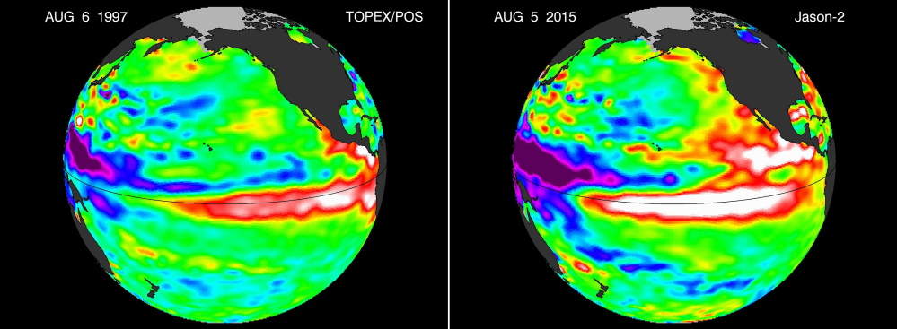
Climatologists are predicting that this year’s El Nino, which already has been compared to Godzilla and dubbed Bruce Lee after the late martial arts legend, could rival the record event that affected much of the U.S. 18 years ago and similar major events in 1982-83 and 1972-73.
The El Nino of 1997-98 worked its way into popular consciousness through constant news coverage of its broad impacts, such as unrelenting rain in California, which produced a series of major mudslides.
Western states, particularly California, are hoping the current El Nino pattern will again lead to heavy rainfall and counteract a prolonged drought.
But there is no guarantee there, either.
“A big El Nino guarantees nothing,” Mike Halpert, deputy director of the National Oceanic and Atmospheric Administration’s Climate Prediction Center, told the Associated Press. “At this point there’s no cause for rejoicing that El Nino is here to save the day.”
Historically, El Nino does bring heavy rain, starting on the West Coast and traveling east. Often, temperatures are warmer in the northern half of the country, but not significantly so.
El Nino events also usually temper the Atlantic hurricane season, leading to less powerful storms, while creating more powerful cyclone-type storms in the Pacific.
The major 1997-98 El Nino resulted in warmer temperatures in the Northeast, including Maine, and less snow, but the downside was freezing rain and ice, which contributed to one of the biggest natural disasters in the state’s history.
Still, Becker said Maine could just as easily see a snow-filled winter.
“The precipitation, if there is an increase, could be snow, or freezing rain, or just rain,” she said.
The National Weather Service often only makes projections three months in advance, Becker said.
The most recent long-term projections, for the months of August, September and October, suggest that temperatures will be above normal and precipitation will be below normal. Normal, Becker said, is defined as a 30-year average.
Send questions/comments to the editors.

Success. Please wait for the page to reload. If the page does not reload within 5 seconds, please refresh the page.
Enter your email and password to access comments.
Hi, to comment on stories you must . This profile is in addition to your subscription and website login.
Already have a commenting profile? .
Invalid username/password.
Please check your email to confirm and complete your registration.
Only subscribers are eligible to post comments. Please subscribe or login first for digital access. Here’s why.
Use the form below to reset your password. When you've submitted your account email, we will send an email with a reset code.