


Winter’s first significant snowstorm is going to be pretty much unavoidable, forecasters at the National Weather Service in Gray predicted Sunday evening.
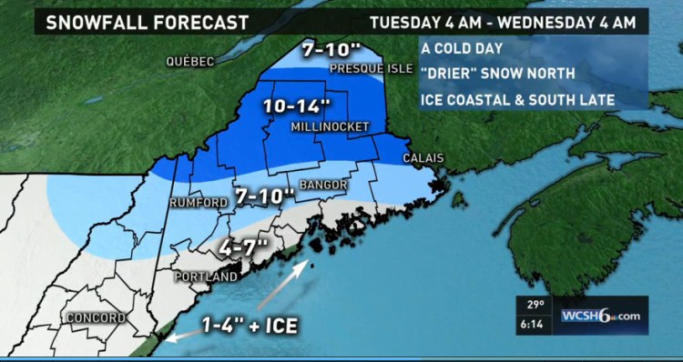
Most of Maine will see snow, with 6 or more inches in the forecast for Portland and surrounding areas on Tuesday. Central and northern parts of the state could get anywhere from 7 to 14 inches of snow by the time the storm ends Tuesday night.
Portland’s first major storm of the season will strike early Tuesday morning and could throw a monkey wrench into the morning commute.
Chris Kimble, a meteorologist at the National Weather Service, said the snow should start around 5 a.m. and continue throughout the day. The snow has the potential to mix with sleet or ice, creating treacherous driving conditions.
Forecasters are pretty confident this storm won’t miss the state.
The weather service issued a winter storm watch on Sunday, meaning there is a greater than 50 percent chance of snow and a potential for significant snow, sleet or ice accumulation. The winter storm watch, which goes into effect late Monday night, will remain in effect through Tuesday night.
Kimble said Tuesday’s storm will almost certainly make Portland’s weather record books.
“We haven’t had any measurable snowfall this year,” Kimble said.
The latest date of the first measurable snowfall in Portland is Jan. 16, 2000. The second latest date of first measurable snow is Dec. 24, 1912, which means that if the storm proceeds on course as predicted, Dec. 29, 2015, will surpass the century-old mark for second latest date. Measurable snow is defined as any amount over 0.1 inch.
Kimble said snowfall on Tuesday could be heavy at times, but winds won’t be strong, which means the storm will not have enough power to produce blizzard conditions.
While southern Maine braces for its first winter storm, the central and northern parts of the state were forced to deal with a snowstorm that began Sunday morning.
The National Weather Service’s Caribou office reported that Frenchville at the northernmost tip of Aroostook County received 9 inches of snow on Sunday. Madawaska got 8.5 inches; Fort Kent, 8 inches; Presque Isle, 6 inches; and Houlton, 5.8 inches.
Snow also fell in Hancock, Penobscot, Piscataquis, Somerset and Washington counties with the town of Greenville receiving 7 inches; Millinocket, 7.5 inches; Bangor, 2 inches; and Princeton in Washington County, 4 inches.
Temperatures are expected to drop on Monday, setting up conditions for Tuesday’s storm, the National Weather Service said.
The low in Portland on Monday morning will reach 26 degrees, with lows of 11 degrees in Rangeley, 8 degrees in Jackman, 6 degrees in Madawaska, and 17 degrees in Calais in the forecast. The weather service is calling for temperatures to warm up by the end of the week, with highs near 41 on Thursday, New Year’s Eve.
Send questions/comments to the editors.

Success. Please wait for the page to reload. If the page does not reload within 5 seconds, please refresh the page.
Enter your email and password to access comments.
Hi, to comment on stories you must . This profile is in addition to your subscription and website login.
Already have a commenting profile? .
Invalid username/password.
Please check your email to confirm and complete your registration.
Only subscribers are eligible to post comments. Please subscribe or login first for digital access. Here’s why.
Use the form below to reset your password. When you've submitted your account email, we will send an email with a reset code.