

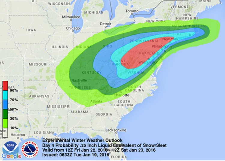
WASHINGTON — Tens of millions of Americans from Washington to Boston and the Ohio Valley could be walloped by an end-of-the-week snowstorm, meteorologists say.
Although it’s still early, computer forecast models all see a windy, strong slow-moving storm. The big questions are where and how much.
“There’s going to be a big storm. Somebody’s going to get walloped,” said Victor Gensini, a meteorology professor at College of DuPage outside of Chicago. “It does look like it’s going to be a doozy.”
Rich Otto, lead forecaster at the National Weather Service’s Weather Prediction Center, said some major cities will likely see a foot or more of snow. Other meteorologists talked about 18 inches, 2 feet and more.
At the National Weather Service office in Gray, forecasters were wary of making predictions of how much snow the big winter storm might bring to Maine, if any.
“It’s kind of a tough call at this point,” said meterorologist Michael Cempa. “Nothing is written in stone yet because there is some differences in the models. We could get some snow out of it Saturday and into Saturday night but the bulk of it will be in southern New England and points south of there.”
The storm might miss Maine altogether, or bring just some clouds and a few flurries, Cempa said.
Gensini said heavy snow is likely because the system will be slow moving. Forecasters see Saturday as the worst day.
Early Tuesday, the Weather Prediction Center said the storm could be historic, but Otto said that may have been going a bit too far.
Staff Writer Mary Pols contributed to this story.
Send questions/comments to the editors.

Success. Please wait for the page to reload. If the page does not reload within 5 seconds, please refresh the page.
Enter your email and password to access comments.
Hi, to comment on stories you must . This profile is in addition to your subscription and website login.
Already have a commenting profile? .
Invalid username/password.
Please check your email to confirm and complete your registration.
Only subscribers are eligible to post comments. Please subscribe or login first for digital access. Here’s why.
Use the form below to reset your password. When you've submitted your account email, we will send an email with a reset code.