
After several days of gloomy weather, I was rather giddy this morning with all the sunshine and comfortably cool temperatures. The landscape continues to put on its springtime colors from adequate amounts of rainfall interspersed with dry periods like today. With the drought over for now, things are slowly returning to normal.
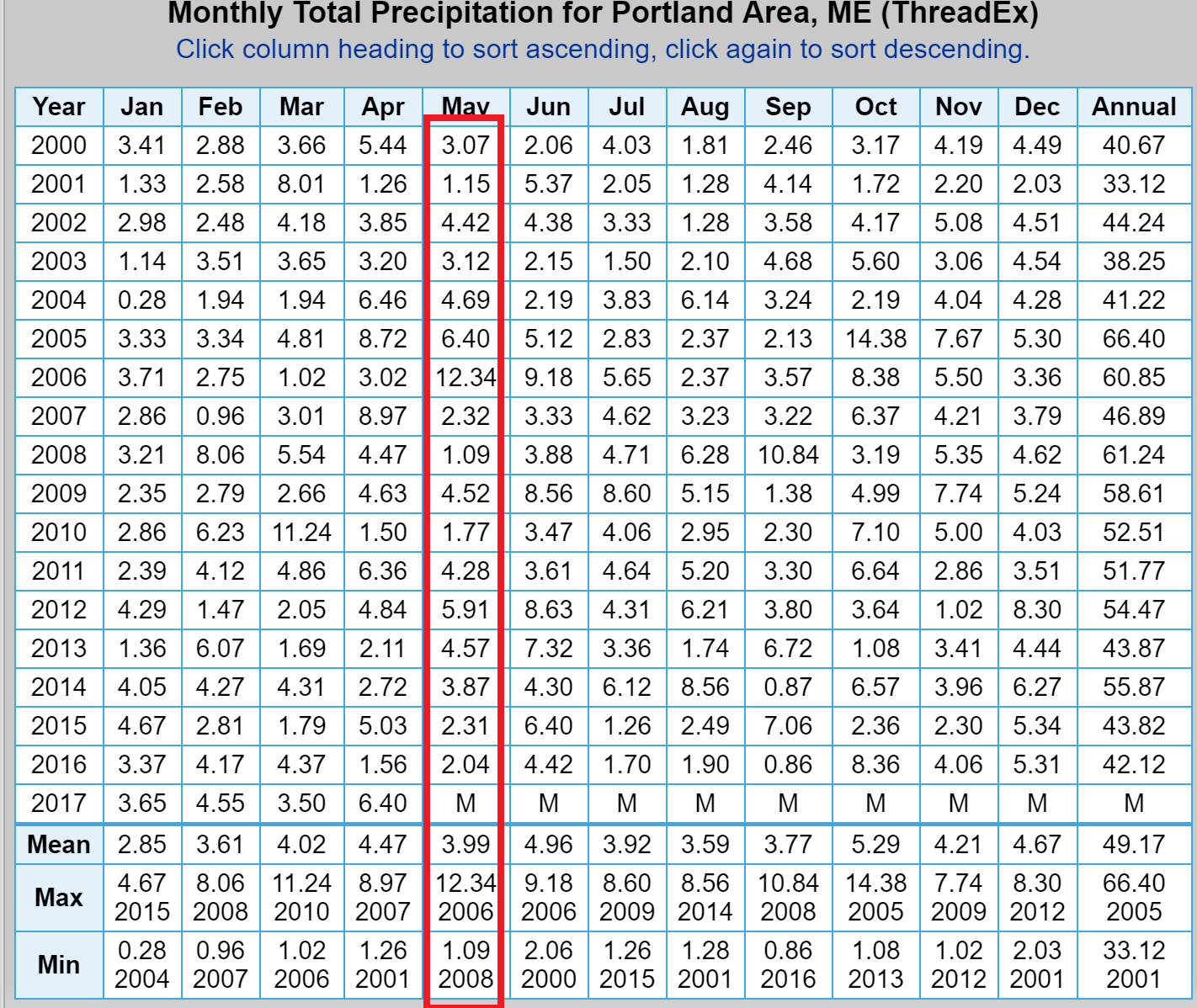
It’s important to keep perspective on what spring is typically like here in this part of New England. The past few years have brought very dry and sunny weather during May, giving us a false sense of the realities of the weather around here. Typically about 3½ to 4 inches of rain falls in May, the last time we had above-average rainfall in May was 2013. A really wet spring was 2006 when nearly 2 feet of rain fell in May and June!
I offer all of this as a lead-in to our upcoming rain event on Friday that will linger in some form through the weekend. Remember, although you will likely hear or read about showers in the forecast into early next week, only one or two days of the next five looks to be a complete washouts and those are Friday and Saturday. Even then, the morning will be mainly dry Friday and I think the afternoon could be dry on Saturday, so the washouts will be of the half-day variety.
Late this week, a storm system will move up through western New England, pulling lots of tropical moisture into the area for Friday and Friday night. Earlier this week, I used the term nor’easter because it appeared the storm might travel to our east. However, now it’s a slightly different setup, with a more western storm track – but still a wet one.
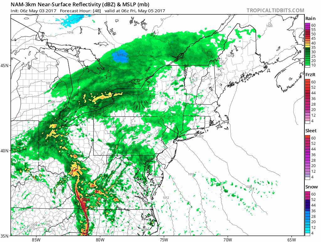
The rain arrives in earnest around noon Friday. While there can always be a shower or two earlier, the morning commute will be basically dry. Winds will pick up, but this isn’t a wind storm where we are going to have power outages or anything like that, just rather breezy.
If you have plans Friday night that call for you to be walking around, you’ll need the umbrella. Rain may be heavy at times, and urban street flooding is likely in those favored spots. Since the ground already has adequate moisture those of you with wet basements may have some issues.
Saturday morning the rain showers come to an end, but that’s not the end of the storm. A blocking pattern over Greenland will force the storm to spin over New York and Quebec for several days. This will keep the chance of showers in the forecast through Monday and not allow skies to fully clear at all. There will be times of some sunshine, but not a bright and beautiful day from sunrise to sunset. You’ll have to “make hay while the sun shines” in this pattern. Smartphone apps will likely have it raining Friday through next Wednesday; don’t be too discouraged by this.
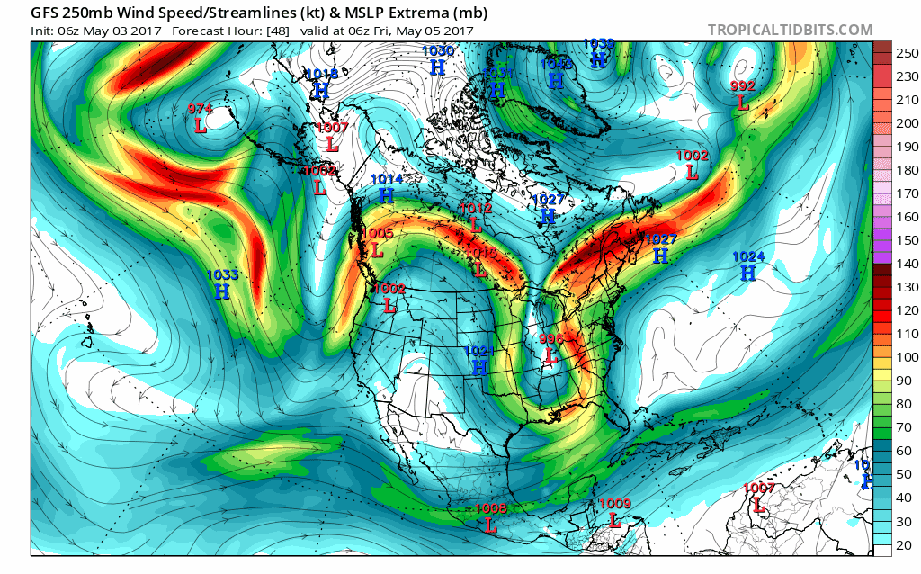
Early next week the storm will also pull down some colder air from Canada. Highs on Monday will stay in the 50s, below average for May, and there could even be snow showers in the highest elevations.
Looking even farther down the road, the chance of showers continues regularly through the middle of the month, typical and beneficial and certainly not a dry pattern. The drought of the past few years gave many the sense that spring is all sunshine and warm air – it’s not. Spring in New England is filled with chilly rains, drizzle and fog and even forecasts of warmth that never materialize.
This is why we appreciate days like today so much. They are a gift, so take your lunch outside because it’s going to rain Friday.
You can follow Dave Epstein on http://www.twitter.com/growingwisdomTwitter @growingwisdom
Comments are no longer available on this story