


Local emergency management officials have spent the last few weeks reviewing department protocols and procedures and making improvements to their flood response systems following damaging floods last month in Hallowell and Augusta.
But a review by the Kennebec Journal found that Kennebec County and some local officials didn’t respond to a flood warning the National Weather Service had issued the morning before the water encroached. Furthermore, records show that the informal alert protocol in place was ill-equipped for the sudden flooding and that some basic measures had not been taken, such as adding all relevant local officials to a group emergency email list.
Kennebec County Emergency Management Agency officials admitted they didn’t send out a flood warning from the National Weather Service on Jan. 13 because nobody in the agency saw it. As a result, local officials didn’t tell people in low-lying areas about the warning.
AGENCY EXPANDING CONTACTS LIST
Sean Goodwin, the agency’s executive director, said the organization has expanded its call list and email group, and he has recommended several smartphone applications for local officials to use to stay up to date on weather conditions in central Maine.
“Kennebec County is expanding its list so we have redundancy in each town,” Goodwin said in an interview Friday. “We can get the best information out there to a decent amount of people so this doesn’t happen again.”
The warning, which was issued around 10 a.m. that Saturday, stated that the Kennebec River was rising and that the water in Hallowell would rise to a little more than flood level – 12 feet – before dropping later that day.
The area in Hallowell that flooded that night doesn’t flood until the water level reaches 14 feet, so Goodwin said that had Hallowell officials received the warning, it wouldn’t have mattered. There was no warning that could have predicted when the ice jam that caused the severe flooding would have formed.
The day before the flood, Goodwin did send out an emailed alert to emergency management officials around the county, notifying them that heavy rain was forecast to fall Friday and Saturday. Standard protocol in this kind of situation was to send alerts via email to local emergency management officials, but those efforts have been beefed up since this flood.
“Will the Kennebec River come up? Yes,” Goodwin wrote on Jan. 12. “Will the river come over the banks? Most likely not, but keep in mind … with all the melting, we could have an ice jam anywhere on the river. We have had ice jams before, sometimes with no problems, other times with big problems.”
He said he sent the email on Jan. 12 after participating in a conference call with officials from the U.S. Coast Guard and the Maine Emergency Management Agency. Going into the weekend, he said, he was “more worried” about the threat of freezing rain and power loss.
A review of emails from Goodwin and local officials – obtained by the Kennebec Journal under a Freedom of Access request – showed no communication over the weekend between county and Hallowell officials. Beginning Jan. 16, local officials and Goodwin started making additional changes to the way they disseminate information.
There was correspondence that day between Goodwin and Augusta public works officials, and the next day with officials in Hallowell and other municipalities.
Since then, Goodwin has sent out almost daily updates to the group about local conditions and potential for complications.
“I guess things could have been better,” Goodwin said to Kennebec County commissioners last week during a regular meeting, “but I don’t see how different the outcome would be.”
Goodwin told the commission that he’s had meetings with MEMA and Hallowell officials to discuss improving communication in the future, and there are several steps that have been taken to make sure what happened in mid-January doesn’t happen again.
ICE JAMS MEAN ‘ALL BETS ARE OFF’
“We can’t stop an ice jam, and when the water comes up real fast, that’s about all the time someone will have for a warning,” Goodwin said at the meeting. “When it’s an ice jam, all bets are off.”
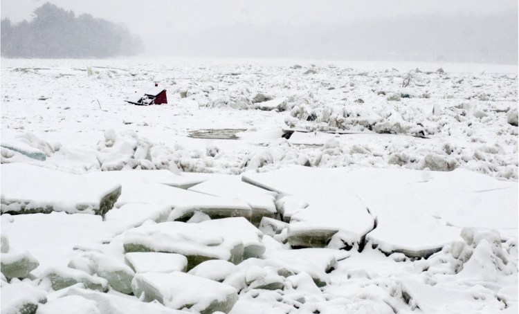
Sometime in the morning of Jan. 14, ice accumulated near Farmingdale and created a dam in the river, prompting fast-paced flooding. Basements were filled with icy water, and while no injuries were reported, there was damage to buildings and vehicles in both cities.
The damage in Hallowell was worse, and several popular businesses on Water Street, including the Quarry Tap Room, HydeOut at the Wharf and the Easy Street Lounge, spent more than a week cleaning up and working to resume operations. More than a dozen vehicles were either fully submerged and encased in ice or partially affected by the flood in Hallowell.
WATER-LEVEL GAUGE A POSSIBILITY
Some Hallowell residents and business owners said they were surprised nobody from the city, including Police Chief Eric Nason, went around alerting them of the potential for flooding. Nason, however, didn’t have any additional information to provide other than what he received from the county EMA on Friday and what he said about the potential for flooding during a TV interview Friday afternoon.
City Manager Nate Rudy said he’s been in contact with the U.S. Geological Survey about installing a water-level gauge in Hallowell so that city officials – and, in theory, residents and business owners – can get real-time information about the river, which would help emergency responders make a more informed decision in the event of potentially hazardous weather conditions.
“I feel like Hallowell followed the protocols and the (county) EMA followed their protocols based on the information they received,” Rudy said. “The reason we’re updating our protocols is because we’ve learned that we need some additional redundancies and fail-safe measures for these unforeseen and rare circumstances where the protocols we have used don’t meet the need.”
Susan Faloon, public information officer for MEMA, said each county responds differently in these types of situations, and when it’s a local incident rather than county incident or statewide incident, MEMA monitors what’s going on and is available as a resource to any municipality that needs assistance.
“Disasters start and end locally, so they are handled locally until they become more than the local EMAs can handle,” Faloon said. “We strongly encourage town officials as well as citizens to be proactive in obtaining emergency information through the National Weather Service, downloading the FEMA app or following (MEMA) on social media.”
In Augusta, one car was damaged after police spent much of that Saturday warning drivers not to park in the floodplain and even ordered two cars to be towed to safety because their owners were away on vacation. Augusta police closed Front Street that Saturday ahead of the flood. That street floods once the river reaches about 12 feet, so the city’s response to the National Weather Service and county EMA warnings probably was different from how Hallowell would have responded, Nason said.
WORKERS SPENT WEEK BREAKING ICE
“We’d like to have everybody getting the same information at the same time as I do,” the Hallowell chief said. “That way they also know what the weather is going to be and how they need to prepare for it.”
Nason said he thinks the FEMA app is something that works very well, but he said there are other applications that work well and contain the same information.
“Either one would be more than adequate to get any weather alerts fairly quickly,” he said.
The Coast Guard spent a week trying to break up the ice south of Richmond on the Kennebec River to help water flow, but a 140-foot icebreaker and three 65-foot cutters encountered challenging river conditions, including ice 5 feet thick in some spots, and they abandoned their efforts Tuesday.
The ice jam in Farmingdale remains, and Nason said as long as that’s the case, people need to be alert.
“We still need to be on high alert because the river level can fluctuate,” he said. “Nobody can predict what’s really going to happen.”
The county EMA emailed an update to its flood group Friday morning that said the river flow is being slowed by the jam, but some open flowing water in Farmingdale is slowly eroding the blockage.
“We know that the risk of flood is low, but with the ice jam still in place, all of us need to be watching the river for the sudden rise of river water as well as large ice movement,” the message said.
The message also urged anyone to call the National Weather Service’s station in Gray if they see anything happening on the river.
Taking the extra step to make sure everyone has as much information as possible is what Goodwin hopes will keep something like what happened last month from happening again.
“We’re working on it, and we’re doing better,” he said.
Jason Pafundi can be contacted at 621-5663 or at:
jpafundi@centralmaine.com
Twitter: jasonpafundiKJ
Send questions/comments to the editors.

Success. Please wait for the page to reload. If the page does not reload within 5 seconds, please refresh the page.
Enter your email and password to access comments.
Hi, to comment on stories you must . This profile is in addition to your subscription and website login.
Already have a commenting profile? .
Invalid username/password.
Please check your email to confirm and complete your registration.
Only subscribers are eligible to post comments. Please subscribe or login first for digital access. Here’s why.
Use the form below to reset your password. When you've submitted your account email, we will send an email with a reset code.