

And just as the long holiday weekend marked summer’s unofficial start in the U.S., Alberto gave it the unofficial start of what forecasters recently predicted would be an active hurricane season.
The National Hurricane Center in Miami said at 11 a.m. EDT Monday that Alberto was maintaining its strength as it approached the Florida Panhandle and was centered about 50 miles (80 kilometers) south of Panama City, Florida. The storm that was expected to make landfall later Monday had maximum sustained winds of 60 mph (95 kph) and was moving north at 8 mph (13 kph).
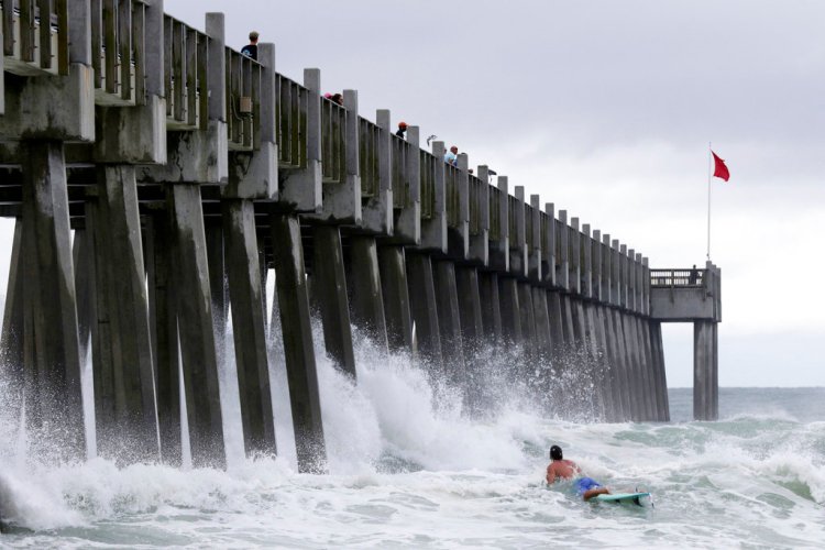
Forecasters warned of life-threatening surf conditions, the possibility of a few brief tornadoes in much of Florida and parts of Georgia, South Carolina and Alabama. And, it said, heavy rains are also expected in many areas.
“Given the short period of time before Alberto makes landfall, its overall ragged appearance, and proximity to dry air, little change in strength is expected before the subtropical storm reaches the coast,” said John Cangialosi, a hurricane specialist at the hurricane center.
Once Alberto is inland, and deprived of the warm waters that fuel tropical weather systems, the storm was expected to steadily weaken. A subtropical storm like Alberto has a less defined and cooler center than a tropical storm, and its strongest winds are found farther from its center. Subtropical storms can develop into tropical storms, which in turn can strengthen into hurricanes.
Rough conditions were expected to roil the seas off the eastern and northern Gulf Coast region through Tuesday.
Lifeguards posted red flags along the white sands of Pensacola Beach, where swimming and wading were banned amid high surf and dangerous conditions. Gusty showers began lashing parts of Florida on Sunday, and authorities warned of the possibility of flash flooding.
The hurricane center said a tropical storm warning was in effect from the Suwannee River in Florida to the Alabama-Florida state line.
About 400 customers along Florida’s Tampa Bay and in the Panhandle were without power Monday morning, according to Florida’s Division of Emergency Management.
Mark Bowen, the Bay County Emergency management director, said Alberto’s biggest threat would be its heavy rains, with forecasts of anywhere from four to 12 inches (10 to 30 centimeters) of rain in some areas. Storm surge flooding was less of a concern because Alberto’s arrival would not coincide with high tide, he said.
Some tourists said the rainy weather would not dampen their vacations.
Janet Rhumes said her group of friends from Kansas had been planning their Memorial Day weekend on Navarre Beach since October, and no tropical storm could deter them.
“We’ve never seen one before and we’re here celebrating a friend’s 20th birthday,” Rhumes told the Northwest Florida Daily News. “So how often can you say you rode a storm out?”
Rhumes said her group prepared for the storm by stocking up on groceries.
“We’re going to play cards and if there’s a break, we’ll head down to the beach,” she said. “We’ll hang out and see how it goes.”
The storm’s approach triggered mandatory evacuations of some small, sparsely populated Gulf Coast barrier islands in one Florida county. The Florida Division of Emergency Management said in a statement Sunday that a mandatory evacuation has been issued in Franklin County for all barrier islands there and those in the county living directly on the coast in mobile homes or in recreation vehicle parks.
In Taylor County, there were voluntary evacuations for those in coastal zones and beach communities, mobile homes, RV parks and low-lying areas. In Gulf County, T. H. Stone Memorial St. Joseph Peninsula State Park began evacuations Sunday morning.
In Miami, organizers called off the sea portion of the Miami Beach Air & Sea Show on Sunday because of heavy rain and rough waters. And in the Tampa Bay area on the central Gulf Coast, cities offered sandbags for homeowners worried about floods.
The National Oceanic and Atmospheric Administration released a hurricane season forecast Thursday that calls for 10 to 16 named storms, with five to nine hurricanes. One to four hurricanes could be “major” with sustained winds of at least 111 mph (178 kph).
If that forecast holds, it would make for a near-normal or above-normal season. An average hurricane season produces 12 named storms, of which six become hurricanes, including three major hurricanes.
Send questions/comments to the editors.

Success. Please wait for the page to reload. If the page does not reload within 5 seconds, please refresh the page.
Enter your email and password to access comments.
Hi, to comment on stories you must . This profile is in addition to your subscription and website login.
Already have a commenting profile? .
Invalid username/password.
Please check your email to confirm and complete your registration.
Only subscribers are eligible to post comments. Please subscribe or login first for digital access. Here’s why.
Use the form below to reset your password. When you've submitted your account email, we will send an email with a reset code.