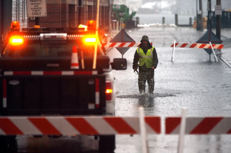
Weather forecasters were expecting much of the heavy rain that caused flooding Friday – the first day of winter – to mostly wind down by Saturday morning.
William Watson, a meteorologist with the National Weather Service in Gray, said that the fog is likely to linger into the morning Saturday, but that, along with the chance of showers, should be swept out of the area when a cold front moves through during the afternoon.
Watson said that the winds will continue throughout the day, which should help evaporate any moisture remaining on the roadways.
“You could see some slick spots in some places where the (precipitation) hasn’t run off, but we’re not expecting widespread icing,” he said.
A flood watch was in effect for parts of Maine, with multiple inches of rain in the forecast Friday and astronomical high tides expected throughout the weekend.
As of 9 p.m. Friday, 1.07 inches of rain was reported at the Portland International Jetport, while 1.4 inches was reported in Gray, 1.14 inches in Lewiston-Auburn and 1.48 inches in Augusta, Watson said.
The weather service was predicting 1 to 3 inches of rain in the southern and western parts of the state by Saturday afternoon.
“These amounts could lead to nuisance flooding of urban and low-lying areas,” the alert said. “In addition, warm temperatures and runoff will likely lead to ice break up on rivers, possibly leading to ice jams and flooding.”
In Portland, city officials warned residents about the forecast. Even without the rain, high tides were expected to exceed 11 feet Saturday through Tuesday, more than a foot above a typical high tide.
“Please make sure to adhere to any streets that are barricaded and do not attempt to drive through flooded streets,” the city alert said.
Portland workers placed barricades near Franklin Street on Friday morning to keep traffic from entering Somerset Street, a low-lying section of the Bayside neighborhood that typically floods when high tides coincide with heavy rains.
Hallowell officials expected the Kennebec River water level to surpass the 12-foot flood stage and crest between 16 and 21 feet.
In Augusta, city officials planned to close parking along the river on Front Street, in addition to setting up barricades and electronic message boards.
“We need to err on the side of caution,” Augusta Fire Chief Roger Audette wrote in a Thursday email chain among city officials. “Remember the frozen cars in Hallowell last year.”
In January, as many as 20 cars were destroyed and 24 businesses were damaged after water levels rose because of an ice jam.
The Kennebec Journal reported that a breakdown in communication between the county and local emergency management officials led to downtown residents and business owners not being wholly informed.
A wind advisory was also in place until the early hours of Saturday.
Send questions/comments to the editors.


Success. Please wait for the page to reload. If the page does not reload within 5 seconds, please refresh the page.
Enter your email and password to access comments.
Hi, to comment on stories you must . This profile is in addition to your subscription and website login.
Already have a commenting profile? .
Invalid username/password.
Please check your email to confirm and complete your registration.
Only subscribers are eligible to post comments. Please subscribe or login first for digital access. Here’s why.
Use the form below to reset your password. When you've submitted your account email, we will send an email with a reset code.