

From the Palmer Divide to the Plains Wednesday, an exceptionally-powerful “bomb cyclone” brought 100 mph wind gusts and conditions rivaling those of a hurricane, except with blinding snow in many places.
The cyclone of “historic proportions,” according to the National Weather Service, is racing into Upper Midwest. Blizzard conditions, which stranded more than 1,000 motorists in Colorado Wednesday and shut down Denver International Airport, continue to plaster parts of the Dakotas and northwest Minnesota.
A severe storm threat extended on the massive cyclone’s south and east side, from northern Mississippi and Alabama into southern Michigan. “Damaging winds and a few tornadoes will be possible along with large hail,” the Weather Service said Thursday.
“Major damage” was reported from a tornado near Paducah, Kentucky, Thursday morning. The twister narrowly missed the Weather Service office in Paducah, requiring meteorologists to seek shelter while the Weather Service office in Louisville briefly took over operation.
In the transition zone between the warm and cold sectors of the storm, the combination of downpours and melting snow poses flooding concerns in eastern Nebraska and Minnesota, southeast South Dakota, Iowa, Wisconsin and northern Michigan. Ice jams are a major concern along rivers in this region.
By Friday, the storm effects on the Lower 48 are expected to turn tamer, as it lifts into northeast Canada. Mainly just rain showers are expected as the storm’s cold front pushes toward the Eastern Seaboard.
But the storm will leave behind a remarkable and, in some areas, a destructive and costly legacy.
On Tuesday and Wednesday, the storm came in different phases, transitioning from violent thunderstorms on its southern flank to a full-fledged blizzard on its north and west side. In the middle, soaking rain on top of snowfall and icy rivers led to flooding.
An enormous area was buffeted by powerful winds, which exceeded 100 mph in a few spots.
The storm began with a broken line of severe thunderstorms that swept from eastern New Mexico to eastern Texas late Tuesday night and early Wednesday. Three tornadoes touched down, including an EF-2 near Dexter, New Mexico. The National Weather Service line Albuquerque called the tornado – which stayed on the ground for 15 miles – the “earliest known EF-1 or stronger tornado in the state.” Baseball-size hail also pummeled Ward County, Texas.
Individual storms and clusters merged into a violent squall line that left a 500 mile-long path of wind damage as far east as Dallas. A gust to 78 mph was measured at the Dallas/Fort Worth International airport, while nearby stations like Grand Prairie and Granbury hit 80 mph. A “logistics facility” at the airport lost part of its roof, according to the Weather Service, while the roof was peeled off of an Amazon Warehouse facility.
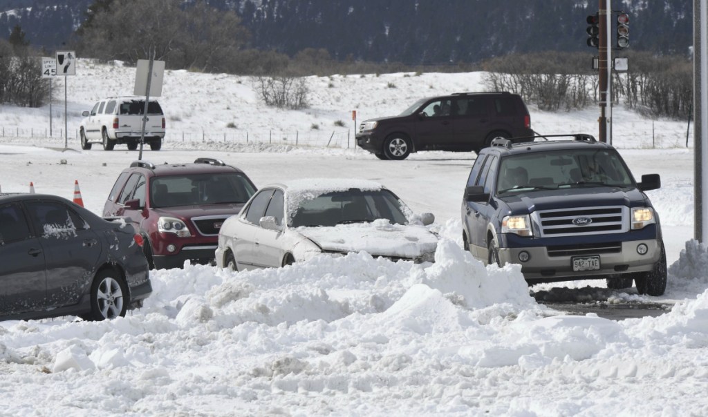
Barometric pressures continued to fall as the storm system rapidly “deepened” Tuesday night. Temperatures in Denver dropped from 62 degrees Tuesday to 26 degrees by lunchtime Wednesday, light rain transitioning to a heavy, wet snow. The cement-like paste quickly made roads impassible.
Despite pleas from the National Weather Service that motorists “could become stranded” if they ventured out, more than 1,000 were trapped by the conditions according to CNN. Colorado Gov. Jared Polis activated the National Guard, which rescued more than three dozen people who became stuck in the treacherous conditions.
“We’d have to go something way back to find something that matched the wind aspect of this event,” said Greg Hanson, warning coordination meteorologist at the National Weather Service in Denver. “It’s Colorado. We can handle the snow. But the wind has been extremely impactful.”
The heftiest snow came down in the mountains, with Wolf Creek Pass along Highway 160 reporting 45 inches. Fourteen inches piled up in Cheyenne, Wyoming, its fourth heaviest single-day snowfall on record.
Officially, Denver International Airport only picked up 7.1 inches of snow, but blowing and drifting contributed to the disaster that unfolded on area highways Wednesday afternoon.
“One volunteer group was out all night rescuing stranded motorists,” said Hanson. “Nobody really stopped.”
Winds gusted to 80 mph at the airport while visibility dropped to just 0.13 miles just before 2 p.m. Wednesday. The airport reported wind gusts topped 57 mph for six consecutive hours.
“It’s only the fourth time I can remember [that] the Denver airport has shut down all four runways,”Hanson said.
Nearby Centennial Airport recorded winds gusting to near 70 mph along with thundersnow and freezing fog around noontime.
Seventy miles to the south, Colorado Springs Airport gusted to 97 mph amid blinding whiteout conditions.
Power outages were also an issue, Hanson said. At the height of the storm, XCel Energy reported more than 400,000 customers over Colorado were without electricity.
“It was a very well-predicted storm. We’re pleased by how our forecasters handled it, and the media has been great in getting the word out.”
Models had hinted this storm would become a meteorological “bomb” with its central barometric pressure dropping 24 millibars or more in 24 hours. After a bout of rapid intensification, air pressures in many locations rivaled those of a Category 2 hurricane. (Typical fair-weather air pressure is about 1010-1015 millibars.)
Pueblo, Colorado, unofficially dropped to their lowest air pressure on record. The lower the pressure, the more intense the storm. It’s an indicator that the atmosphere weighs less over a given location, the removal of air creating a vacuum effect. That sucks in surrounding air and results in damaging winds.
Lamar, Colorado, may set a state record with its 970.4 millibar pressure reading.
Dodge City, Kansas, also saw its lowest pressure record broken, the barometer dipping the lowest it has in the past century.
The incredible pressure gradient across the region meant damaging winds would continue across most of the High Plains and mountains.
Winds hit 103 mph in Pine Springs, Texas, and 104 mph in San Augustine Pass, New Mexico, while a number of locations across Colorado hit 90 mph.
The winds toppled high profile vehicles in Texas and, in Logan, New Mexico, blew 26 rail cars off a bridge. No injuries were reported from the incident.
While the severe storms, blizzard, and high winds captured most of the storm’s headlines, its heavy rainfall led to serious flooding and ice jams where the snow transitioned to rain in eastern Nebraska and South Dakota as well as western and central Iowa.
“The Highway Superintendent in Yankton County says 75 perceent of the roads in the county are either under water or have water running over them in spots,” tweeted Tom Hanson, an anchor for news affiliate KDLT in Sioux Falls, South Dakota.
The Des Moines Register reported “30-foot ice slabs” flowing down rivers, which damaged bridges, and “severe flooding problems” that closed highways and roads.
storm.
Send questions/comments to the editors.

Success. Please wait for the page to reload. If the page does not reload within 5 seconds, please refresh the page.
Enter your email and password to access comments.
Hi, to comment on stories you must . This profile is in addition to your subscription and website login.
Already have a commenting profile? .
Invalid username/password.
Please check your email to confirm and complete your registration.
Only subscribers are eligible to post comments. Please subscribe or login first for digital access. Here’s why.
Use the form below to reset your password. When you've submitted your account email, we will send an email with a reset code.