

The U.S. Coast Guard expected to start its ice-breaking mission on the Kennebec River Thursday, moving up the operation by about four days because of an early spring storm forecast to move through region starting late Thursday or early Friday.
The storm is likely to bring a half-inch to an inch of rain across central Maine on Thursday, and perhaps a little more on Friday.
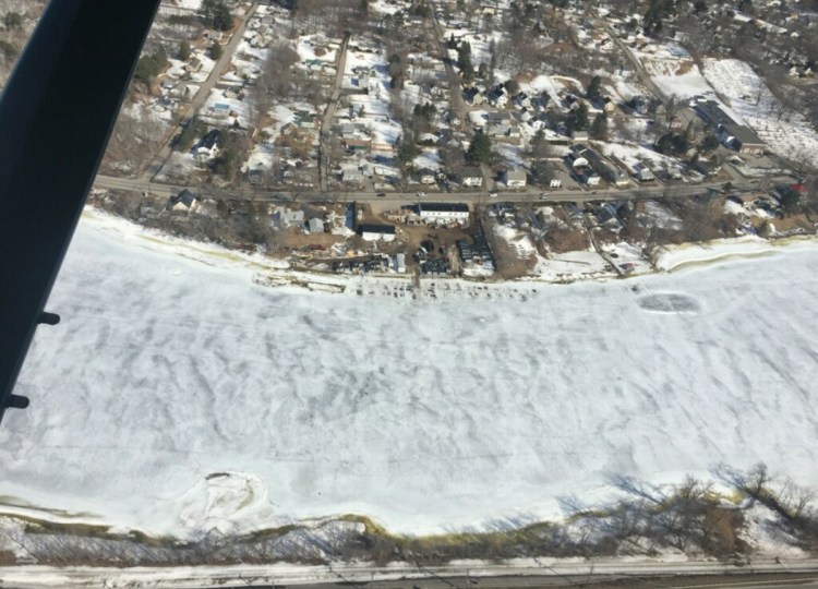
While there are ice-free stretches on the Kennebec River, particularly between Waterville and Augusta, other parts of the river are still covered with ice.
“When we get increased flow in the river, the ice needs some place to go,” said Sean Goodwin, Kennebec County Emergency Management Agency director.
The ice-breaking operation is expected to open a channel, starting at Gardiner, to allow the ice to flush down the river and into the ocean.
“The ice rises and lowers with the tide; hence the cracks you can see near the shore,” Goodwin said.
When the ice starts to break up, the slabs can form jams, he said, resulting in flooding. Goodwin said it can be hard to judge where the jams will occur.
The decision to move up the ice-breaking came Wednesday during a conference call among the National Weather Service, the U.S. Coast Guard, the Maine Emergency Management Agency and county officials.
The Coast Guard announced it’s sending two cutters – the Thunder Bay, a 140-foot tug stationed in Rockland, and the Shackle, a 65-foot tug stationed in Portland.
A second operation will clear ice on the Penobscot River.
“Our ice-breaking crews have done a tremendous job ensuring the waterways of Maine and New Hampshire remained open and safe throughout the season,” Lt. Matthew Odom, chief of the Waterways Management Division for the Coast Guard Sector Northern New England, said in a news release Wednesday.
“As temperatures rise, we intend to clear significant portions of the Penobscot and Kennebec rivers of ice to mitigate flood risks,” Odom said.
Local emergency managers and the Maine State Warden Service checked to make sure ice fishing shacks have been removed, and the Division of Marine Resources assessed ice conditions from the air.
James Brown, meteorologist with the National Weather Service in Gray, said the storm is on track to bring rain to Maine and New Hampshire, and probably snow to Vermont.
Brown said a lot of the rain probably will be absorbed by the snowpack. And while the daytime temperature will be in the 40s, it will drop below freezing at night, and that’s expected to slow the melting process.
Every year around this time, the river advisory group, made up of federal, state and local officials, meets to assess the water content of the snowpack and ice conditions on the state’s major rivers. Historically, many of the river’s worst floods have occurred around this time.
“In our line of work,” Goodwin said, “we plan for the worst.”
Jessica Lowell can be contacted at 621-5632 or at:
jlowell@centralmaine.com
Twitter: JLowellKJ
Send questions/comments to the editors.

Success. Please wait for the page to reload. If the page does not reload within 5 seconds, please refresh the page.
Enter your email and password to access comments.
Hi, to comment on stories you must . This profile is in addition to your subscription and website login.
Already have a commenting profile? .
Invalid username/password.
Please check your email to confirm and complete your registration.
Only subscribers are eligible to post comments. Please subscribe or login first for digital access. Here’s why.
Use the form below to reset your password. When you've submitted your account email, we will send an email with a reset code.