

KINGS CANYON NATIONAL PARK, California — Earlier this week I crossed a sturdy bridge over the roaring South Fork of the San Joaquin River and entered Kings Canyon National Park. A day later and 4,000 feet of continuous climbing over 18 miles, I stood happily atop Muir Pass.
Carey Kish gives a big thumbs-up atop the 11,979-foot Muir Pass, named for conservationist and writer John Muir. The Muir Hut is behind him. Photo courtesy of Carey Kish
The 11,969-foot pass is named for John Muir, the dedicated naturalist, ardent conservationist and prolific writer, among other notable talents. A stone hut, erected in 1931 by the Sierra Club, adorns the pass.
Muir Pass is a setting so spectacular that you could easily imagine yourself in the Karakoram or Himalaya, such is the raw wildness of the surroundings. Harsh as this desolate place appears, though, there’s a softer side if you look closely, that of delicate wildflowers and slender grasses, marmots and mice, and flitting little birds.
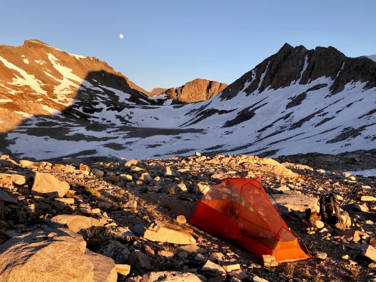
I pitched my tent amid the rocks 200 feet from Muir’s hut and enjoyed the finest camping of the trek, complete with a lovely moonrise, sweet sunset, brilliant stars and not a breath of wind.
In his 1911 classic, “My First Summer in the Sierra,” Muir wrote: “Another glorious Sierra day in which one seems to be dissolved and absorbed and sent pulsing onward we know not where. Life seems neither long nor short, and we take no more heed to save time to make haste than do the trees and the stars. This is true freedom, a good practical sort of immortality.”
Nearly 1,700 miles and 4 1/2 months into this journey, I stride forth with John Muir’s spirit deep within me and feel the freedom he felt, breathing deeply the mountain air, drinking copiously of the crystal-clear waters, and feeding voraciously on the incomparable natural beauty all about me.
PCT hiker “Ranger” is dwarfed by the barren rock and huge snowfields south of Sonora Pass. Photo by Carey Kish
The high elevation Sierra fun began in earnest around Highway 108 at 9,624-foot Sonora Pass, where the Pacific Crest Trail climbs to just shy of 11,000 feet on its meandering route around Leavitt Peak. The wide-open terrain of barren rock, dozens of snowfields and the occasional green patch of dwarf pines offered limitless panoramic views.
The PCT enters Yosemite National Park at Dorothy Lakes Pass, then descends to follow Falls Creek for 10 easy miles. At Wilma Lake, the trail turns east and starts across the “Yosemite Washboard,” a 40-mile stretch of steep and strenuous ridge, and pass climbs in quick succession.
The late snowmelt has meant a delayed crop of mosquitoes, and while they were only bothersome up to this point, in Yosemite the beasts were ferocious. Long-sleeved shirt, long pants and a slathering of DEET became my daily modus operandi, minus the head net I’d jettisoned several weeks ago to “save weight.” Yikes.
At Tuolumne Meadows, the PCT meets the popular John Muir Trail, which parallels and coincides with the big trail for the next 200 miles. From Lyell Canyon the path switchbacks past perfect blue-green lakes, gushing creeks, and clumps of vivid heather and penstemon to Donahue Pass. I camped in the wide open at 10,800 feet, a scant 200 feet below the icy pass, and enjoyed a wonderful evening in the shadow of 13,114-foot Mt. Lyell, Yosemite’s highest summit.
It’s easy to lose track of where you are in this grand landscape of granite and snow, meadows and big trees. Yosemite gave way to the Ansel Adams Wilderness, then somewhere amid the head-spinning scenery around Thousand Island Lake, Mt. Ritter and Banner Peak, I think I passed a sign for the John Muir Wilderness. It’s all gloriously the same to me.
The lovely Marie Lakes as viewed from the PCT atop 10,913-foot Selden Pass. Photo by Carey Kish
The thundering Tuolumne Falls in Yosemite National Park as viewed from the side trail to Glen Aulin High Sierra Camp in Yosemite National Park. Photo by Carey Kish
These days in the High Sierra are as demanding as any on the hike. I could figure the elevation gain and loss, but I won’t. It’s a lot. The sweat and toil is worthwhile, however, because of the truly special wild places I’ve walked through and camped at, like Lake Aloha, Carson Pass, Sonora Peak, Tuolumne Falls, Lake Virginia, Marie Lakes, Evolution Lake, Kings River (hint: put them on your backpacking to-do list) and many others too numerous to mention.
About 120 miles of the Sierra remain, then it’s back to Oregon for the final northbound leg of the PCT to Washington and the Canadian border.
Carey Kish of Mount Desert Island thru-hiked the Appalachian Trail in 1977 and 2015, and completed the 1,100-mile Florida Trail in 2017. Follow Carey’s PCT adventures on Facebook @Carey Kish.
Send questions/comments to the editors.

Success. Please wait for the page to reload. If the page does not reload within 5 seconds, please refresh the page.
Enter your email and password to access comments.
Hi, to comment on stories you must . This profile is in addition to your subscription and website login.
Already have a commenting profile? .
Invalid username/password.
Please check your email to confirm and complete your registration.
Only subscribers are eligible to post comments. Please subscribe or login first for digital access. Here’s why.
Use the form below to reset your password. When you've submitted your account email, we will send an email with a reset code.