

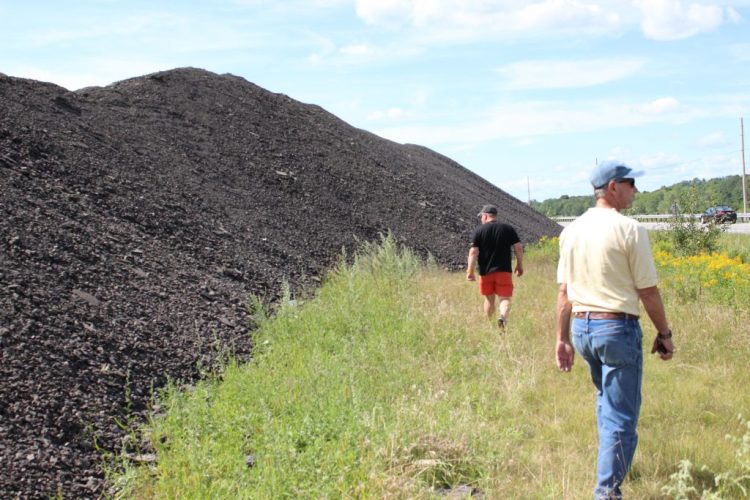
DURHAM — Durham and the Maine Department of Transportation are at odds over a large pile of asphalt millings that has been growing on state-owned land alongside Route 136 for over a year.
The more asphalt that is dumped, the closer the pile moves to the bank of the Androscoggin River, something that town officials worry could damage the river that has made so much progress under the Clean Water Act. Transportation officials say that the pile is a “more than adequate” distance from the water and that the department has the authority to dump asphalt there.
The Department of Transportation is building the pile of asphalt millings with plans to construct a mill to recycle the asphalt and use it to repave and add shoulders to roughly 16 miles of Route 9, DOT engineer Bill Doukas said. It’s a project he says will “provide a safe, reliable transportation improvement” with significant cost savings. Reconstruction of the road would cost about $4 million per mile, he said, while highway rehabilitation using recycled asphalt only costs about $350,000 per mile.
Robert Forrest, Durham’s code enforcement officer said Durham was blindsided by the project.
He said state officials never applied for any land use permits – the state owns the lot where pile is located — and never told anyone in the town office what the project was. He only found out what was happening after residents started complaining and he called to investigate, he said.
Forrest filed a “notice of violation for corrective action” against the DOT on Aug. 9 on the grounds that no industrial use is allowed in the resource protection zone without a conditional use permit for earthmoving activities greater than 500 cubic yards.
Doukas responded to the notice in a letter dated Sept. 10, saying it was a “well-established general rule of law that state governments are not subject to regulation by local municipalities.”
Forrest is not convinced. After speaking with the town attorney, he said Thursday that he plans to file a second violation notice “specific to shoreland zoning,” citing the prohibition of petroleum products, which include asphalt, from a commercial or industrial business in the shoreland zone, as well as the lack of public notification or public hearing for the town.
Durham resident Benjamin Redmond can hear the construction noise from his house, and while he is concerned about the potential health risks of inhaling the black dust that has started accumulating at his home, he says it’s the Androscoggin River just across the road that he is concerned about.
According to the Mandatory Shoreland Zoning Act, all municipalities must establish zoning controls in areas within 250 feet of the normal high-water line of any great pond or river, and within 75 feet of the normal high-water line of a stream.
The Department of Transportation acknowledged Redmond’s concerns.
“We are aware of concerns from a few vocal residents who have been in contact with our department for more than a year now,” Doukas said in an email.
He is confident there are “no chemical or excess contaminant issues at the Durham site,” and that “the material in the pile of millings is the exact same material that makes up Route 136 and every road in our state, and (is) considered inert material by DEP definition.” Workers have also placed what Department of Environmental Protections spokesman Dave Madore called “erosion control measures” to help protect the river from any impact.
According to DOT officials in response to Redmond’s questions, “We did contact our partners at DEP when this issue came up and found that we are required to keep this stockpile 75 feet away from the high water mark of the Androscoggin River.”
Doukas said in an email to The Times Record on Sept. 11 that the pile was “more than double the required distance from the high-water mark.” Later, on Sept. 18, he said the pile had grown but was “still within the DEP-accepted parameters.”
Doukas said the milling pile was 65 feet from the guardrail, with another 25 feet to the very beginning of the rip rap — boulders and stones lining the slope down to the river’s edge. “It is unsafe to traverse rip rap that large, but I could estimate there was another 30-40 feet from that point to the water’s edge. The total distance from the milling pile to the water’s edge is about 120-130 feet.”
Redmond does not think the numbers add up. Last month he went out with his 300-foot tape measure and measured from the high water line to the edge of the pile. It was 68 feet, he said.
The pile is also within the 100-year floodplain. According to the ordinance, “Before any construction or other development, including the placement of manufactured homes, begins within any areas of special flood hazard established … a Flood Hazard Development Permit shall be obtained from the Code Enforcement Officer. This permit shall be in addition to any other permits which may be required pursuant to the codes and ordinances of the (town).”
“They could have been way more proactive at the beginning, but they weren’t,” Forrest said. “The planning board should have been able to review this, but they weren’t offered the chance. Nobody else in the town could do that without going through the planning board.”
Remond agreed.
“Should a private citizen doing anything not authorized in the shoreland zone law, they would be taken to task and forced to pay large fines. Seems like a double standard to me and it has always been my understanding the law applies to all citizens, businesses and state agencies alike,” he said in an email to Durham Rep. Braden Sharpe.
“The DOT is playing fast and loose with the rules and that should be a concern to other landowners that follow the rules,” Redmond said.
hlaclaire@timesrecord.com
Send questions/comments to the editors.

Success. Please wait for the page to reload. If the page does not reload within 5 seconds, please refresh the page.
Enter your email and password to access comments.
Hi, to comment on stories you must . This profile is in addition to your subscription and website login.
Already have a commenting profile? .
Invalid username/password.
Please check your email to confirm and complete your registration.
Only subscribers are eligible to post comments. Please subscribe or login first for digital access. Here’s why.
Use the form below to reset your password. When you've submitted your account email, we will send an email with a reset code.