

Our historical society in South Portland documents the history of the entire community, although if you were to review the subject matter that has appeared in this column since 2005, you’d surely find that the history topics are more often about history on our east end.
There’s no secret about why that happens – South Portland’s east side has been home to two lighthouses, Fort Preble, numerous shipyards, and historically, a much higher population of residents. That often means that we have a wealth of material covering areas to the east, and yet when I seek out a photo to run about some history topic related to Thornton Heights, Crockett’s Corner, Clark’s Pond or other western areas, we have a much smaller selection of historic photos to choose from.
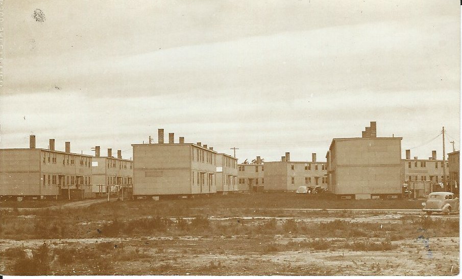
The two-story buildings shown in 1945 were part of Long Creek Terrace, a World War II government-funded housing complex. Within view of the housing complex was the ice house at Clark’s Pond. Very few photos of the ice house exist today. Those with photos of the ice house are encouraged to contact the South Portland Historical Society. South Portland Historical Society photo
The entire Maine Mall area, prior to 1969, was very sparsely settled, with a few farms along the old Payne Road (now called Maine Mall Road). The mall itself has always proclaimed how it was built on the site of an old piggery or two.
We do know there was a pig farm roughly in the area of the intersection of Gorham Road and Maine Mall Road, but in the 15-plus years that I’ve been at the historical society, I have searched for photos of that pig farm and have never found one.
Likewise, if you look at a wider area, picking up the corridor that is now Western Avenue (built in the 1960s) and Redbank (built during World War II), if you look at the area any time before 1940, you see only the occasional home and farm – and photographs are scarce.
Even in Thornton Heights, where we had many businesses along Main Street/Route 1, which used to be the major highway through Maine, it seems that not many photos exist today. We have either no or limited photographs of some places where we know residents used to hang out: Brigham’s Variety, Burnett’s Market, E.G. Shettleworth Co. 5 & 10 Store, Fehlau’s Hardware, D & E Potato Chips, Nappi’s Barber Shop, the Snak-a-Roo ice cream stand, Mrs. Shaw’s Doughnut Shop, Se-Lect Foods restaurant, Black’s Variety, and Mitchell’s fruit and produce stand.
Even very popular places like the A & W Restaurant and Friendly’s Ice Cream on Main Street are incredibly under-represented when it comes to photograph documentation.
We are hoping that you can help us document more of South Portland’s history on its western end. Do you have any photographs that show images of any areas from Cash Corner toward our city line at Scarborough? Do you have any friends that you can contact for us, who might have lived or worked here but who have moved away?
If you can help us with any leads, or if you or a friend has information to share, the South Portland Historical Society can be reached in multiple ways: by phone at 207-767-7299, by email at sphistory04106@gmail.com, by message on Facebook, or by mail at 55 Bug Light Park, South Portland, ME 04106. Thank you.
The accompanying photograph shows some of the buildings at Long Creek Terrace. That 27-acre World War II housing complex was once located on the site where you’d find Home Depot and the Eastpoint Christian Church today. One of the best descriptions of that housing complex can be found in the 10th anniversary report of the South Portland Housing Authority.
It read: “Just a quarter of a mile from Redbank Village, Long Creek Terrace provided 500 homes for families in 74 dwelling buildings of six to eight families each. These were two-story buildings with flat roofs. There were three, four and five bedroom units, some of them furnished. Long Creek Terrace housed the families of war workers from May of 1943 until it closed in April, 1946. The Community Building contained 3,496 square feet of floor space, was constructed of cement blocks and was arranged so that rooms could be divided or combined for various activities. During its short period of use, it was a very busy place. The Administration Building adjoined the Community Building by a breezeway.”
After the war ended, in 1945, the shipyards closed and families began to move out of South Portland. At the same time, though, veterans were returning from the war to overcrowded communities and colleges, so a new use was found for the wartime housing in South Portland by moving it under the Title V program to other communities to provide housing for veterans and their families. The buildings from Long Creek Terrace were moved to Cambridge, Massachusetts, to the University of Maine, and also some to Colby College.
Kathryn Onos DiPhilippo is executive director of the South Portland Historical Society.
Comments are not available on this story.
Send questions/comments to the editors.
