

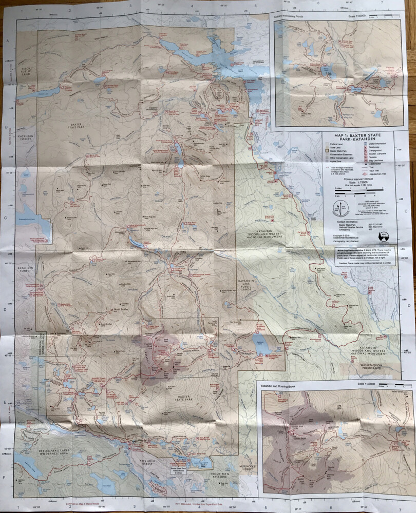
For a beginner’s guide to map reading, use the AMC Maine Mountain Guide Map 1: Baxter State Park—Katahdin. Carey Kish photo
A paper map is one the 10 essentials hikers should always carry on every hike (another is a compass, of course). Like any piece of gear, though, maps are only useful if you know how to use them.
Maps are a small-scale representation of the larger reality out there on the ground and pack a lot of information into the confined space of a paper sheet. Do you know what it all means and can you interpret it properly in the field? A review of map reading basics will help you be more comfortable with your surroundings in the woods and increase your margin of safety.
There are many different types of maps, but the two most useful for hikers are topographical maps, like those produced by the U.S. Geological Survey, and recreational maps or “trail maps,” like those produced by National Geographic/Trails Illustrated, the Appalachian Mountain Club and others. For this exercise, we will go to the AMC Maine Mountain Guide, Map 1: Baxter State Park – Katahdin (above)

The legend for the map for Baxter State Park – Katahdin. Carey Kish photo
On the right side of the map is the legend, the key to the many features depicted by the map. Orient the map so the type reads from left to right. Look for the true north arrow and you’ll see that the map is oriented with north at the top, west to the left, east to the right and south at the bottom.
Halfway down the legend is the scale. This ratio of distance is 1:75000, meaning that one inch on this map is equivalent to 1.184 miles (75,000 inches) on the ground. Two scale bars, one in miles and another in kilometers, aid in measuring distance.
The legend’s upper-left column shows what the six color schemes on the map represent, while the upper-right column shows the 10 symbols used. Immediately below is contour interval, which refers to the elevation difference – 100 feet – between the wavy brown lines (or “contour lines) on the map. Tight-spaced contour lines indicate steep terrain; wider lines indicate gentler terrain.
The large peach-colored area outlined in brown is Baxter State Park. The yellow-shaded area to its east is federal land, the Katahdin Woods and Waters National Monument. In pink to the west and south of Baxter are conservation easements (Katahdin Forest), while the green-shaded area is other conservation land (Debsconeag Lakes Wilderness Area). The purple shading represents the extent of the Alpine zone on Katahdin.
Two outlined rectangular areas on the map proper refer to the inset maps, one in the upper right for “Kidney and Daicey Ponds” and the other in the lower right for “Katahdin and Roaring Brook,” which show detail at a larger scale (1:40000).
Anything shaded blue is water, from rivers and streams to lakes and ponds. Roads are marked by two thin black solid or dashed lines. Trails are shown as thin red lines, except for the AT and the IAT, which are thicker red lines.
Blue capital letters and numbers along the map borders correspond to the light gray lines that crisscross the sheet and form a grid system used for locating places on the map. We’ll use these coordinates to find and identify some of the other major map features.
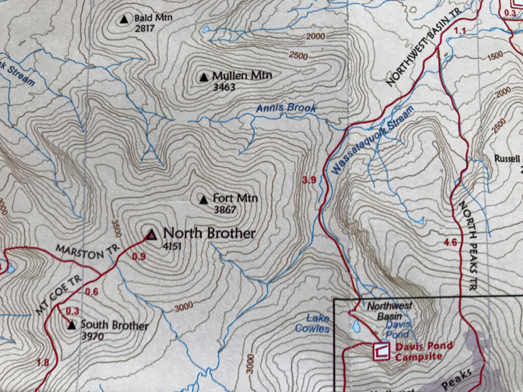
Contour lines show the lay of the land around North Brother Mountain. Carey Kish photo
Locate “D” on the map’s left margin and “3” on the bottom. From “D,” trace a line to the right, while from “3,” trace a line up the map. Near where these imaginary lines intersect, you’ll see North Brother Mountain (4,151 feet). Where the contour lines form concentric circles like this, that’s a summit. There’s another series of concentric circles just to the northeast; that’s the top of Fort Mountain (3,867 feet). The dip between shown as a level area is a saddle.
From the peak of Fort moving north toward Mullen Mountain, notice how the contour lines form an inverted V and then are U-shaped; this signifies a “ridge,” which leads to a saddle and the upper drainage of Annis Brook. Which way does the brook flow? The sharp end of the V-shaped drainage contours (always) points uphill, so the brook here flows east (to the right) downhill.
Southeast of North Brother is Davis Pond in the Northwest Basin. Those tightly spaced contour lines hemming in the pond depict cliffs.
What’s the distance between the peaks of North Brother and Fort? Using the map’s scale, I’d estimate a little over 1-1/4 miles.
Congratulations! You’ve just passed a rudimentary “Map Reading 101” course. I’ll cover basic compass use in a future column.
Carey Kish of Mt. Desert Island is the author of AMC’s Best Day Hikes Along the Maine Coast and editor of the AMC Maine Mountain Guide. Follow Carey’s adventures on Facebook @ Carey Kish.
Copy the Story LinkComments are not available on this story.
Send questions/comments to the editors.
