

Scattered thunderstorms are expected in Maine this afternoon. With plenty of energy to use, storms are expected to be strong, especially where clouds break apart and sunshine filters in.
The biggest threats associated with these storms are heavy rain and strong wind gusts. Underneath the strongest storm, hail is also expected.
While the overall threat for a brief spin-up is low, conditions suggest that it cannot be completely ruled out. Still, this is not the biggest concern moving forward. Straight-line wind gusts can be just as or more damaging than a weak tornado.
METEOROLOGY AND TIMING
I suppose we can’t talk about a storm threat without talking about why they happen.
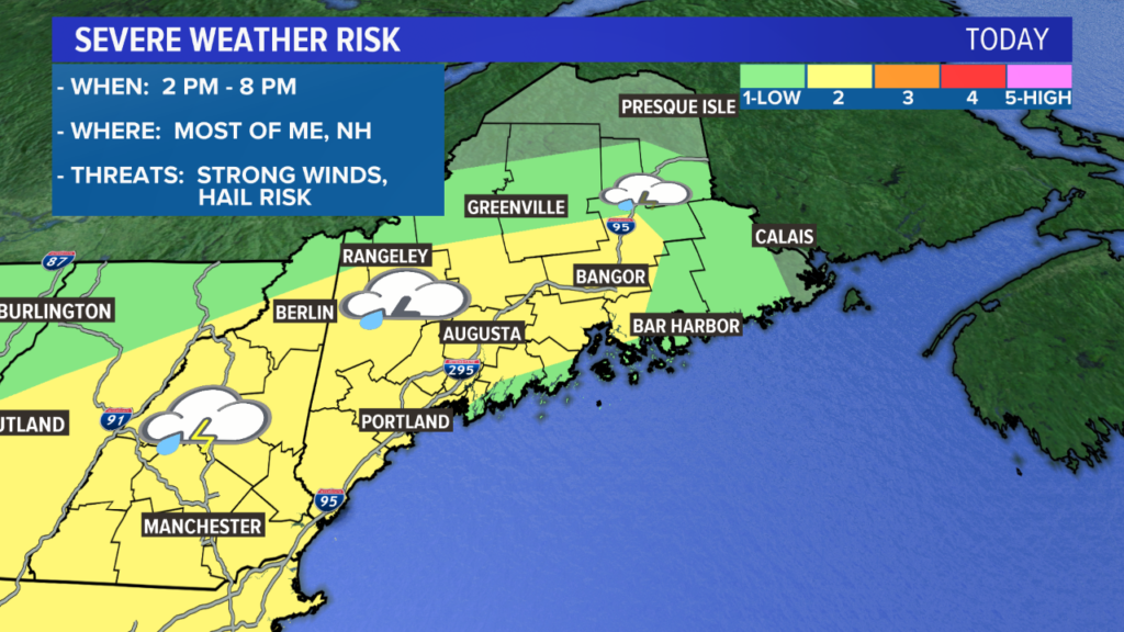
The best chance for severe storms is in the area highlighted in yellow. NEWS CENTER Maine
This outlook from the Storm Prediction Center highlights the areas most likely to see strong thunderstorms this afternoon. Areas in yellow have the best chance at seeing severe storms. Portland, Bangor, Augusta, Lewiston, Rangeley and Waterville are included in this area.
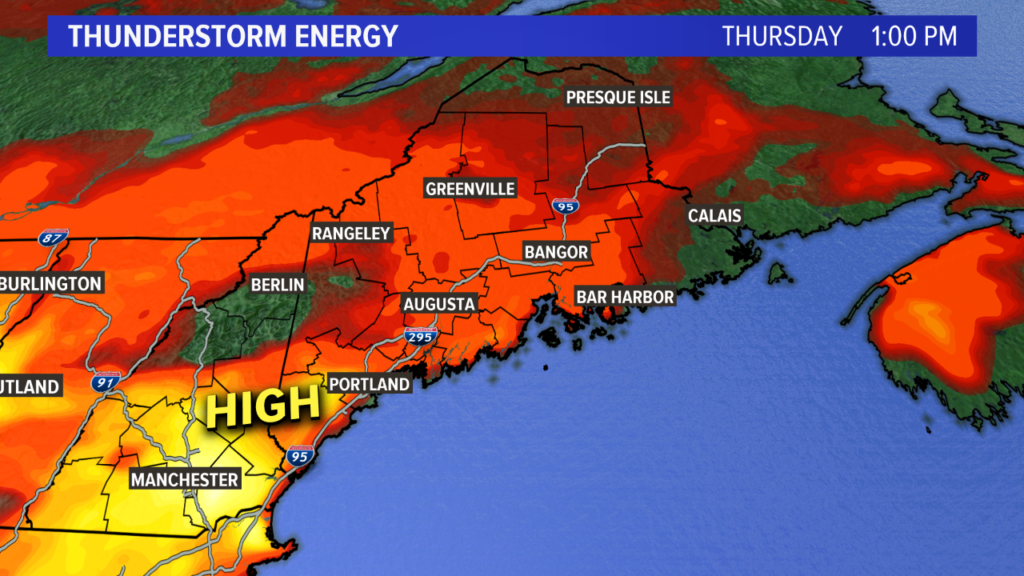
The most storm energy in the early to mid-afternoon will be in southern Maine. NEWS CENTER Maine
The image above shows thunderstorm energy. Orange and yellow mean that there is more energy available for thunderstorms to use, while red means there is less.
The more energy available, the stronger the storm can become.
Storm energy over southern Maine will peak in the early to mid-afternoon, which is when the first round of storms pushes through.
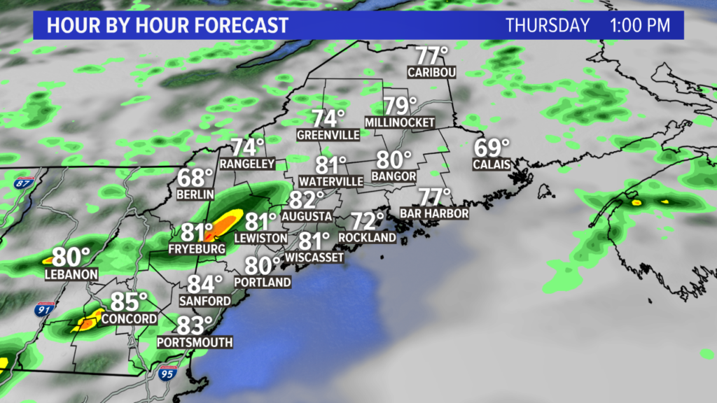
The first round of storms will be focused on southern Oxford, York and Cumberland counties. Some storms could push a bit closer to Lewiston or Augusta. NEWS CENTER Maine
Storms will form in New Hampshire. The motion will be to the southeast, eventually moving into Maine.

These storms move off of the coastline around 3 p.m. or 4 p.m. NEWS CENTER Maine
Since the environment will have plenty of energy to support strong to severe storms, these will need to be monitored closely. I also think this is where and when we have the best chance at seeing a brief spin-up.
While things ramp up across southern Maine, it will be a bit quieter closer to Bangor. However, this changes later in the afternoon.
Peak storm energy is expected in central Maine close to 5 p.m. or 6 p.m., so the storms are going to move in a bit later.

The late round of storms will be located through the highlands, eventually moving south. NEWS CENTER Maine
Again, the threats will be similar, though in the evening. This is important since storms will be crossing the Interstate 95 corridor in the middle of rush hour. Torrential rain under thunderstorms reduces visibility and also can cause hydroplaning.
The other severe threats are similar, though the likelihood of a brief spin-up is not much of a concern with this second set of storms.
Overall, storms will clear late in the evening with quieter conditions overnight.
THE THREATS
Storms are in an environment where they can easily tap into ample energy. There is also enough wind shear to keep them organized, which contributes to the severe weather threat today.
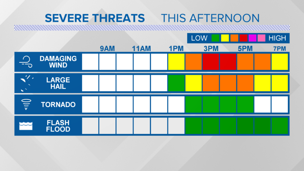
Watch for strong wind gusts and hail under thunderstorms. NEWS CENTER Maine
Under any storms, torrential rain is expected. There could be some isolated flash flooding in areas of poor drainage with such heavy rain.
Strong wind gusts are also expected under stronger storms. Isolated electrical outages will be possible as the storms move through.
Hail is a threat today, too. With enough cold air in the higher parts of the atmosphere, strong storms will support the best chances for hail to form. While it seems likely there will be at least some hail reported today, the biggest threat is still strong wind gusts.
Last, but certainly not least, is the threat for a brief spin-up. This is mostly for areas close to Sebago Lake, where we tend to see stronger storms.
The surface winds suggest there could be some extra rotation here. As such, storms will need to be monitored closely to see if a brief spin-up does occur. The threat overall is quite low, but it is not zero.
If you find yourself under a severe thunderstorm warning, seek shelter immediately. The best places to go are basements. If you do not have a basement, an interior room with no windows is also a good option.
You can use pillows or a helmet to try to protect your head in cases of severe storms, too.
Be sure to use caution and keep an eye to the sky this afternoon. Make sure you have multiple ways to get warnings in case you lose power.
Send questions/comments to the editors.

Success. Please wait for the page to reload. If the page does not reload within 5 seconds, please refresh the page.
Enter your email and password to access comments.
Hi, to comment on stories you must . This profile is in addition to your subscription and website login.
Already have a commenting profile? .
Invalid username/password.
Please check your email to confirm and complete your registration.
Only subscribers are eligible to post comments. Please subscribe or login first for digital access. Here’s why.
Use the form below to reset your password. When you've submitted your account email, we will send an email with a reset code.