

Exceptionally hot temperatures are baking parts of the West, bringing hazardous conditions to many and contributing to wildfires. The sizzling heat is worsening what’s already been the hottest summer on record for some, while fostering explosive wildfire growth in California. The unbearable temperatures come amid a Southwest monsoon that never got started, leaving much of Arizona and New Mexico especially parched.
Phoenix, a city used to heat, has been downright unbearable this summer. It’s been the city’s hottest summer to date on record, and an excessive heat warning remains in effect through Monday evening, with temperatures unlikely to fall much below 90 for the foreseeable future. Afternoon highs each day have hovered in the 110s, with only 0.1 inches of rain since June 15.
The National Weather Service described the city’s lack of monsoon rainfall as “pitiful.”
In California, residents are bracing for a potentially lengthy heat wave that will become established by this weekend. Forecasts have prompted excessive heat watches and warnings stretching along the entire Golden State, while a subtle increase in humidity will make for atypically toasty nighttime temperatures, particularly in Southern California, that offer little respite from the heat. And that’s precisely where numerous wildfires are ongoing, including one – the Lake Fire – that grew to 10,000 acres in a matter of hours. As of Thursday morning, the fire was at 10,500 acres and 0 percent contained.
The spate of heat will even affect areas as far north as northern Oregon, while also bringing obscenely hot temperatures in the 120s to parts of Nevada.
Weather models are in agreement that a strong ridge of high pressure will build across the West this weekend, with a northward jaunt in the jet stream allowing heat to swell northward across the West Coast. The high pressure “heat dome” will become centered over the Great Basin of Nevada, with clockwise winds around it drawing desert air northward. A prolonged, exceptional period of heat is likely.
Some 50 million people are likely to see temperatures exceed 100 degrees over the next week as the heat swallows not only the West and Southwest, but portions of the southern Plains as well. Even Dallas is expected to endure highs above 100 into early next week.
In the Sacramento Valley of California, highs will range between 100 and 108 degrees, while even the ordinarily cooler foothills will peak in the upper 90s or lower 100s, according to the National Weather Service.
“Dangerously hot conditions with temperatures 110-125 (are) expected” in parts of northwest Arizona, southwest Nevada, and adjacent extreme southeastern California in the Mojave Desert. Death Valley, Calif., could climb into the upper 120s. If the site makes it above 125 degrees, it would be the hottest temperature observed at that location this late in the year.
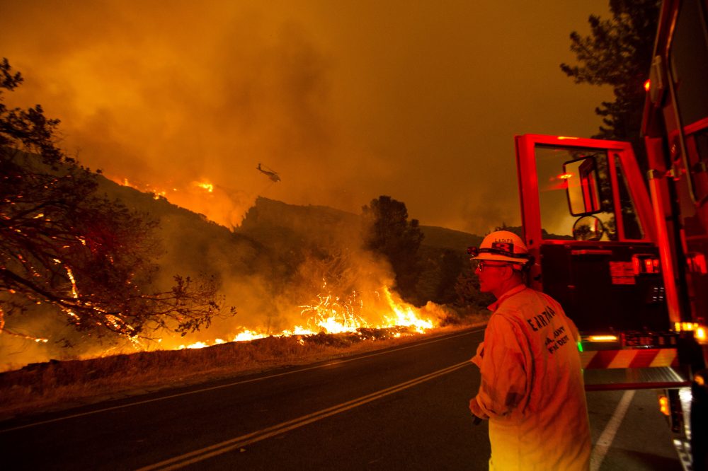
A firefighter watches as a helicopter drops water on the Lake Hughes fire in Angeles National Forest on Wednesday, north of Santa Clarita, Calif. Ringo H.W. Chiu/Associated Press
Las Vegas could see a streak of six or more days topping 110 degrees, the Weather Service warned.
Phoenix will peak in the 110s during much of the upcoming week, a degree or two higher than temperatures forecast in Las Vegas. Anaheim, Calif., will be in the lower to mid-90s, while places in California’s Central Valley, like Bakersfield and Fresno, could range between 105 and 110 degrees.
An excessive heat watch even stretches as far north as the Oregon-Washington border, where temperatures as high as 102 degrees are possible over the weekend. Portland could hit the century mark on Sunday.
Remnant moisture from what was once Category 2 Hurricane Elida over the eastern Pacific will stream northward, helping to keep overnight temperatures elevated, while refusing to yield any appreciable rainfall.
The heat looks to stick around through at least the next two weeks but could even linger into September, albeit in a tempered state.
It’s already been a memorable summer for heat in the Desert Southwest. Phoenix, in addition to logging its hottest summer to date on record, has broken the record for the greatest number of calendar days in a year to hit 110 degrees. The previous record was 33 days in 2011, but already through Wednesday, three dozen such days have been tallied. Records in Phoenix date back to 1895.
Arizona’s climate is warming thanks primarily to human-caused climate change, which has made days hitting 110 degrees in Phoenix twice as likely to occur nowadays compared to the 1950s. Climate change is known to boost the odds of as well as increase the severity and duration of heat waves. In sprawling cities like Phoenix, the effects of climate change are further amplified by the urban heat island effect, which keeps the city warmer than surrounding rural areas.
The city saw a record number of days in July that failed to drop below 90 degrees, a serious concern for vulnerable populations who count on nightfall as a reprieve from the daylight hours’ hostile temperatures. Before 1970, temperatures remaining above 90 all night long were virtually unheard of.
A contributing factor to heat over Arizona has been a reduction in cloud cover and thunderstorm activity during July and August as compared to average years. Ordinarily, the Southwest Monsoon – a seasonal wind shift that brings about increased moisture and thunderstorm activity – kicks in during the first or second week of July. Thanks to the monsoon, some places in Arizona see half of their annual rainfall in only a couple of months.
This year, however, the monsoon has been all but a no-show. Phoenix has only seen 0.1 inches of rain from it, and the metro area has recorded fewer than 300 lightning strikes. Several thousand would normally have been recorded at this point in the season.
In most years, temperatures peak in late June or very early July and start to slowly ease back as the air becomes more humid in August. That hasn’t been the case this year, and since dry air heats up more easily, Phoenix is continuing to bake.
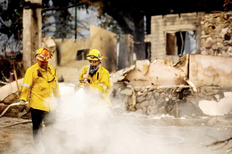
Late summer and particularly the fall are peak wildfire periods in California, when the warm season heat remains at full blast while the arid landscape awaits the eventual arrival of cool-season rains. The latest bout of heat settling into California and parts of the West will only exacerbate the fire threat, with hot temperatures further drying vegetation and leaving the landscape ripe with vegetation primed for burning.
The Lake Fire erupted Wednesday afternoon in the Angeles National Forest in northern Los Angeles County. By Thursday morning, it was at 10,500 acres and zero percent containment after growing substantially Wednesday evening.
On Wednesday night, the Los Angeles County Sheriff’s Department warned of “extreme fire behavior,” while videos posted on social media captured the uncontrolled blaze spinning up fire whirls beneath a rotating smoke plume. Evacuations were ordered as the fire began to threaten homes.
The Red Cross in Los Angeles established a temporary evacuation point at Highland High School in Palmdale for residents forced to flee but declined to open a shelter. Instead, the organization instructed residents to “stay in their cars” in the face of the coronavirus pandemic, a response some questioned on social media.
The Red Cross is not accepting donated items due to coronavirus safety concerns.
The valley just to the east of the fire en route to Palmdale is forecast to hit 108 degrees on Saturday, with breezy conditions at night complicating firefighting efforts. Conditions are unlikely to improve in the forecastable future.
Climate change is having a serious effect on wildfire activity in the West and Southwest. The Fourth National Climate Assessment warned that climate change had already increased the size of areas burned by wildfires by drying out forests and boosting the availability of wildfire fuel.
The report estimates that the area burned by wildfires in the past decade is twice what it otherwise would have been without climate change, painting a grim picture of the region’s future.
Comments are not available on this story.
Send questions/comments to the editors.
