


WESTBROOK — State and local officials tested the ground next to the Presumpscot River in Westbrook on Thursday to make sure the bank stabilized after a large landslide blocked the river on Wednesday, triggering a flash flood watch.
More assessments will take place Friday before officials determine whether the area is safe for engineers and work crews to begin shoring up the riverbank and restoring the river’s flow.
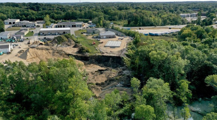
An area estimated to be 300 feet by 300 feet – the equivalent of two football fields or 2 acres – collapsed and slid into the river Wednesday morning, taking with it trees and soil. A smaller slide occurred Wednesday afternoon. The initial landslide blocked the river temporarily, and the water level behind the blockage quickly rose about 13 feet.
The rising water behind the landslide raised concerns that the river would break through the blockage and send a surge of water downstream.
Sappi North America restricted the river flow at its five dams just upstream to reduce the risk of flooding and enough water naturally found its way through and around the obstruction so that the river fell to a level of 8 feet, or about 7 feet above where it was before the landslide, city officials said Thursday.
Because the water level was unusually low before the slide, it never overflowed the riverbanks or caused upstream flooding. And officials said the immediate risk of flash flooding had passed by Thursday afternoon.
“We do not anticipate any issue whatsoever with flooding,” Fire Chief Andrew Turcotte said Thursday afternoon.
Officials remained concerned Thursday about sediment and trees getting pushed downriver and possibly damaging water mains that cross the river just downstream.

National Oceanic and Atmospheric Administration
Engineers took core samples of the soil to gauge the stability of the riverbank in the area where the landslide occurred. Once they determine it is safe, officials plan to bring in equipment to further stabilize the area for restoration work.
It’s unclear how soon work can begin to restore the river flow and what steps will be taken to reduce the damage. Turcotte said drones will be used Friday to further measure and assess the landslide. He also said it is possible a channel could be created to increase the river’s flow.

Westbrook Mayor Michael Foley addresses the media Thursday. He declared a state of emergency in the city Wednesday after the landslide. Brianna Soukup/Staff Photographer
“Time is on our side as we assess the situation,” Mayor Michael Foley said, noting there is no rain in the forecast for the immediate future.
The landslide was reported Wednesday morning after people saw trees moving on the river’s forested bank. The landslide, which happened directly behind Les Wilson & Sons excavators at 161 Warren Ave., also took a large area of soil and a pile of fill.
Approximately 90 yards of sand and salt mixture and a salt shed also were swept away but rested on the bank and did not reach the river. Turcotte said there are no issues with water quality as a result of the landslide.
The landslide was so large it initially blocked the river just downstream from the Sappi mill. It prompted the National Weather Service to issue a flash-flood watch and the mayor to declare a state of emergency in the city. Crews spent Wednesday assessing the potential flood impact and the threat the landslide posed to a nearby 60-inch water main and a 16-inch gas main.
Michelle Clements, a spokesperson for the Portland Water District, said Thursday that the water district is concerned about a 60-inch transmission line, two 42-inch water mains that cross the river downstream and a wastewater outflow downstream.
Water district staff have been in close contact with public safety and incident responders to monitor the event, Clements said. The infrastructure has been inspected and found to be unharmed.
“Our main concern is the possibility of a heavy release of water that could wash out water mains. We have taken actions to reduce the impact of such an event and protect the water supply, mainly ensuring adequate water storage and partially closed valves to reduce the flow through the river-crossing mains,” Clements said in an email. “This also ensures a quicker shut down should we need it. We are also concerned about the possibility of heavy debris obstructing the wastewater outflow.”
The landslide happened across the river from the site of the state’s largest landslide, which occurred in 1868, when about 20 acres shifted, eventually covering about 38 acres with displaced soil, according to materials published by the Maine Geological Survey.
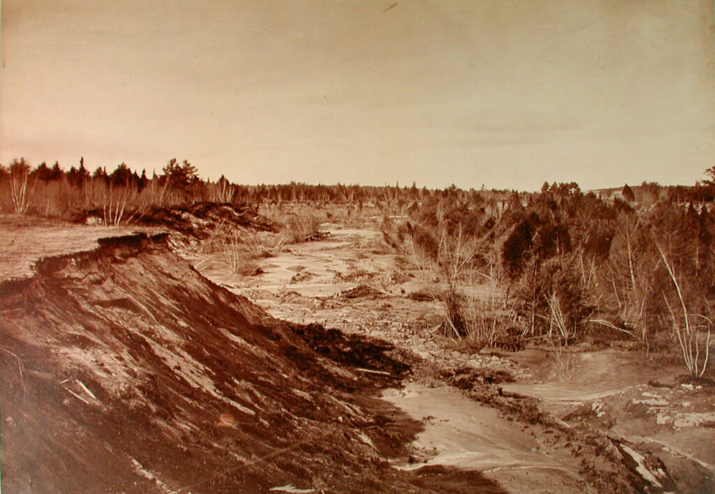
A chasm was formed by a landslide at Cumberland Mills in 1868. Collections of Maine Historical Society, courtesy of MaineMemory.net, item #10782
A geologic investigation of the area in 1990 found that a layer of soft clay lies beneath the area and extends deep underground. The softness of the clay means that the material behaves like a viscous fluid that can “flow” rather than break into discrete pieces.

Lindsay Spigel, senior geologist for the Maine Geological Survey, cited the soft clay layer called the Presumpscot Formation as the cause of the landslide but couldn’t say for sure what triggered its movement. Brianna Soukup/Staff Photographer
This layer is referred to as the Presumpscot Formation, and a later 2008 geological survey found that the formation surrounds the river outside of its immediate banks.
Lindsay Spigel, senior geologist at the Maine Geological Survey and landslide expert, said she has visited the site but didn’t get too close because the nearby land was still unstable. She cited the Presumpscot Formation as the cause of Wednesday’s landslide but couldn’t say for sure what triggered it.
Spigel said it could have been the weight of the fill on top of that clay layer, the shaking of heavy equipment or a fluke. She said it is an unusual time of year for landslides, which usually happen in spring when the ground is wet.
However, there have been hundreds of landslides in southern Maine since the end of the last ice age, including several along the Presumpscot River, she said.
“These have been happening for thousands of years. Every so often we get a reminder of their existence,” Spigel said.
Chris Wilson, owner of Les Wilson & Sons, an excavating contractor, said the slide began around 9 or 9:30 a.m. and consumed piles of aggregate he was keeping on his lot. The sliding earth eventually consumed one pile of dirt and half of a second pile, and dragged a metal salt shed and some equipment with it.
Cracks in the earth were visible Wednesday in Wilson’s equipment yard near the edge of the slide. He dismissed the idea that his company’s piles of fill and aggregate and the daily operations of heavy equipment might have contributed to the unstable soil conditions.
Spigel said the tests that will be done in the area of the landslide will help determine if it is safe for the excavating company to resume its activity in the area.
The city stopped work at a nearby construction site while it waits for more information from test results.
Foley on Thursday asked people to continue to stay away from the landslide, which is unstable and hard to reach. As crews were onsite Wednesday, a small area near the landslide collapsed and trees continued to fall, he said.
Some of the riverbank that was swept into the river has formed an island with trees that are still standing, as if they had grown in the middle of the river. Foley said those are expected to fall as their roots give way to water flowing through them.
The state of emergency remains in effect and could be extended by the City Council to allow the city to access the resources it needs to address the landslide, Foley said. The council has scheduled an emergency meeting for Monday.
Send questions/comments to the editors.

Success. Please wait for the page to reload. If the page does not reload within 5 seconds, please refresh the page.
Enter your email and password to access comments.
Hi, to comment on stories you must . This profile is in addition to your subscription and website login.
Already have a commenting profile? .
Invalid username/password.
Please check your email to confirm and complete your registration.
Only subscribers are eligible to post comments. Please subscribe or login first for digital access. Here’s why.
Use the form below to reset your password. When you've submitted your account email, we will send an email with a reset code.