


It took years of effort and investment to bring migratory fish back to the Presumpscot River as it flows through Westbrook. Now experts and advocates will have to wait to see what impact a landslide that blocked the river this week has on fish migration patterns and the river’s health.
Sea-run fish won’t migrate upriver until spring, and advocates hope that will allow enough time to restore the river and allow clear passage. And the impact on the health of other aquatic live could depend on how much of the sediment is removed and how much is left to blanket the riverbed downstream.
Federal engineers will arrive Saturday to help determine whether the riverbank has stabilized and what happens next. City officials say they do not yet have a clear timeline for assessing landslide damage and making plans to shore up the riverbank and restore the river’s flow.
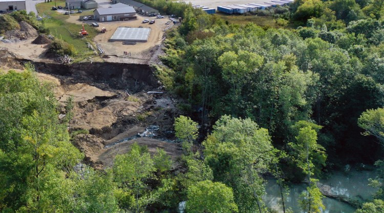
An area estimated at 300 feet by 300 feet – the equivalent of two football fields or 2 acres – collapsed and slid into the river Wednesday morning, taking with it trees and soil. The landslide, which happened directly behind Les Wilson & Sons excavators at 161 Warren Ave., also took a large area of soil, a pile of fill, a salt shed and it damaged construction equipment.
The landslide happened across the river from the site of the state’s largest landslide, which occurred in 1868. About 20 acres shifted in that slide, eventually covering about 38 acres with displaced soil, according to materials published by the Maine Geological Survey.
A geologic investigation of the area in 1990 found that a layer of soft clay – known as the Presumpscot Formation – lies beneath the area and extends deep underground. The softness of the clay means that the material behaves like a viscous fluid that can “flow” rather than break into discrete pieces.
A landslide expert with the Maine Geological Survey said this week’s landslide was caused by the Presumpscot Formation, but it’s too soon to tell what triggered it.
The landslide blocked the river temporarily, and the water level behind the blockage quickly rose about 13 feet. The rising water behind the landslide raised concerns that the river might break through the blockage and send a surge of water downstream, but officials now say there is no threat of flooding.
“With the dry conditions we’ve had, they’re able to manage a lot more water with the dams than they would during normal wet conditions. Time is on our side with this situation,” Mayor Michael Foley said Friday.
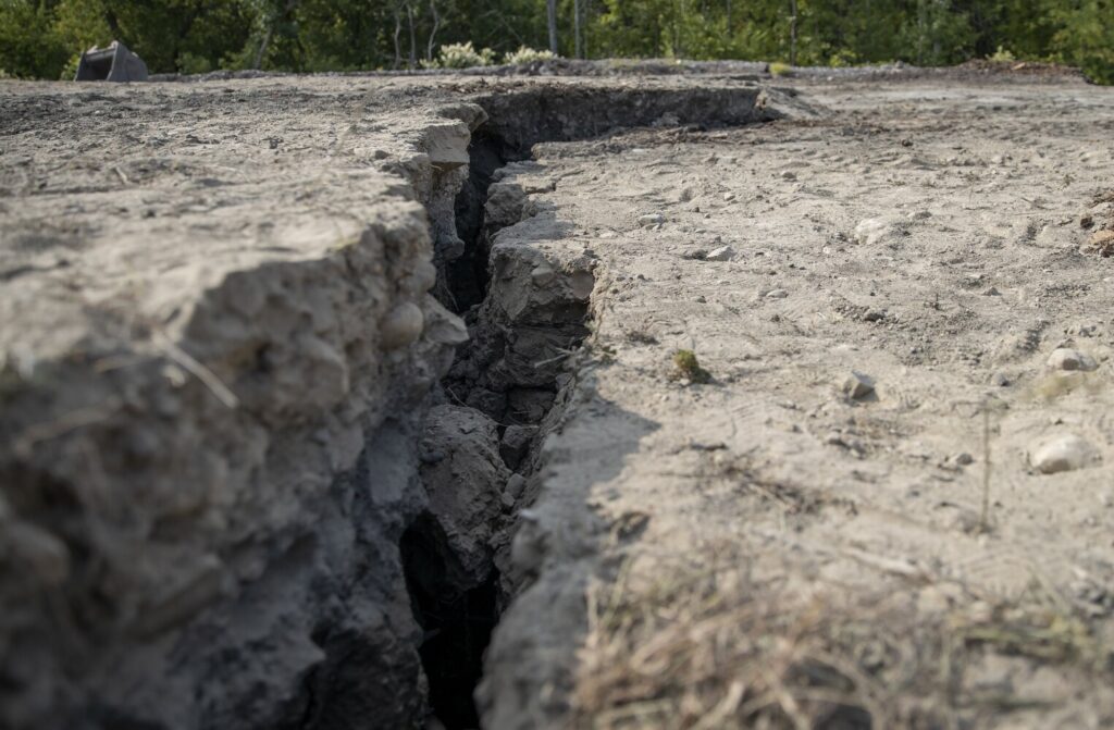
Deep fissures are left in the ground after a landslide occurred at 161 Warren Ave. in Westbrook on Wednesday. Derek Davis/Staff Photographer
Officials remain concerned about sediment and trees getting pushed downriver and possibly damaging water mains that cross it just downstream. A gas main that crosses the river has been shut off and so far there are no signs of issues with the water mains.
The river is now flowing through and around the obstruction, although the water level behind the landslide Friday remained about 7 feet higher than it was before it was blocked. Water remained muddy even miles downriver Friday.
David Madore, a spokesman for the Maine Department of Environmental Protection, said DEP staff has been on site this week and is working closely with other agencies to respond to the landslide. However, because of safety issues in the area, it will be some time before staff is able to assess the environmental impact, he said.
Fire Chief Andrew Turcotte said this week there is no immediate concern with water quality related to a pile of salt-and-sand mixture that shifted during the slide because it did not make it into the river. Material from industrial land that did slide into the river was described as clean fill.
Still, river advocates are keeping a close eye on the potential impacts on the Presumpscot. Foley says he also is concerned about the potential longterm environmental impact of the slide, particularly on migratory fish.
Groups such as Friends of the Presumpscot River and the Conservation Law Foundation have been working for decades to remove or bypass 10 dams that block upstream passage for sea-run fish such as river herring, American shad and Atlantic salmon.
Sappi North America last year began removing a dam at Upper Saccarappa Falls, a move that was welcomed by advocates as part of a multistage project that aims to restore fish passage and wildlife habitat in the Presumpscot. The dam lies upriver from the site of the landslide.
“The progress at Saccarappa Falls has been great,” said Sean Mahoney, executive vice president of the Conservation Law Foundation. “It’s too bad that this had to happen at the same time that we had such progress being made at Saccarappa.”
Depending on what sort of changes there are to the river and its morphology, there could be changes in the migration patterns of alewives, blueback herring and shad that would be coming up the river next spring, Mahoney said.
Michael Shaughnessy of the Friends of the Presumpscot River believes that the response to the landslide has been handled well. But he said the friends group is concerned about water quality and fisheries access.
Right now, some fish are traveling downriver, an easier process than in spring when they migrate upriver.
“We want to make sure the fish will be able to get up there. If it’s flowing, the fish (migrating back to the ocean) are going to find it and go down. Nothing is going to stop the river,” said Shaughnessy, who is also a city councilor. “We’re more concerned about upriver migration that would start to happen in May of next year.”
Theo Willis, environmental science professor at the University of Southern Maine, said juvenile alewives tend to migrate back down the river in October, but that the biggest populations have spent the summer downriver from the landslide.
And, he said, whether the sediment alters the health of the river ecosystem depends in part on how much of it can be removed.
“It ultimately, I think, depends on what happens to that slug of mud that’s in the river,” he said. “If you carpet the bottom with mud, that does have the potential to have a negative impact on things that live on the bottom,” he said. “It really depends on whether they take it out or let it wash downstream.”
The sediment that is now turning the river brown may not have a long-term impact. But, he said, “fishing might not be very good down there for the foreseeable future until the water clears up.”
Beyond the potential environmental impacts, Shaughnessy said, the landslide could make city officials look at soil stability differently as they consider development projects in the city. A construction project near the landslide site has been halted by the city while engineers determine if the area is stable.
“We’re becoming more aware now that the stability of land can be an issue for some things that happen on that land,” Shaughnessy said.
The presence of the unstable Presumpscot Formation clay has been well known, but the land around the river has not been studied to determine where it could be unstable.
Foley, the mayor, said assessments of the landslide site will continue over the weekend with the U.S. Army Corps of Engineers. Nearby private property owners are also having geo-technical assessments done, he said.
City officials may have more information by next week about the next steps for dealing with the landslide, Foley said.
“I’ve equated it to the coronavirus,” he said. “It happened so fast to begin with. It really takes a long time to unwind it.”
Copy the Story LinkSend questions/comments to the editors.

Success. Please wait for the page to reload. If the page does not reload within 5 seconds, please refresh the page.
Enter your email and password to access comments.
Hi, to comment on stories you must . This profile is in addition to your subscription and website login.
Already have a commenting profile? .
Invalid username/password.
Please check your email to confirm and complete your registration.
Only subscribers are eligible to post comments. Please subscribe or login first for digital access. Here’s why.
Use the form below to reset your password. When you've submitted your account email, we will send an email with a reset code.