

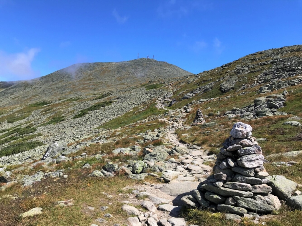
The summit of New Hampshire’s Mt. Washington, as seen along the Crawford Path on the Appalachian Trail. Carey Kish photo
There are hiking challenges aplenty in the northeastern U.S., more than enough checklists to keep goal-oriented hikers busy for a lifetime. The 4,000-footers of Maine, New Hampshire and Vermont – 67 summits in all – is probably the best known to Mainers. Add the 46 4,000-footers in New York’s Adirondacks plus two in the Catskills and you’ve got the Northeast 115.
The New England 100 Highest – all of the region’s 4,000-foot peaks and then some – is another premier challenge. There’s the 52 With a View and the Terrifying 25 in New Hampshire. You can also try hiking every trail (known as “redlining”) in the AMC White Mountain Guide or Maine Mountain Guide. The lists go on and on.
One worthy pursuit that doesn’t get much play among the hiking list makers is the New England State High Points, which ranges from lofty Mt. Washington to a wooded hill in Rhode Island. This highly rewarding endeavor not only nets you miles of good hiking, but gets you out and about exploring more of the beautiful six-state area.
Unless you’re an experienced winter hiker, it’s getting late in the season for tackling the New England State High Points, especially the northernmost three (Katahdin trailheads are actually closed until Dec. 1). No worries, though, as you have plenty of time over the winter to do some research and work out the logistics for this great adventure in the nice weather of next summer. Here’s some info on recommended routes to get you started.
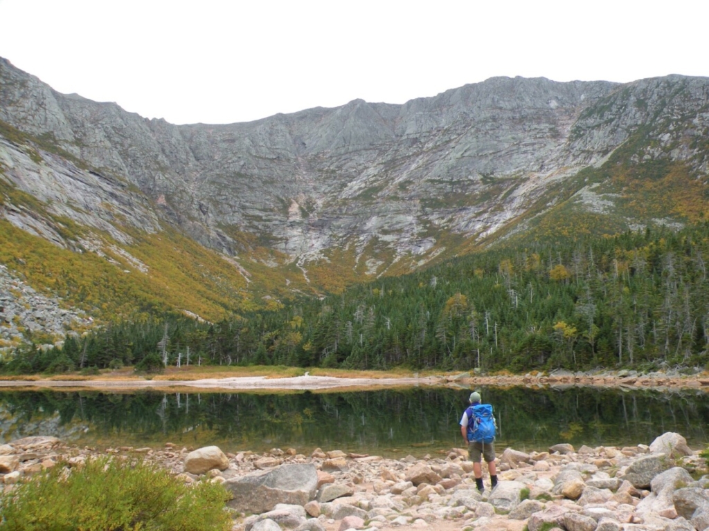
The high walls of Great Basin, including Knife Edge and Baxter Peak from Chimney Pond, at Katahdin. Carey Kish photo
MAINE: KATAHDIN
The newly rerouted Dudley Trail reopened this fall, as good a reason as any to climb Katahdin. From Roaring Brook Campground, hike the Chimney Pond Trail to the namesake pond, then ascend the Dudley Trail past Index Rock to the peak of Pamola. Ahead, tackle the airy and exciting Knife Edge to reach Baxter Peak at 5,268 feet and the best mountain vista in the state. Descend via the Saddle and Chimney Pond trails. At 11 1/2 miles, it’s a big day.
NEW HAMPSHIRE: MT. WASHINGTON
With a cog railway, auto road, summit buildings and dozens of trails, the rooftop of New England can be a crowded place. Nevertheless, outstanding views and extraordinary Alpine terrain make Mt. Washington a highly prized objective. From the Marshfield Station trailhead, take the Ammonoosuc Ravine Trail to the AMC Lakes of the Clouds Hut. The Crawford Path, which is part of the Appalachian Trail, then leads to the 6,288-foot summit. Descend via the Gulfside and Jewell trails for a 9 1/2-mile circuit.
VERMONT: MT. MANSFIELD
The top of Vermont features a grand panorama ranging up and down the Green Mountains, east to the White Mountains, and west to Lake Champlain and the high peaks of the Adirondacks. Climb Mansfield from the west at Underhill State Park via the CCC Road and Maple Ridge Trail. Break out of the trees at the Forehead, then follow the Long Trail along the high open ridgeline all the way to the Chin at 4,043 feet. Return via the Sunset Ridge Trail for an 8-mile loop.
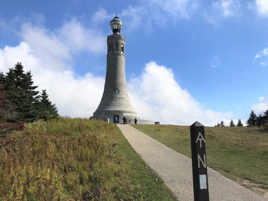
The summit of Mt. Greylock in Massachusetts is topped with a 92-foot granite war memorial tower. Carey Kish photo
MASSACHUSETTS: MT. GREYLOCK
The 3,491-foot summit of Mt. Greylock, capped by a 92-foot granite war memorial, offers fine views over the northern Berkshires into Vermont’s Green Mountains and New York’s Taconic Range. Start from the west at the Hopper Road trailhead. Combine the Haley Farm Trail over Stony Ledge and the Hopper and Appalachian trails to gain the peak. Finish via the Hopper and Money Brook trails for a 9-mile lollipop loop.
CONNECTICUT: MT. FRISSELL
Connecticut’s high point is located at 2,380 feet on the south shoulder of Mt. Frissell, while the mountain’s actual 2,454-foot summit is just north over the Massachusetts state line. From the east at the Mt. Washington Road, hike the Mt. Frissell Trail over Round Mountain to Frissell and the high point. Continue west past the Tri-State marker, then take the South Taconic Trail to the top of Mt. Brace (2,311 feet) for fabulous 360-degree views. About 5 miles round-trip.
RHODE ISLAND: JERIMOTH HILL
From Route 101 in Foster in the northwest corner of the state, it’s a quarter-mile walk to wooded Jerimoth Hill and the rocky outcrop at 812 feet that marks Rhode Island’s apex. Once difficult, if not illegal, to reach because of access issues, the state of Rhode Island now owns the property.
Carey Kish of Mount Desert Island is the author of AMC’s Best Day Hikes Along the Maine Coast and editor of the AMC Maine Mountain Guide. Follow Carey’s adventures on Facebook @CareyKish
Send questions/comments to the editors.

Success. Please wait for the page to reload. If the page does not reload within 5 seconds, please refresh the page.
Enter your email and password to access comments.
Hi, to comment on stories you must . This profile is in addition to your subscription and website login.
Already have a commenting profile? .
Invalid username/password.
Please check your email to confirm and complete your registration.
Only subscribers are eligible to post comments. Please subscribe or login first for digital access. Here’s why.
Use the form below to reset your password. When you've submitted your account email, we will send an email with a reset code.