


John Dever of Bath couldn’t help notice that the world sort of shrunk last year.
In May 2020, his family was scheduled to make its yearly trip to Quebec City, in Canada, probably the last one before the eldest of his two sons went off to college. His son, Griffin, was also scheduled that year to take a school trip to Eastern and Central Europe – which cost about $2,500 – and had worked hard to save the money. Both trips were canceled because of the pandemic.
So when Dever, a social studies teacher at Morse High School, read that the Osher Map Library and Smith Center for Cartographic Education in Portland was collecting stories for an exhibit on the havoc COVID-19 wreaked on travel plans, he emailed a description of his family’s plight. His story ended up inspiring one of the maps in the exhibit, “Where Will We Go From Here? Travel in the Age of COVID-19,” which is on display at the Osher Map Library at the University of Southern Maine now through Oct. 15.
“I know it’s nothing compared to the suffering so many people endured, but to have the world forcibly shrunken like this was difficult,” said Dever, 55. “As parents, we’ve always thought it’s important for our boys to travel as part of their education, to get out and see the different ways people live.”
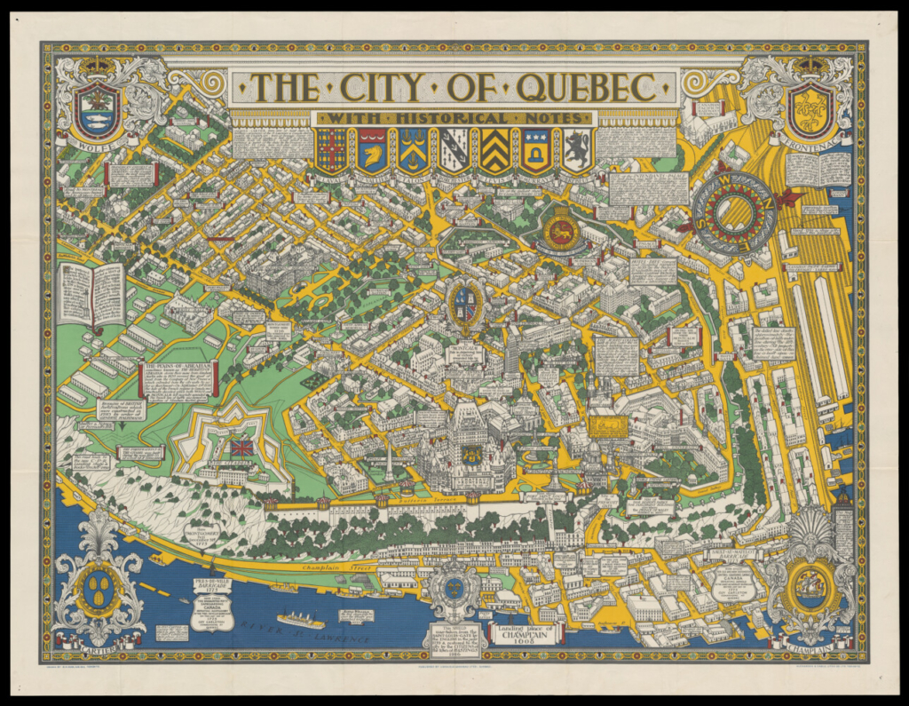
This map of Quebec City from 1932 was included in the Osher Map Library’s exhibit “Where Will We Go From Here? Travel in the Age of COVID-19” because of a Bath family who canceled plans for a last family trip there. Photo by Adinah Barnett
CONNECTING WITH HISTORY
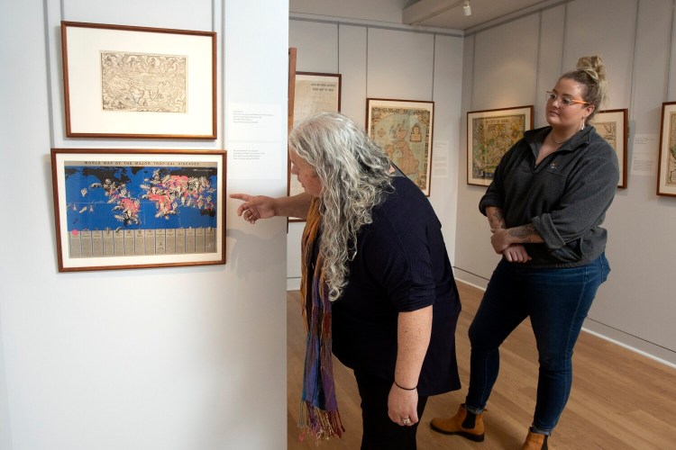
The exhibit, which opened in May, was an opportunity to use historic maps from the library’s collection to put a focus on a contemporary event, said Libby Bischof, the executive director of the map library. It was also an opportunity for the map library to put together its first crowd-sourced exhibit.
Library staff put out a call for stories from around Maine and beyond. More than 150 people shared the tales of their canceled travel plans and some 45 appear as text, next to historic maps of the places the stories were about. Some 60 maps and related cartographic items are in the exhibit.
The map on display next to Dever’s story is a pictorial view of Quebec City from 1932, in bright yellow, green. blue and red, with detailed notes on the city’s history. There’s an image of a shield with a French emblem and a note that the shield was taken by the invading English in 1759 and returned to the city in 1926. Other historic elements of the map include a marking on the spot where Champlain first landed in 1608 and a blurb about the Plains of Abraham, where a famous battle between the French and English was fought in 1759. While the name of the battle site sounds Biblical, the blurb says it was named for Abraham Martin, who was granted the land by France in 1635.
“As an historian, I wanted to find a way to mark this watershed moment and use our maps to reflect upon it,” said Bischof. “When people filled out the surveys and sent us their stories, they were processing their grief about these plans.”
The exhibit was curated by Bischof, along with Louis Miller, cartography reference and teaching librarian, and University of South Maine students Morgan Day and Teri Honeycutt.
People submitted their stories in January and February when COVID-19 case numbers were high, few people had been vaccinated and the future looked uncertain at best. So the stories reveal the emotional power of travel, how people feel a sense of loss when travel plans are canceled but can also remain optimistic about the possibility of traveling once again.
Dever, for instance, has made reservations for his family to go to Quebec City in August and just learned this week that Canada was opening its borders to vaccinated Americans. So he and his family would likely be able to make the trip.
The stories submitted, and the maps they inspired, are divided into different categories in the exhibit. One section deals with travel that was planned for birthdays, anniversaries or family reasons, while other areas focus on lost trips that had been scheduled for a wedding, work or studying abroad. The exhibit also has a fascinating section on maps that deal with public health and other disease outbreaks in the past.
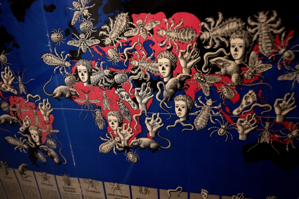
World map of tropical diseases in 1944, on exhibit now at the Osher Map Library as part of “Where Will We Go From Here? Travel in the Age of COVID-19.” Photo by Derek Davis/Staff Photographer
One of the most eye-catching examples in that latter category is a striking blue and pink “World Map of the Major Tropical Diseases” that was created by Russian-born artist Boris Artzybasheff and appeared in Life magazine in 1944, in the midst of World War II. With so many American soldiers and sailors serving in the Pacific, tropical diseases like malaria and yellow fever were hot topics. The map uses eerie images of rats, snakes and insects to denote the various diseases and where they’d been detected. Another map in this section shows the spread of cholera around the world in the early 1800s, a reminder that we’re hardly the first generation to confront a pandemic.
Another unique historic map depicting a different view of a contemporary travel destination is a 1945 map of Germany, showing how the nation was divided into zones controlled by Allied forces – English, Russian, American, French – after World War II. The map also shows Germany’s boundaries in 1938, before it occupied Austria and Czechoslovakia and, in 1939, before it invaded Poland. A note on the map says it is for use by “War and Navy Department agencies only, not for sale or distribution.” So it was most likely an educational tool for soldiers and sailors stationed in Germany after the war, Bischof said.
The map’s use in the exhibit was inspired by Anne Kelly Knowles, a University of Maine history professor and historical geographer who has been researching the Holocaust. Knowles’ research focuses on the places that were affected and destroyed by the Germans as they sought to exterminate the Jewish population across Europe. She had planned to go to Berlin in early 2021 to research at archives and then visit Holocaust sites in Eastern Europe, but had to postpone the trip because of the pandemic.
“Nothing is more meaningful to a geographer than seeing the place you are studying on the ground, in person – to study the landscape, feel the weather, walk the distances from here to there. I think of it every day,” wrote Knowles, in text that appears with the map.
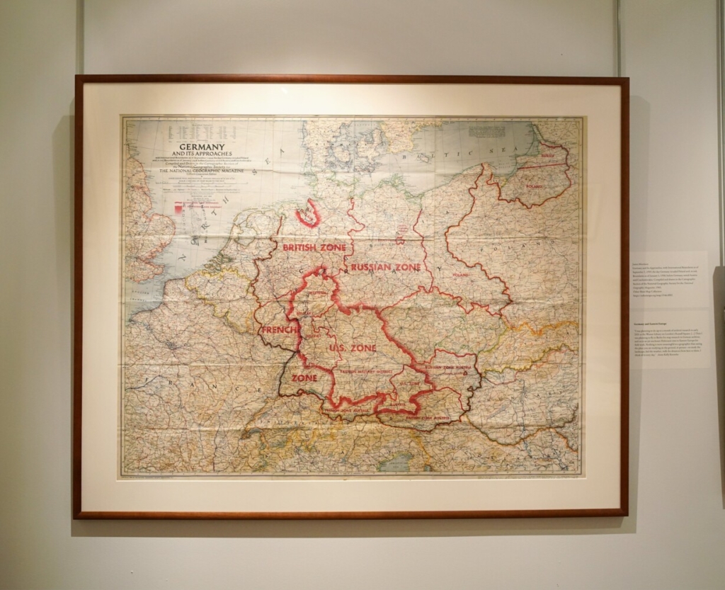
The exhibit includes a 1945 map of Germany under Allied control, with boundaries before World War II as well. Photo by Gregory Rec/Staff Photographer
Knowles said she has funding to reschedule the trip for next summer, if conditions allow. She is part of a larger effort by researchers around the world called the Holocaust Geographies Collaborative. She’s also working on an atlas of the Holocaust.
Another personal travel story that inspired a map in the exhibit came from John Taylor, an Indiana native who works at the Margaret Chase Smith Library in Skowhegan as the National History Day in Maine state coordinator and museum assistant. Taylor usually goes back to Indiana with his wife every May for what is probably that state’s most famous event – the Indianapolis 500 auto race. The 2020 competition would have been his 20th race, but the pandemic canceled it. The 2021 race was held, before a limited crowd, but Taylor did not feel comfortable going.
“Growing up outside of Indianapolis, it was a really big deal. The whole month of May has events people go to,” said Taylor, 40.
As someone who works in history, he appreciates the Osher Map Library’s attempt to connect little-seen maps and historic views of places with people’s travel plans.
“It’s a great way to highlight these pieces, some never or rarely seen, with all these stories about how people were affected by canceled travel plans,” said Taylor.
The exhibit also has a video monitor scrolling over people’s comments about how the pandemic has affected them, including canceled trips for work, to study or to see family. People who submitted stories answered a series of questions online, including where they will go first when they can travel again. Some listed the places they couldn’t go because of the pandemic, but not all did.
“Many said they just wanted to go hug their grandkids or see family,” said Bischof. “It was very personal.”
Send questions/comments to the editors.

Success. Please wait for the page to reload. If the page does not reload within 5 seconds, please refresh the page.
Enter your email and password to access comments.
Hi, to comment on stories you must . This profile is in addition to your subscription and website login.
Already have a commenting profile? .
Invalid username/password.
Please check your email to confirm and complete your registration.
Only subscribers are eligible to post comments. Please subscribe or login first for digital access. Here’s why.
Use the form below to reset your password. When you've submitted your account email, we will send an email with a reset code.