

New England hasn’t seen a direct strike from a hurricane since Category 2 Bob visited in 1991, but there’s a growing chance that lucky streak ends this weekend. Odds are climbing that Tropical Storm Henri, which spun offshore of Bermuda earlier this week, may ride parallel to the East Coast, sweeping northward and directly affecting the Northeast.
Computer models have become increasingly bullish on the potential of a close shave or direct hit to New England late Sunday into Monday. Mild waters off the coast could maintain Henri as a strong tropical storm or marginal hurricane, which could make it the first hurricane to make landfall in New England in more than three decades.
The National Hurricane Center wrote early Thursday that storm surge, wind and rain impacts in the northeastern U.S. are “a distinct possibility” due to the storm.
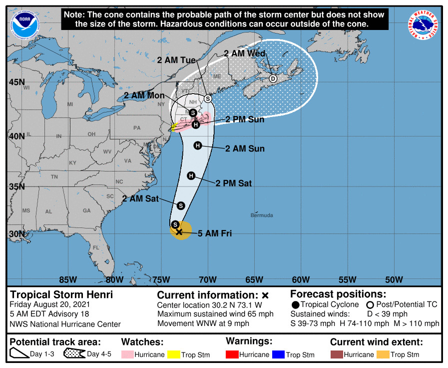
Henri was a 70 mph tropical storm as of 11 a.m. Eastern time on Thursday, but is primed to strengthen, and could become a hurricane over the next day or so.
It comes as the remnants of Fred continue to work through the northern Appalachians, while Grace, a borderline Category 1 hurricane, made landfall in the Yucatán Peninsula of Mexico south of Cancún.
If it seems like Henri suddenly entered the forecast equation late Wednesday, you’re not imagining things. Before that time, it was expected with relatively high confidence that Henri would drift out to sea. Then by midmorning Wednesday, computer models began portraying a potential scenario that would bring Henri closer to the coast – or even directly into Long Island, Rhode Island or Cape Cod.
By Wednesday night, the National Hurricane Center shifted their forecast “cone of uncertainty” 150 miles west to accommodate the worrisome trend.
“Right now, it is advisable to begin preparing for a possible landfalling storm in (Southern New England),” wrote the National Weather Service office serving the Boston region Thursday morning.
The Northeast is one of the most densely-populated swaths of real estate in the nation and in North America, making every tweak to the forecast a high-stakes one. The National Weather Service is launching additional weather balloons from 26 sites in the northern and eastern Lower 48 to try to improve computer modeling of Henri’s projected path.
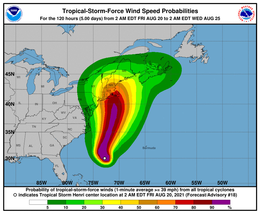
On Thursday morning, Henri was about 350 miles southwest of Bermuda, or roughly 1,300 miles south of Nantucket, Massachusetts, moving west at 9 mph. No watches or warnings have been issued for the U.S. mainland yet due to uncertainty in Henri’s path.
Satellite imagery Thursday morning revealed that Henri was struggling against wind shear, or a change in wind speed and/or direction with height. That was disproportionately blowing elements at the upper levels of the storm to the south-southwest and away from the center. Until that shear dwindles by Saturday night, Henri won’t have much of an opportunity to strengthen in any major way.
That said, the storm was exhibiting “convective bursts,” meaning thunderstorm activity was roiling. There is sufficient fuel to brew a meaty hurricane as soon as disruptive upper-level winds abate.
Henri will likely become a 90 mph hurricane by early Sunday as it rides north off the East Coast. That’s where atmospheric steering currents enter the equation. A dip in the jet stream carrying cool air at the upper levels, and reducing air pressure, will be positioned to the west, swinging over the Mid-Atlantic by Saturday. That could help “capture” Henri, guiding it due north, perhaps into southern New England.
High pressure to the East will act as a guardrail, blocking Henri from recurving, or taking a more traditional right turn, out to sea. The magnitude and position of that high pressure force field of sorts will be instrumental in determining the exact track of Henri.
Ultimately, specific impacts won’t be ironed out until confidence emerges in those two variables. A direct hit could bring winds gusting around 80 mph, a storm surge of several feet and up to 8 inches of rainfall. An offshore miss or scrape would spell more routine tropical storm conditions for the coastline, including high surf.
New England typically sees its strongest wind and most severe storms from wintertime nor’easters, but the presence of fully-leafed trees brings greater vulnerability to strong winds in the summertime. That could spell power outages.
A full moon this weekend will also increase the storm’s tidal impacts, potentially upping the amount of shoreline inundation. There are some model projections that slow or stall Henri as it nears the New England coastline which could prolong coastal impacts into early next week before the storms turns back out to sea.
Send questions/comments to the editors.

Success. Please wait for the page to reload. If the page does not reload within 5 seconds, please refresh the page.
Enter your email and password to access comments.
Hi, to comment on stories you must . This profile is in addition to your subscription and website login.
Already have a commenting profile? .
Invalid username/password.
Please check your email to confirm and complete your registration.
Only subscribers are eligible to post comments. Please subscribe or login first for digital access. Here’s why.
Use the form below to reset your password. When you've submitted your account email, we will send an email with a reset code.